Home » Author Archives: Candace Gregory (page 32)

Author Archives: Candace Gregory

Hiking up the 4 Mile Trail to Glacier Point

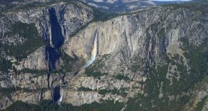
Views of snow capped mountains and flowing waterfalls were our reward once we made it to the top but Yosemite Falls with rainbows was also pretty darn special. Where: Yosemite National Park Distance: 9.85 Miles Difficulty: Moderate to Strenuous Elevation Range: 3,980′ – 7,221′ Date: November 4, 2016 Maps: El Capitan Topographic Quad Dog Hike? No, dogs not allowed in ...

Read More »

Hiking from Nelder Grove to Kelty Meadow

We headed up to Nelder Grove to check out those fall dogwoods and we discovered surprises along our adventure to Kelty Meadow. Distance: 8.44 miles (but you can go more or less if you want to) Difficulty: Easy to moderate Elevation Range: 5,275′ – 6,115′ Date: October 26, 2015 Topographic Quad Map: Falls Ridge Topographic Quad Dog Hike? Absolutely!! It ...

Read More »

Hiking through Mono Meadow and along the Buena Vista Trail

I had never hiked out through Mono Meadow and beyond in the fall and since Tioga Road was temporarily closed due to rockfalls, it sounded like a good workout with the possibility of seeing some fall color. Where: Yosemite National Park Distance: 12.65 Miles Difficulty: Easy to Moderate Elevation Range: 6,361′ – 7,264′ Date: October 20, 2016 Maps: El Capitan, ...

Read More »

Hiking with Sally from Tyee Lakes to Lake Sabrina

Sally and I hiked some new country, full of yellow aspens along the South Fork of Bishop Creek and when we reached the high points of our climb, we had magnificent views of colorful high mountains. Where: Inyo National Forest, John Muir Wilderness Distance: 8.09 Miles Difficulty: Moderate Elevation Range: 9,052′ – 11,592′ Date: October 11, 2016 Maps: Mount Darwin ...

Read More »

Hiking with Sally from Lundy Lake through Mill Creek Canyon

Sally and I followed the footprints of miners that lived in the towns of Lundy and the long gone town of Wasson to check out those gold producing mines. As we followed those old roads and trails, we took in the fall colors and reflections in the beaver ponds along the way. Where: Inyo National Forest, Hoover Wilderness Distance: 10.23 ...

Read More »

Hiking to Chittenden Lake

Fall creates such intense orange and red colors in this area, you probably will think that I doctored the pictures but I didn’t. And those reflections in Chittenden Lake look like a painting, but they are not. Where: Sierra National Forest, Ansel Adams Wilderness Distance: 14.18 Miles Difficulty: Moderate Elevation Range: 7,507′ – 9,222′ Date: September 20, 2016 Maps: Merced ...

Read More »

Hiking to the Top of Mount Dana

Mount Dana is the second highest mountain in Yosemite (after Mount Lyell), reaching 13,061 feet tall. “Slow but steady” was our motto as we climbed the 3,000′ gain in elevation over 2 1/2 miles. Where: Yosemite National Park Distance: 5.21 Miles Difficulty: Strenuous Elevation Range: 9,930′ – 13,061′ Date: September 15, 2016 Maps: Falls Ridge and June Lake Topographic Quads ...

Read More »

Hiking and Fishing with Sally to Z and Shamrock Lakes

Sally and I searched for the footprints that miners made in the Tioga Pass area long ago. We found a few of them but also discovered beautiful reflections in high lakes and caught a few trout while we wandered in the high country. Where: Hoover Wilderness Distance: 8.74 Miles Difficulty: Moderate Elevation Range: 10,094′ – 10,524′ Date: September 7, 2016 ...

Read More »

Hiking up to Cora Lakes

We hiked up to lakes that were smooth as glass and full of reflections. A really nice, big, flat rock made a dandy place for lunch and a siesta. Where: Sierra National Forest Distance: 9.19 Miles Difficulty: Moderate Elevation Range: 9,130′ – 8,434′ Date: September 1, 2016 Maps: Merced Peak Topographic Quads Dog Hike? Maybe We drove up Beasore Road ...

Read More »
Sierra News Online

Sierra News Online