Home » Author Archives: Candace Gregory (page 31)

Author Archives: Candace Gregory

Brown’s Ditch Hike

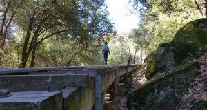
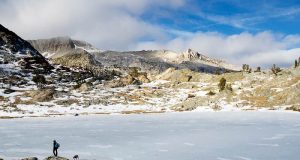
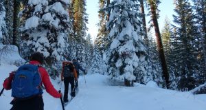
If you don’t like heights or walking on a narrow metal grid on top of a flume as it crosses over deep draws, this hike probably is not for you. Where: Sierra National Forest, Brown’s Ditch is owned and operated by PG&E Distance: 4.89 Miles Difficulty: Easy to Moderate Elevation Range: 3,439′ – 3,780′ Date: December 29, 2016 Maps: Ahwahnee ...

Read More »

Snowshoeing Tamarack Ridge

Fresh snow and lots of it called to us from above Shaver Lake where we had the bluest of skies, white and sparkling new snow to snowshoe on and gorgeous scenery. Where: Tamarack Ridge SNO-PARK, Sierra National Forest Distance: 3.03 miles Difficulty: Moderate Elevational Range: 7,562′ to 7,789′ Date: January 13, 2017 Maps: High Sierra Ranger District Winter Recreation Guide, Dinky ...

Read More »

Hiking up Central Camp Road

An old railroad, lumber camp days, a beaver pond and Ginger Rogers all have something in common with our hike up Central Camp Road. Where: Sierra National Forest Distance: 14.29 Miles Difficulty: Easy to Moderate Elevation Range: 3,514′ – 5,038′ Date: December 22, 2016 Maps: Ahwahnee & Little Shuteye Topographic Quad Maps Dog Hike? Yes, depending on your dog I ...

Read More »

Hiking the Hartman Cutoff

Sometimes you just to need to get outside in winter and take a brisk walk on a dirt road through rolling green foothills with cows. Where: Near Raymond and Coarsegold, following a dirt road. Distance: 9.89 Miles Difficulty: Easy Elevation Range: 1,171′ – 1,752′ Date: December 19, 2016 Maps: Ben Hur and Daulton Topographic Quad Maps Dog Hike? Yes, depending ...

Read More »

Favorite Local Dog Hikes of SNO Readers

Favorite Dog Hikes of SNO Readers Thank you to the SNO readers who shared their favorite dog hikes with me. I look forward to adding more to this “living document” as more come in. I have included some basic information on these dog hikes and purposefully did not include detailed information on health, safety and conditioning related to hiking with ...

Read More »

Hiking the Lewis Creek Trail to Corlieu Falls and Beyond

Storms were scheduled to come in later in the day and we were thinking of a hike close to home, so we headed up the Lewis Creek Trail, traveling back in time as we walked along what was once the Sugar Pine Madera-Sugar Pine Lumber Company flume. Where: Sierra National Forest Distance: 3.81 Miles Difficulty: Easy to Moderate Elevation Range: ...

Read More »

Snowshoeing from Chinquapin to Monroe Meadows

The first big snow of the season had fallen and we needed to check out the conditions. We were pleasantly surprised to find lots of fresh, virgin snow to snowshoe along the historic route that we know of as Old Glacier Point Road. Where: Yosemite National Park Distance: 5.59 Miles Difficulty: Moderate to Strenuous Elevation Range: 6,071′ – 7,281′ Date: ...

Read More »

Tioga Pass High Country before the Storms

The National Weather Service was forecasting storms lining up over the next week or so and I knew that the snow from those storms could shut down Tioga Road for the season. That made me sad, so Sally and I headed up to the Tioga Pass area to check out some of my favorite high lakes in the Tioga Pass ...

Read More »

Hiking from Olmsted Point to Mt. Watkins and Beyond

It was a warm November day and Tioga Road had just re-opened. We had the trail and amazing views all to ourselves of Half Dome, Clouds Rest, Tenaya Canyon and the snow covered peaks beyond. It was a perfect day in my book! Where: Yosemite National Park Distance: 11.77 Miles Difficulty: Easy to Moderate Elevation Range: 7,437′ – 8,497′ Date: ...

Read More »
Sierra News Online

Sierra News Online