YOSEMITE – Oct. 16, 2020 – There are multiple fires burning in Yosemite National Park. Each fire is burning in fire adapted ecosystems in Wilderness. There are trail closures in effect.
All fires may be visible from Tioga Road (Highway 120 through Yosemite National Park), Glacier Point, and high country vistas. Smoke from each fire is settling locally at night, rising in the morning, and dispersing to the north and northeast in the early afternoon.
Park managers are working with the local Air Quality Districts to monitor smoke impacts in the park and local communities. Smoke from ongoing regional fires continues to impact the area. Please heed all signed trail closures and follow all traffic controls in areas you will be visiting.
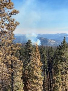
Blue Jay Fire from Tioga Road (Highway 120 through Yosemite National Park). October 14, 2020. NPS Photo
Blue Jay Fire
Location: Yosemite Creek drainage south of the 10 Lakes trail at 9,000 feet elevation.
Discovery Date: July 24, 2020
Size: 6,640 acres
Containment: 50%
Strategy: Confine and Contain
Cause: Lightning
Activity is minimal. Fire is smoldering and backing through ground litter and pockets of accumulated dead and down logs, with some isolated single tree torching. Primary direction of growth is to the north and northeast from Tioga Road at McSwain Summit. Weather conditions may create potential for increased fire behavior. There may be impacts to Tioga Road (Highway 120 through Yosemite National Park). For park road information call 209-372-0200 Press 1 then 1.
inciweb.nwcg.gov/incident/6888/
Wolf Fire
Location: North of White Wolf Campground and west of Lukens Lake Trail at 9,000 feet elevation.
Discovery Date: August 11, 2020
Size: 1,776 acres
Containment: 60%
Strategy: Confine and Contain
Cause: Lightning
The fire has shown minimal growth, primarily on the southeastern edge. It is active in some areas with low intensity. It is smoldering in dense pockets of vegetation and accumulated dead and down logs. Fire is creeping along the forest floor with some isolated single tree torching. Weather conditions may create potential for increased fire behavior.
inciweb.nwcg.gov/incident/7134/
North Whizz Dome Fire
Location: South of Cathedral Creek and 1 mile northwest of Tioga Road at 8,400 feet elevation.
Discovery Date: August 27, 2020
Size: 195 acres
Containment: 0%
Strategy: Monitor
Cause: Lightning
The fire has shown minimal activity with a 15% active perimeter, primarily on the western edge. The fire is smoldering and creeping through ground litter and in pockets of accumulated dead and down logs, with isolated single tree torching. Fire personnel will continue to monitor fire behavior and growth. Smoke may be visible from Tioga Road.
inciweb.nwcg.gov/incident/7135/
Horse Fire
Location: Horse Ridge, 1 mile southeast of Ostrander Lake at 9,500 feet elevation.
Discovery Date: August 24, 2020
Size: 21 acres
Containment: 50%
Strategy: Monitor
Cause: Lightning
The fire has shown no growth. Activity has been mainly inactive, with minimal smoldering pockets of compact high elevation fuels within the perimeter. There are no threats to trails or infrastructure. Fire personnel will continue to monitor fire behavior and growth.
https://inciweb.nwcg.gov/incident/7149/
Yosemite Fires Map Printable PDF
Air Quality: Yosemite Air Quality Page or gov or airnow.gov/fires
Sign-up for Alerts: nps.gov/alert