SIERRA NATIONAL FOREST – When the Junction Fire broke out in the heart of the Oakhurst community, concerns over what was happening on the French Fire near North Fork fell by the wayside as everyone focused on this new and immediate threat.
Now with the danger passed in Oakhurst and the approach of the fall hunting and camping season on the Sierra Vista Scenic Byway, access to the burn area is still restricted to crews and contractors only, and many are wondering what to expect over the next few months.
The French Fire was reported on the morning of July 28, 2014, in the Rock Creek drainage, directly across the San Joaquin River canyon from the genesis of last year’s Aspen Fire. As Bass Lake District Ranger Dave Martin noted, “Right in the exact place we were worried about last year, had it spotted across the canyon.”
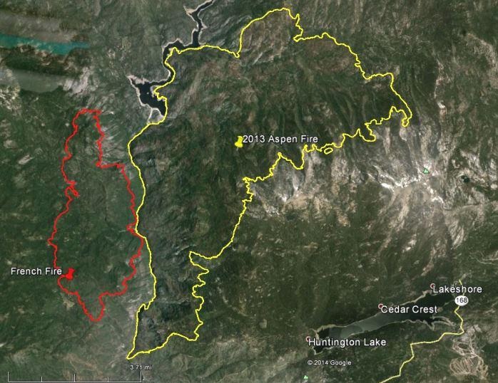 The map of the two fires shows a nearly mirror image, with both starting in extremely steep and rugged terrain where initial attack was hampered by extreme fire behavior and rapid spread. The French Fire went from 5 to 100 acres in about an hour, and the inversion layer prevented putting aircraft in the air.
Martin says he has never seen fire conditions like this, ever.
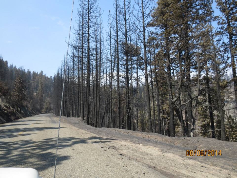
“The fire frequency in this area used to be three to fifteen years,” he says. “You’d have a nice happy little ground fire burning along through the bear clover. But in this fire, some areas burned really hot, and there is nothing left but black sticks.”
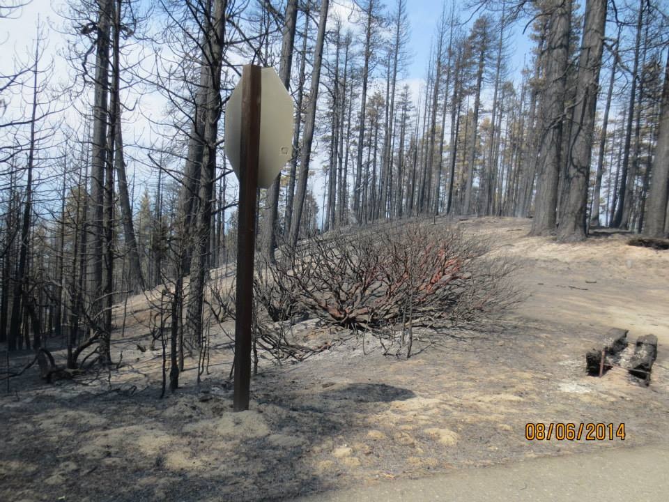
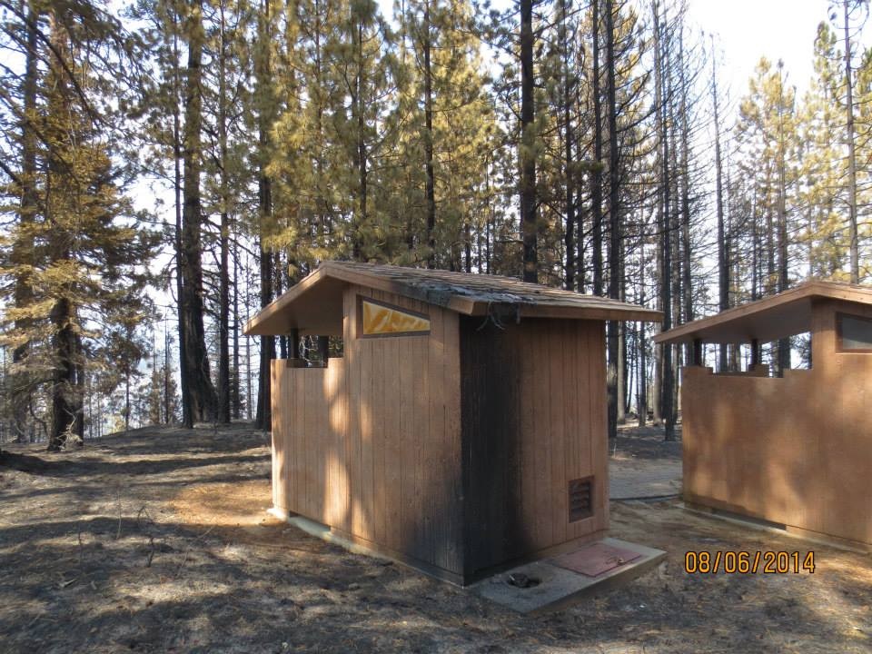
One of those areas is Mile High Vista, where not much survived but the restrooms.
 “Because of the drought, the heavy fuels, such as large logs and stumps, are at only about 4 percent moisture content,” says Martin. “Even the green trees are only about 60 percent.” And those deceptively healthy-looking green trees are what is posing the greatest danger to anyone in the burn area.
“Those green trees look perfectly fine, but what you can’t tell by looking at them is that their roots are completely burned out. Just a breath of wind will blow them over. The Scenic Byway is very, very unsafe.”
So what will the Forest Service do to mitigate the danger, restore the forest and get the Byway reopened to the public?
 The first order of business will be to remove hazard trees along the roadway and in campgrounds. Amazingly, Rock Creek and Fish Creek campgrounds survived basically intact, with the fire burning around them both. However, Forest Road 81, known locally as Mammoth Pool Road or Minarets Road, is lined with untold number of trees, just waiting for a gust of wind to send them crashing onto the roadway.
The National Environmental Policy Act (NEPA) sets regulations for how the Forest Service needs to go about assessing the area and planning for hazard mitigation, reforestation and repair. The Fores Service is required to prepare an Environmental Impact Statement (EIS), which is reviewed by the Environmental Protection Agency.
The local district will send out a team into the burn area, made up of hydrologists, botanists, wildlife biologists, aquatic biologists, foresters, fuels specialists and other experts in their field, to assess the damage. Then they will sit down and make a plan.
The Bass Lake Ranger District has an EIS that was done several years ago, and they hope it will be adequate to address the immediate need to eliminate hazard trees.
“The NEPA analysis doesn’t last forever,” says Martin. “Things change over time. You may have a new creature listed or other changes to conditions that require a reevaluation, but we don’t believe there are any additional concerns at least for the road hazard work. If there are, we may have to do a quick supplement.”
 Martin says they will mark all the hazard trees and put them together in a contract that goes out for bid. The highest bidder will then come in and do all the work required along the roadways, and haul away the designated trees. The money raised from this timber sale will be used to fund the other parts of the plan.
“We have no environmental analysis that allows us to do salvage outside of the road hazard work, so we’ll be starting on that over the winter and looking at the sale of those trees, probably in the spring,” says Martin.
With so many laws governing the management of the national forests, some with cross-purposes, it is a fine balancing act between the environmental needs of the forest and the economic needs of the taxpayers over the value of these trees. How many snags should be left for the benefit of wildlife, and how many should be removed to pay for reforestation and repair? And will part of that restoration include planting new trees?
“We could wait until things slowly seed in, or we can speed up the process by replanting,” says Martin. “And if you replant, you don’t want a bunch of snags hanging round to fall and damage the small trees, or falling over and hurting the tree planters.”
Another area of concern is the French Trail, which runs through the entire burn area and lent its name to the incident. The trail is well-used by hikers and equestrians, and remains closed, as the same hazards exist along the entire length, including a wooden structure bridge over one of the drainages. It is expected that with the first decent rainstorm, the water will come up so high it will wash the bridge out. The plan is to partially dismantle the bridge and move it off to the side, then restore it in the spring. There is also the danger posed by large stumps that have burned down into the roots, but the deep holes are not apparent until someone steps into them.
In order to salvage the countless trees in the 14,000 acre burn area, the Forest Service may decide to follow that same path as was taken by officials following the Rim and Aspen fires, and ask the Washington, D.C. office for an expedited review, allowing them speed up the process before the timber deteriorates to the point that it’s not worth anything from a monetary point of view.
But in the meantime, they will be formulating their plan of action for the burn area. After the plan is finalized, there will be a period for public comment and objections, which will be publicized to allow interested parties to have their say.
As for the current situation on the French Fire, the incident was called 100 percent contained earlier in the week, which means the fireline around the entire perimeter is now secure and there is no danger of the fire spreading. The spike camp for firefighters at Minarets Work Center is now gone, but it will be another one to two weeks before the fire is determined to be “controlled,” which means all hot spots and smokes are dead out. The incident will go into patrol status, with crews monitoring the area for any possible flare-ups.
All along the Scenic Byway are crews and aircraft from Southern California Edison, working to repair and replace about six miles of poles and power lines that run right through the middle of the burn, from Powerhouse No. 8 to Mammoth Pool. Those lines are used to manage the water system, and regulate the opening and closing of the gates for the release of water downstream.
Edison crews are dropping hazard trees along these lines and have set up operations at the Clearwater Station, where helicopters are staged to lift new power poles into place. They are about 30 percent complete with that project, and have trucks and personnel moving up and down Mammoth Pool Road.
Road closures are in effect on Forest Road 81 from just north of Kinsman Flats at Powerhouse No. 8, to the west fork of Chiquito Creek just south of Soda Springs Campgound. Grizzly Road, between FS81 and Beasore, is open. The road down to Mammoth Pool is open, but the road on the west side of Mammoth Pool that crosses Chiquito Creek is closed. Road 8S09 in the Whiskey Falls area to Road 7S02 is still closed. Call the Bass Lake Ranger District in North Fork at 559-877-2218 for more details or changing conditions.
District Ranger Martin says he knows deer hunting season is coming up and a lot of people want to get out into the woods and wonder when things will open up again.
“We can’t accurately predict when that will happen, but hopefully by rifle season,” he says. “I don’t want to pretend that something is safe when it isn’t, and having someone go in and get hurt is the last thing we want. We want to open it up as fast as we can, but it has to be with safety.”
(For more photos of Rock Creek, Fish Creek and Mile High Vista, click here.)


To Whom it may concern
I think send some tree fallers in to
these areas and start cutting these
hazard trees down or maybe some logging
companies it must be done as soon as
possiable and yes i agree I hate to see
anyone to get hurt out there. And my
other concern when its a bad drought
and its is so dry. I feel maybe like
do a permit only type of camping and
we can keep more track of people when
they go into these areas like wood
permits and the other areas police
them and take action to whom does not
obey by these laws.And yes it would be
hard to keep track but something must
be done. I work many years up in the
logging companies it such memory for
me and now its almost all destoryed
by someone that did not care its a
dirty shame.
This portion of the article can’t be accurate…. “Martin says they will mark all the hazard trees and put them together in a contract that goes out for bid. The highest bidder will then come in and do all the work required along the roadways, and haul away the designated trees.” Really, the highest bidder? Gotta love our government!