This mountain bike and hiking area is just west of the Mammoth Pools on the San Joaquin River. It can be reached by driving south about ten miles on rd. 222 out of North Fork and is about four miles north of Auberry, Ca on rd. 222. There are many miles of trails here mostly rolling singletrack but there is a killer technical downhill section. There are three basic rides that can be combined if you really want to. It is wonderful in the early spring as it is warm and the fields are all green and full of wildflowers in bloom.
Ridge trail
This six mile loop trail starts at the lower parking lot about 5 miles west of rd. 222. Ride out of the parking lot past the bathroom and you will come to a gate that keeps the local cow in. Please close the gate behind you. You descend one mile to the river going through another gate before reaching the bridge that will take you across to the actual trailhead. On the right is where you will end up if you take my advice and ride in a clockwise direction. You will start a rolling climb for a little over a mile when you will come to the View trail junction. Continue on the main trail and eventually you will come to a meadow at the top of the hill. It is a great place for a picnic. Now comes the dicey downhill. It is a little rocky and the trail is narrow, but it is quite rewarding.
View trail ( otherwise known as trail to the Bad Dreams Hotel )
Follow the directions above until you come to the sign that says View trail. This out & back four mile trail follows the San Joaquin river on the north bank. It goes up and mostly down the up again at the end where you come upon the rustic Bad Dreams Hotel. It isn’t much to look at but it has great views of the river gorge
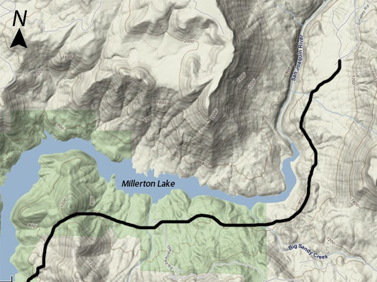
San Joaquin River Trail
After parking in the lower parking lot, ride out the way you came in and go across the road. The 15 mile trail proceeds up to a gate which when you pass through, leads to yet another gate on your way to the Big Sandy Bridge. This was a great endeavor by the Central California Off Road Cyclists to build the concrete footings by hand in preparation for the metal bridge pieces that were air-lifted into place by Army Corps of Engineers helicopters ( find a link to this club in our Local Clubs and Groups page). After the bridge, you wind up and down for about 12 more miles until you come to the Finegold bay on Millerton Lake. This can also be a starting point for this ride if you are coming up from Fresno or Madera. There is an annual mountain bike race held here in April.
Trail info and photos from: http://www.yosemitebicycle.com/


