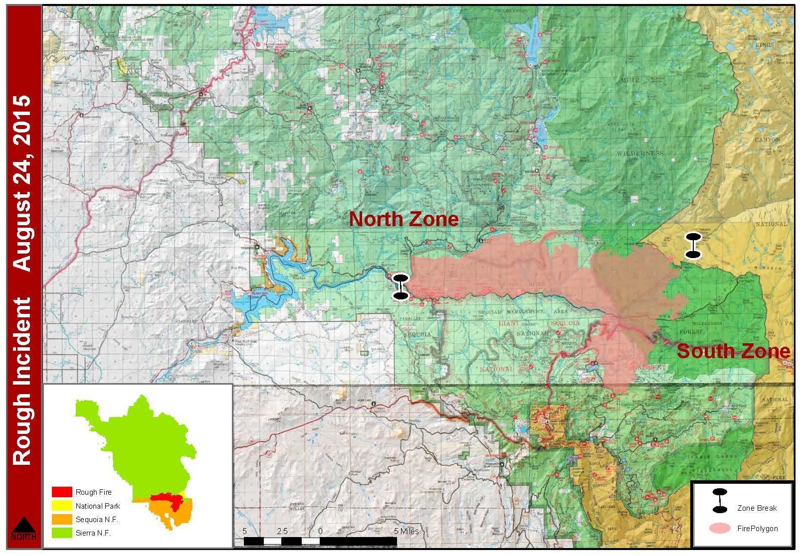
SIERRA NATIONAL FOREST – The Rough Fire, which continues to impact the Central Sierra with dense smoke, has now grown to 49,440 acres, with 17 percent containment.
The fire was reported on July 31, and was lightning-caused. There are currently 2,126 personnel assigned to the incident, including 24 crews, 148 engines and 10 helicopters.
The fire has been divided into two zones, each with its own management team, due to the size and complexity of the incident. The North Zone held a community meeting yesterday for the people who live, work and recreate in the Wishon and Courtright areas. The meeting was held at the Helms PG&E Headquarters and was attended by more than 70 people.
The Incident Commander of the North Zone, David Cooper, provided an overview of the fire situation and the management plans for control. Fresno County Sheriff, Margaret Mims also spoke with the group. Residents were advised by Sheriff Mims to prepare their properties and to work with the firefighters. Remember, Ready, Set, Go!
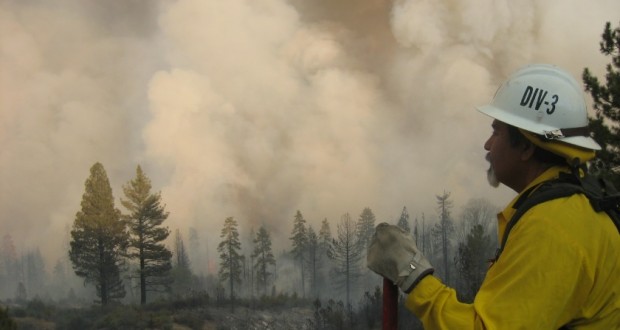
 The rugged terrain of the fire provides numerous hazards for wildland fire fighters. Steep mountains, rolling rocks, and hazard trees make for a dangerous job among the already treacherous risk involved in fighting a fire.
The need for medical personnel has become a higher priority on wildland fires, and a Rapid Extraction Module (REM) is currently assigned to the incident to provide a safe, effective, and efficient way to get an injured firefighter out of rugged areas.
Air and ground resources are not always a reliable option for emergency transportation due to access, smoke or weather conditions. The REM is assigned to be available in close proximity to high risk areas of the fire, where quick extraction is needed, and is made up of approximately six Emergency Medical Technicians who are cross-trained in low angle rope rescue, and wildland firefighting.
The suppression strategy for the Rough Fire will utilize a combination of direct and indirect line, and point protection. A key element of the plan is flexibility and the ability to apply the right resource, to the right task, at the right time, for the right duration. It is understood that fireline will be constructed only where it is feasible and safe to do so. The Incident Commander and staff are working with the Agency Administrators to ensure that the plan is regularly reviewed and updated.
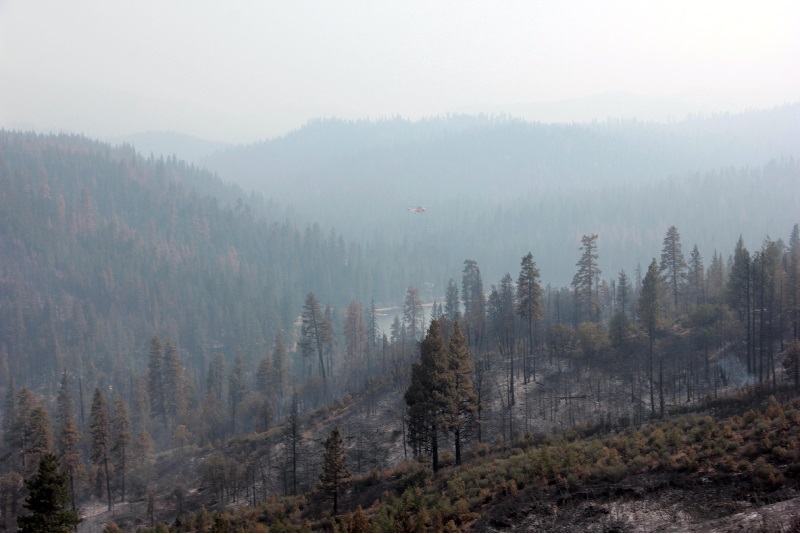
Firefighters are working to slow the growth of the fire towards Hume Lake, constructing firelines with the assistance of air resources, including helicopters dropping water, and as smoke conditions allow, fixed wing aircraft with retardant drops.
Efforts in the Ten Mile drainage have reduced the threat to commercial and residential structures in the Hume Lake area.
 Fire continues to spread towards the Windy Gulch area which includes Lockwood Grove and Evans Grove. A critical fireline is near completion from Highway 180 to the Kings River. Firing activities were conducted to fortify the line from Bailey Bridge to Balch Camp on Balch Camp Rd.
Hand and aerial firing is anticipated to continue over the next several days to keep the fire backing down to the north fork of the King’s River.
The Incident Command Post (ICP) is now located in Squaw Valley along Highway 180. The firefighters and structure protection resources that were assigned to Hume Lake will continue to remain there to protect that infrastructure. California Interagency Incident Management Team 3 (CIIMT3) is in command of the southern half of the Rough fire, and the South Central Sierra Interagency Incident Management Team (SCSIIMT) is in charge of operations on the north.
On the northwest portion of the fire, crews are working to protect the Pacific Gas and Electric infrastructure in the Balch camp area. The Fresno County Sheriff’s Office has issued evacuation warning notices to residents in the area of Sequoia Highlands. These homes are located northeast of Dunlap in small communities known as Crabtree, Sampson Flat, Davis Flat and Clover Meadows. The Sheriff’s Office is alerting residents that they should be prepared to leave at a moment’s notice. As fire conditions change all efforts will be made to inform the public, say officials.
Additional parts of the Grant Grove and Wilsonia areas of Kings Canyon National Park will reopen on Tuesday, Aug. 25. The Kings Canyon Visitor Center will reopen at 8 a.m., and Sunset Campground will open at noon.
Fire crews, engines and equipment are entering and exiting the highway at the ICP located on Highway 180 at Squaw Valley. The reopening of the Grant Grove area to visitors will add to the traffic congestion. Motorists are asked to use extreme caution while driving to Sequoia and Kings Canyon National Park, Giant Sequoia National Monument, Sierra and Sequoia National Forests.
High pressure will remain centered over Arizona through Tuesday and will push northwest towards the fire area. Light winds are expected. Temperatures will trend higher and humidity will trend lower. The inversion layer will persist, causing smoky conditions from midnight to 10 a.m. in many areas.
Though fire activity has lessened over the last few days, local citizens and visitors should stay alert. Sheriff Mims advises residents to prepare their properties and to work with the firefighters. Remember, Ready, Set, Go!
Closures & Advisories:
Sierra National Forest issued a closure order for the Rough Fire Area.
The Grant Grove and Wilsonia areas of Kings Canyon National Park will reopen in stages over the next two days starting today. At noon, the General Grant Tree,
Panoramic Point, park trails, John Muir Lodge, Grant Grove Cabins, restaurant, market and gift shop will be open.
Tomorrow the Kings Canyon Visitor Center will reopen at 8 a.m.
The Hume Lake Ranger District, Jenny Lakes Wilderness and Monarch Wilderness, including Forest Road 12S01, 12S01E, and 12S19 in the Sequoia Highlands area of the Sequoia National Forest remain closed.
The Rough Fire is burning in the Kings River Drainage, 5 miles North of Hume Lake and 2.5 miles southwest of Spanish Mountain, and is being managed on the Sierra National Forest, Sequoia National Forest, and Sequoia & Kings Canyon National Parks.
Fire Restrictions: are in place for the Sierra National Forest. Campfires are only allowed in designated developed recreation sites.
No campfires are allowed within the Sequoia National Forest and Giant Sequoia National Monument.
California is in the midst of fire season. Ensure that you follow local fire restrictions, remain mindful of fire prevention, and maintain required defensible space around your home. In addition, have a plan following the Ready, Set, Go! program to evacuate should the need arise this season. To find out more about what you can do to prevent human caused, unwanted wildfires, please go to www.preventwildfireca.org