MARIPOSA COUNTY – Firefighters had a productive night on the lines as they completed firing operations in several sections of the Ferguson Fire.
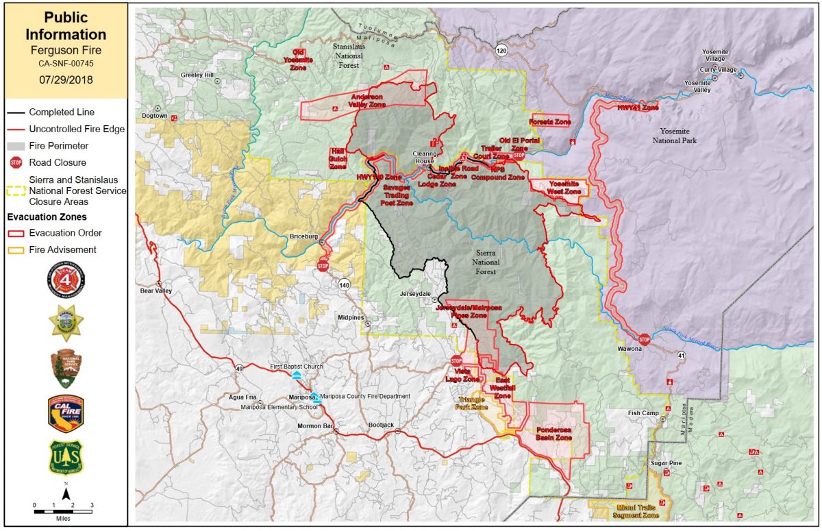
The fire is now estimated at 53,646 acres with 30 percent containment.
Conditions allowed crews to complete firing below Yosemite West from Henness Ridge, southeast to Highway 41 (Wawona Road).
North of Ponderosa Basin, the predicted squirrely winds came from the north out of Devils Gulch to challenge firefighters just after dark last night, but crews were able to catch several spot fires, hold the containment line, and complete firing from Footman Ridge southeast to Roundtree Saddle. This morning there were two more spot fires south of the line, and crews are working on containment.
North of the Merced River on the Stanislaus National Forest, crews fired off the contingency lines on Soapstone Ridge, burning east toward the active fire.
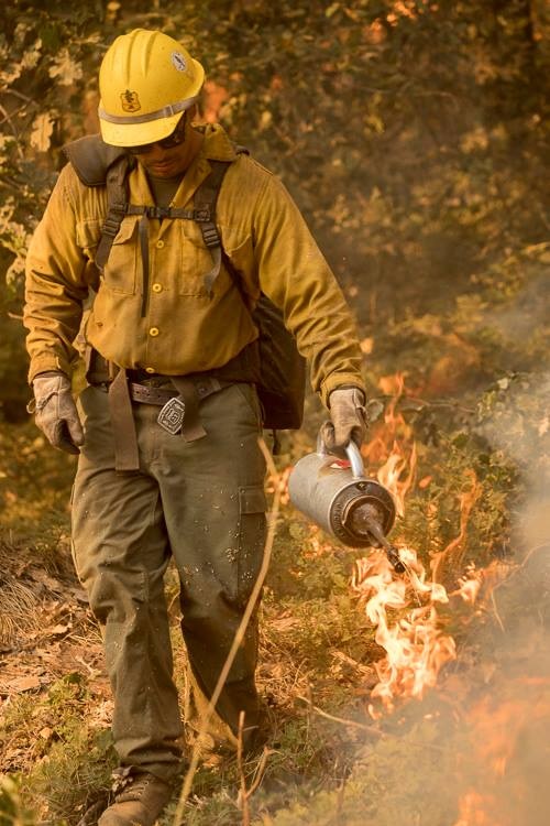
Drip torch on Ferguson Fire – photo USFS
Tactical firing is an effective way to reduce fuel loads while simultaneously widening or extending containment lines. It works to reduce the duration and intensity of wildfires by robbing the fire of available fuels as it approaches containment lines.
During all tactical firing operations on the Ferguson Fire, firefighters and law enforcement maintain a presence in evacuated communities to ensure homes and structures remain safe.
Residents can expect to see smoke plumes throughout the day as tactical firing operations continue, particularly east of the fire along Highway 41 (Wawona Road) inside Yosemite National Park, and across the southern perimeter from Roundtree Saddle toward Wawona Campground.
Air quality is likely to decrease as a result of increased smoke from the firing operations. Residents can monitor the latest air quality and health advisories at:
- https://wildlandfiresmoke.net/outlooks/YosemiteArea
- https://wildlandfiresmoke.net/outlooks/SouthernSierra
There is now an estimated date for full containment of Aug. 15.
Officials estimate 5,236 structures are threatened by the fire, and just one non-residential structure has been destroyed.
There are currently 3,861 personnel assigned to the incident including 272 engines, 93 crews, 45 water tenders, 78 dozers, 16 helicopters, and fixed-wing tankers as conditions allow.
There have been seven firefighter injuries reported, and numerous instances of heat exhaustion-type symptoms. There has been one fatality on the fire.
We will update with details of today’s activity on the firelines after tonight’s briefing.
At 7 p.m. yesterday, evacuation orders for the Triangle Road area were lifted for residents only. These areas will remain under a Fire Advisement of a potential Evacuation Order should conditions change.
Due to the large amount of emergency equipment in the area, speed control will also be enforced.
General Information
Mariposa County Sheriff’s Office will have a heavy presence in the area to ensure the security and safety of residents and businesses.
There will still be smoke in the respective areas as firefighters continue firefighting operations. If at any time you feel unsafe, please call 911.
For questions or concerns regarding power, please contact PG&E at 800-743-5000 or visit their website at www.pge.com.
The Mariposa County Health Department has health and safety information for residents returning to their homes on our website at http://www.mariposacounty.org/health or call 209-966-3689.
Mariposa County Public Works will be at Lushmeadows Store from 10 a.m. – 3 p.m. providing FREE residential spoiled food waste disposal.
Mariposa County Health and Human Services will be available to assist residents with gaining additional services. Additional information regarding these and other services is available at www.mariposacountyrecovers.org.
SAFETY MESSAGE – The public is reminded to stay vigilant on current fire conditions. Please continue to adhere to road closures and any evacuation warnings. If you see electrical wires on the ground, stay clear and contact PG&E immediately. Trees and poles with deep charring, particularly if still smoking, should be considered hazardous. Please drive slowly and yield to emergency personnel in the area. As you re-enter your property and evaluate damage, be aware that hazardous conditions may exist, particularly if a residence or out-building has burned. Hazards may include asbestos, heavy metals, by-products of plastic combustion and various other chemicals. We encourage the public to remain prepared year-round for wildfires by visiting the www.readyforwildfire.org website. The best show of support is having your home and property “fire-ready.”
Make sure you are signed up to receive alerts if wildfire or other emergencies threaten.
- To sign up for the Mariposa Sheriff’s Office Emergency Alert System visit https://local.nixle.com/register.
- To register for the Madera County Sheriff’s Office Emergency Alert System visit mcalert.org.
Yosemite National Park
Officials have announced that Yosemite Valley will reopen to all visitors at 4 p.m. on Friday, Aug. 3. Limited visitor services will be available inside Yosemite Valley, including campgrounds, lodging, and food service operations.
Yosemite Valley has been temporarily closed since July 25 due to smoke impacts and for firefighting operations along El Portal Road and the Wawona Road due to the Ferguson Fire.
The Mariposa Grove of Giant Sequoias and the Wawona Road (Highway 41) from the south entrance of Yosemite National Park to Tunnel View will remain closed until further notice.
The Hetch Hetchy area remains open. The Big Oak Flat Road (Highway 120 West) to Crane Flat and Tioga Road (Highway 120 East) from Crane Flat to Tioga Pass, remain open to all visitors and vehicles. All trails and campgrounds along Tioga Road, including the Tuolumne Meadows Campground remain open. All visitor services along Tioga Road, including the High Sierra Camps and visitor services near Tuolumne Meadows remain open.
Since the Ferguson Fire began on Friday, July 13, several other park facilities and roads have been closed due to fire impacts and the need to support firefighting operations. These closures include Glacier Point Road, Bridalveil Creek Campground, the Wawona Campground, and the Merced Grove of Giant Sequoias.
Yosemite National Park continues to work closely with the Incident Management Team and continues to assess park conditions daily.
For updated 24-hour road and weather conditions for Yosemite National Park, please call 209-372-0200, press 1 and press 1 again. Updated information is also available on the park’s website at www.nps.gov/yose and on the Yosemite National Park Facebook page.
As of July 21, there are fire restrictions in place on the Sierra National Forest. Please read and be informed before you use any type of fire in the forest.
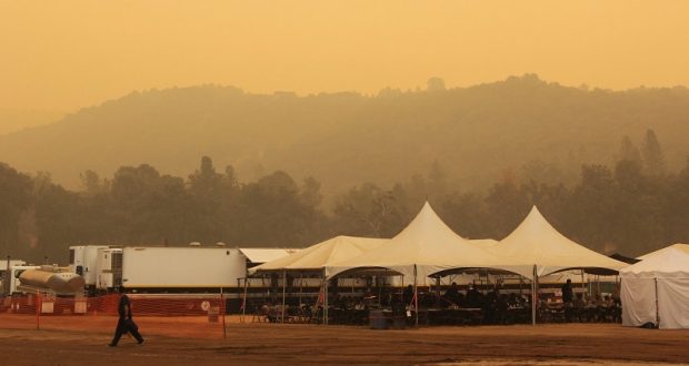
The Incident Command Post for the Ferguson Fire is located at the Ahwahnee Hills Regional Park. Please be aware of heavy fire equipment moving through the area. There is also a base camp set up at the ski area at Badger Pass.
The fire is under Unified Command with Cal Fire, U.S. Forest Service, Yosemite National Park and the Mariposa County Sheriff’s Office. Management of the fire transitioned to a Type 1 Management Team – California Team 4 on Thursday, July 19. For information about the fire please call 530-377-6221.
The Ferguson Fire started on Friday, July 13, at 8:30 p.m. The cause remains under investigation.
Smoke from the Ferguson Fire is impacting the Mariposa County Air Pollution Control District and across the region. For information specific to Mariposa County visit http://www.mariposacounty.org/index.aspx?NID=1434. For additional information on air quality you can visit the AirNow website or the air fire smoke page.
Residents can check the San Joaquin Valley Air Pollution Control District’s wildfire page at www.valleyair.org/wildfires for information about any current wildfires and whether they are impacting the Valley. The District’s Real-time Air Advisory Network (RAAN) provides localized air quality data from an extensive air-monitoring network which allows Valley residents to track PM at any Valley address by visiting myraan.com.
Evacuations
Mandatory evacuations are in place for:
- Savage Trading Post
- Redbud Lodge
- Cedar Lodge
- Indian Flat Campground
- Ferguson Ridge
- Incline Road from Clearing House to the Foresta Bridge in El Portal
- The BLM campgrounds in Briceburg are closed until further notice
- El Portal Trailer Park
- Old El Portal
- Rancheria Flat- Government Housing
- Foresta
- Yosemite View Lodge
- Yosemite West
- Anderson Valley
- Old Yosemite Road
- The north side of Triangle Road from Vista Lago to East Westfall and all side roads to the north
- The north side of East Westfall to Old Mill and all side roads to the north
- East Westfall Road to Chowchilla Mountain Road and all side roads
- Entire Ponderosa Subdivision
Advisories have been issued for the following locations:
- Triangle Road from East Westfall to Highway 49 South and all side roads
This area is NOT under a mandatory evacuation order. This is an advisement only of a potential evacuation order should conditions change.
Should these areas come under a mandatory evacuation order you will be notified via the Sheriff’s Office Emergency Alert System by text, email and a voice call, the Mariposa County Sheriff’s Office Facebook page, and door-to-door communication by Sheriff’s Office staff. At that time you will be notified of the best routes of travel to safely evacuate your residence.
A Red Cross Evacuation Center has been established at Mariposa Elementary School at 5044 Jones Street in Mariposa. This shelter is accepting small pets with their owners.
The shelter at Mountain Christian Center at 40299 Highway 49 in Oakhurst has been closed due to lack of need by evacuees. They remain on standby and will reopen if conditions warrant.
The shelter at New Life Christian Church located at 5089 Cole Road in Bootjack has been closed.
If you have been evacuated due to the Ferguson Fire, the Sheriff’s Office asks that you please check in with the Red Cross Shelter even if you do not plan to stay there.
If you are in a Mandatory Evacuation or Advisory Area and may require assistance with evacuation transportation due to special needs or medical issues, please contact Human Services toll free at 1-833-423-0816 as soon as possible.
Planning ahead will help with a safe and timely evacuation.
Animal Evacuation Centers
Small Animal Shelter is at SPCA of Mariposa County, 5599 Highway 49 in Mariposa is at full capacity.
Residents with small pets can be accommodated at the Mariposa Elementary School Shelter at 5044 Jones Street for those under mandatory evacuation, where Central California Animal Disaster Team (CCADT) is operating an emergency animal shelter. You must check in with Red Cross first. Please try to accommodate your pets with family and friends first, however your pet is welcome to be sheltered if necessary at the Mariposa Elementary School. For questions about pets, please call CCADT at 888-402-2238 ext. 0, and leave a message. Someone will return your call as soon as possible.
Large Animal Shelter is at the Mariposa County Fairgrounds, 5007 Fairgrounds Road in Mariposa.
Road Closures
Highway 140 is closed from the El Portal entrance gate to 14 miles north of Mariposa.
Wawona Road (Highway 41) between Chilnualna Falls Road in Wawona and Bridalveil Fall Road in Yosemite Valley were closed beginning at noon on July 25.
Also closed are:
- Chowchilla Mountain Road at Highway 49 south
- Harris Road at Highway 49 south
- All roads inside Ponderosa Basin Subdivision
- Hites Cove Road from Bear Clover Road to the Merced River
- River Road from Briceburg to the gate at Railroad Flat and all campgrounds
- Anderson Valley Road
- Old Yosemite Road
- Summit Road
- East Westfall Road and all side roads
- Vista Lago Lane
- Monte Vista Lane
Cooperating Agencies include the Mariposa County Sheriff’s Office, Madera County Sheriff’s Office, CAL OES, California Highway Patrol, Caltrans, California Department of Corrections and Rehabilitation, American Red Cross, National Weather Service, California Conservation Corps, BLM and additional agencies throughout the state.