MARIPOSA COUNTY – The Ferguson Fire grew by nearly 8,000 acres overnight and is now estimated at 89,633 acres with containment remaining at 35 percent.
There has been no update from park officials on the reopening of Yosemite previously scheduled for today at 4 p.m. We expect to hear from them soon that portions of the park currently closed will remain so, and will update when that happens.
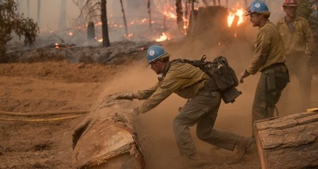
Low humidity recovery kept fire behavior fairly active throughout the night.
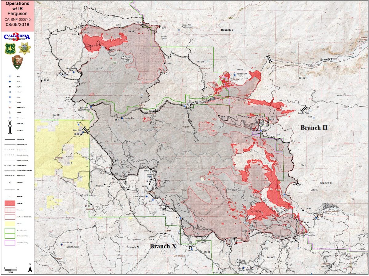
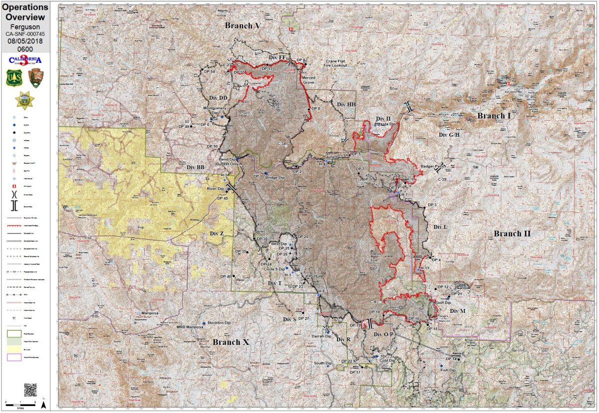
Along the northwest perimeter, crews performed tactical burning along the 13 Road back toward the main body of the fire. That section of the line became very active yesterday afternoon as winds shifted and the fire spotted out up to a mile ahead of itself. Crews were unable to engage the fire directly, and pulled back to safety zones. The fire did stay on the east side of dozer contingency lines, say fire managers.
Officials continue to evaluate the situation on Highway 120 several times a day to determined when it will be safe to reopen. Due to the large number of hazard trees burning next to the road which firefighters are not able to mitigate, Highway 120 remains closed. Highway 41 also remains closed. Highway 120 to Lee Vining (Tioga Pass) is the only entrance to Yosemite.
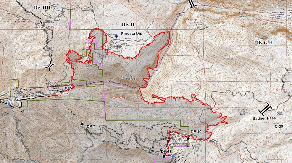
The fire has burned around the west side of Foresta, and continues to move north and west near Eagle Peak above El Portal. Crews continue to protect structures in the community and none have been reported damaged or destroyed.
East of Foresta, the fire is moving northeast along the Merced River canyon into the gap between Big Oak Flat Road and Highway 140.
Structure protection continues in Yosemite West and as of this morning’s report, no structures have been lost.
Crews began constructing contingency lines inside Yosemite National Park as fire remained active around Chinquapin, with spotting up to a half-mile into the park.
Firefighters will take advantage of existing roads and natural features as they build containment lines from Elephant Rock to the burn scar of the 2017 Empire Fire.
Fire behavior in the Glacier Point Road area continues to be active. The fire is now well established in the south fork of Grouse Creek. All firefighters and support personnel were evacuated from the fire camp at Badger Pass yesterday.
After days of delay while a spot fire near Wawona was secured, firefighters will complete the tactical burning south of Wawona to the South Fork of the Merced River as conditions allow. Once that southeast perimeter is secured, resources will be freed up to assist with other parts of the fire.
Along the southern perimeter and the western flank of the fire, everything remains within containment lines and restoration work has begun in Jerseydale, Mariposa Pines and Sweetwater.
There are currently 2,792 personnel assigned to the incident including 218 engines, 59 crews, 65 water tenders, 29 dozers, 5 masticators, 14 helicopters, and fixed-wing tankers as conditions allow.
High temperatures continue across the fire’s perimeter with humidities dropping into the teens in some areas, causing increased fire behavior and spotting. Weather forecasters on the fire warn that overnight humidity recovery is expected to be only between 20 and 40 percent and in some places, never getting out of the teens.
There are currently 995 structures threatened by the fire. Ten structures have been destroyed, though officials do not believe that any of those structures had been recently inhabited.
Damage assessment teams have been able to get into some of the burn areas of the fire, and report the 10 structures lost have been in the Ned Gulch area on the north end of the fire. Officials say it appears that the road had been washed out for some time, requiring teams to go on foot to assess the damage. We will provide more details as they become available.
There is an estimated date for full containment of Aug. 15.
There have been eleven firefighter injuries reported, and numerous instances of heat exhaustion-type symptoms. There have been two fatalities on the fire; HFEO Braden Varney was killed in a dozer rollover accident on July 14, and Brian Hughes, Arrowhead Hotshot Captain, lost his life on July 29 when he was struck by a tree during a firing operation.
If community members see new fire activity, they are asked to call 911, not the fire information line.
As of July 21, there are fire restrictions in place on the Sierra National Forest. Please read and be informed before you use any type of fire in the forest.
The Incident Command Post for the Ferguson Fire is located at the Ahwahnee Hills Regional Park. Please be aware of heavy fire equipment moving through the area. There is also a base camp set up at the ski area at Badger Pass, and another on the Stanislaus National Forest.
Cal Fire has exited Unified Command as of 6 a.m. Thursday, July 26, because of reduced threats to state and private lands. Cal Fire remains committed to the Ferguson Incident as an assisting agency. California Interagency Incident Management Team 3, led by Incident Commander Mark von Tillow, has assumed management of the Ferguson Fire as of 6 a.m. Friday, Aug. 3, transitioning in for California Team 4, which had be managing the fire since July 19.
For information about the fire please call 530-377-6221.
The Ferguson Fire started on Friday, July 13, at 8:30 p.m., near Savage Trading Post on the south side of the Merced River canyon along Highway 140. The cause remains under investigation.
Area residents can expect to see increased smoke during the next few days as firing operations continue and the high pressure system over the fire weakens. Residents can monitor the latest air quality and health advisories at:
- https://wildlandfiresmoke.net/outlooks/YosemiteArea
- https://wildlandfiresmoke.net/outlooks/SouthernSierra
Stanislaus National Forest Supervisor Jason Kuiken has signed a forest order closing several Groveland Ranger District roads and trails impacted by the Ferguson Fire. This closure is based on the current and expected fire behavior and will be in effect until Sept. 30, or until replaced or rescinded. Click here for details and a map of the closure.
Yosemite National Park
Officials have announced that the closure of some portions of Yosemite National Park will be extended to Aug. 5. There has been no update to this information as of this posting. The closure includes Hetch Hetchy. When the park does open these areas, limited visitor services will be available inside Yosemite Valley, including campgrounds, lodging, and food service operations.
Yosemite Valley has been temporarily closed since July 25 due to smoke impacts and for firefighting operations along El Portal Road and the Wawona Road due to the Ferguson Fire.
The Mariposa Grove of Giant Sequoias and the Wawona Road (Highway 41) from the south entrance of Yosemite National Park to Tunnel View will remain closed until further notice.
The Big Oak Flat Road (Highway 120 West) to Crane Flat is closed. Tioga Road (Highway 120 East) from Crane Flat to Tioga Pass, remains open to all visitors and vehicles. All trails and campgrounds along Tioga Road, including the Tuolumne Meadows Campground remain open. All visitor services along Tioga Road, including the High Sierra Camps and visitor services near Tuolumne Meadows, remain open.
Several other park facilities and roads have been closed due to fire impacts and the need to support firefighting operations. These closures include Glacier Point Road, Bridalveil Creek Campground, the Wawona Campground, and the Merced Grove of Giant Sequoias.
Non-essential personnel in Yosemite Valley were evacuated Friday due to hazardous road conditions, smoke and a loss of power, say park officials. Yosemite Valley has been closed to the public since July 25, however Yosemite National Park remains open on the east side out of Lee Vining, and Tioga Pass Road provides access to the Tuolumne Meadows Visitor Center, the Pacific Crest and John Muir trails.
Yosemite National Park continues to work closely with the Incident Management Team and continues to assess park conditions daily.
For updated 24-hour road and weather conditions for Yosemite National Park, please call 209-372-0200, press 1 and press 1 again. Updated information is also available on the park’s website at www.nps.gov/yose and on the Yosemite National Park Facebook page.
Be sure you are signed up to receive alerts when wildfire or other emergencies threaten.
- To sign up for the Mariposa Sheriff’s Office Emergency Alert System visit https://local.nixle.com/register.
- To register for the Madera County Sheriff’s Office Emergency Alert System visit mcalert.org.
Smoke from the Ferguson Fire is impacting the Mariposa County Air Pollution Control District and across the region. For information specific to Mariposa County visit http://www.mariposacounty.org/index.aspx?NID=1434. For additional information on air quality you can visit the AirNow website or the air fire smoke page.
Residents can check the San Joaquin Valley Air Pollution Control District’s wildfire page at www.valleyair.org/wildfires for information about any current wildfires and whether they are impacting the Valley. The District’s Real-time Air Advisory Network (RAAN) provides localized air quality data from an extensive air-monitoring network which allows Valley residents to track PM at any Valley address by visiting myraan.com.
Evacuations
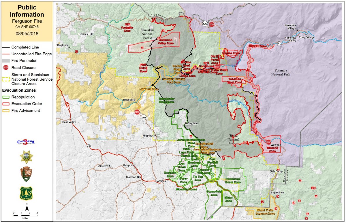
New yesterday: Mandatory evacuations orders were issued for areas that had been populated including Cedar Lodge, El Portal Trailer Court, Incline Road (from Foresta Bridge to Clearing House), Rancheria Flat – Government Housing, and Savage Trading Post. All residents had to leave using Highway 140 to the Midpines area. The road remains closed to the public.
All non-essential personnel were evacuated from Yosemite Valley.
Mandatory evacuations remain in place for:
- Wawona
- El Portal
- Old El Portal
- El Portal Trailer Court
- Incline Road (from Foresta Bridge to Clearing House)
- Rancheria Flat – Government Housing
- Savage Trading Post
- River Road from Briceburg to last BLM Campground
- Foresta
- Yosemite View Lodge
- Yosemite West
- Yosemite Valley
- Anderson Valley
- Old Yosemite Road
A Red Cross Evacuation Center has been established at New Life Christian Fellowship, 5089 Cole Road in Bootjack.
If you have been evacuated due to the Ferguson Fire, the Sheriff’s Office asks that you please check in with the Red Cross Shelter even if you do not plan to stay there.
If you are in a Mandatory Evacuation or Advisory Area and may require assistance with evacuation transportation due to special needs or medical issues, please contact Human Services toll free at 1-833-423-0816 as soon as possible.
Planning ahead will help with a safe and timely evacuation.
Animal Evacuation Centers
The Central California Animal Disaster Team (CCADT) has closed their emergency animal shelter at the Mariposa Elementary School, as all the pets have gone home. If you have small animals and have been evacuated, please call CCADT at 888-402-2238 ext. 0. If no one answers, leave a message. Someone will return your call as soon as possible.
Large Animal Shelter is at the Mariposa County Fairgrounds, 5007 Fairgrounds Road in Mariposa.
Road Closures
- Anderson Valley Road
- Foresta Road
- River Road from Briceburg to the gate at Railroad Flat and all campground areas along 140
- Incline Road (from Foresta Bridge to Clearing House)
- Summit Road
- Old Yosemite Road
- Wawona Road (Highway 41) between Chilnualna Falls in Wawona and Bridalveil Road in Yosemite Valley
- Incline Road and Highway 140 from the entrance to Yosemite National Park to 1.5 miles east of Midpines
- Big Oak Flat Road (Highway 120) west of Crane Flat to Big Oak Flat entrance
General information on returning to previously evacuated areas:
Mariposa County Sheriff’s Office will have a heavy presence in the area to ensure the security and safety of residents and businesses.
There will still be smoke in the respective areas as firefighters continue firefighting operations. If at any time you feel unsafe, please call 911.
For questions or concerns regarding power, please contact PG&E at 800-743-5000 or visit their website at www.pge.com.
The Mariposa County Health Department has health and safety information for residents returning to their homes on their website at http://www.mariposacounty.org/health or call 209-966-3689.
Mariposa County Health and Human Services will be available to assist residents with gaining additional services. Additional information regarding these and other services is available at www.mariposacountyrecovers.org.
SAFETY MESSAGE – The public is reminded to stay vigilant on current fire conditions. Please continue to adhere to road closures and any evacuation warnings. If you see electrical wires on the ground, stay clear and contact PG&E immediately. Trees and poles with deep charring, particularly if still smoking, should be considered hazardous. Please drive slowly and yield to emergency personnel in the area. As you re-enter your property and evaluate damage, be aware that hazardous conditions may exist, particularly if a residence or out-building has burned. Hazards may include asbestos, heavy metals, by-products of plastic combustion and various other chemicals. We encourage the public to remain prepared year-round for wildfires by visiting the www.readyforwildfire.org website. The best show of support is having your home and property “fire-ready.”
Cooperating Agencies on the Ferguson Fire include:
- Bureau of Land Management
- California Conservation Corps
- California Department of Corrections
- California Highway Patrol
- California Office of Emergency Services
- Cal Fire
- Caltrans
- Central Califonia Animal Disaster Team
- Hetch Hetchy Water & Power
- Madera County Sheriff
- Mariposa County Public Works
- Mariposa Public Works
- North Fork Rancheria of Mono Indian of California
- Pacific Gas and Electric
- Red Cross
- San Francisco Department of Emergency Management
- Sierra Tel
- Tuolumne County Sheriff
- Yosemite Mountain Ranch