![]() MARIPOSA COUNTY – The Ferguson Fire, burning south of Highway 140 in Mariposa County, grew by just 500 acres today, according to the latest numbers from fire managers.
MARIPOSA COUNTY – The Ferguson Fire, burning south of Highway 140 in Mariposa County, grew by just 500 acres today, according to the latest numbers from fire managers.
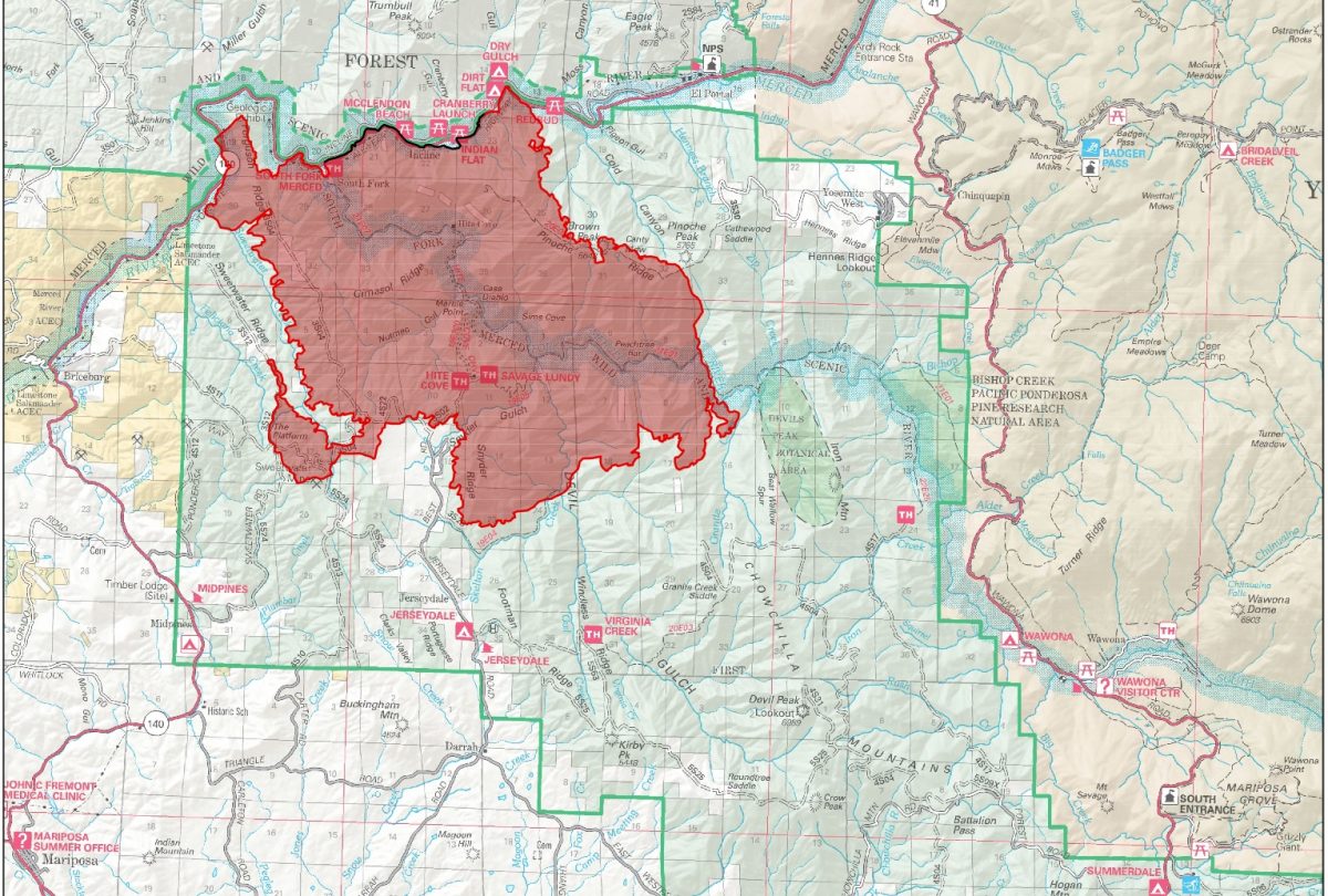
The fire is now estimated at 21,541 acres and is still 7 percent contained.
As of this evening, no structures have been damaged or destroyed.
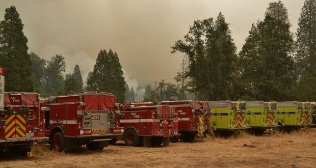
There are currently 2,711 personnel assigned to the incident including 203 engines, 58 crews, 41 dozers, 39 water tenders, 16 helicopters, and fixed-wing aircraft as conditions allow.
As has been the pattern every day on this fire, the inversion kept aircraft grounded much of the day. Visibility was zero this morning, and though helicopters were able to get a bit of work done when visibility improved some, fixed-wing aircraft were forced to sit and wait for cleaner air until very late in the afternoon.
The unusually heavy inversion today kept the fire activity fairly moderate. By 10:30 a.m., cumulus clouds began to develop, but all the buildup over the Sierra was 20 – 30 miles south and east of the fire, keeping anticipated thunderstorms and outflow winds at bay.
On the northwest corner, the fire continued to progress into the “dogleg” created by Highway 140 west of Cedar Lodge. Fire managers are considering aerial ignition in that area to clean up the remaining fuels.
![]() On the western perimeter, the fire made its way to the bottom of Sweetwater drainage by about 9 a.m. Air operations were able to get some good retardant down across the ridge when it was safe to fly. Crews did some firing operations south of the Sweetwater Ridge, but adverse winds caused them to have to suspend burning.
On the western perimeter, the fire made its way to the bottom of Sweetwater drainage by about 9 a.m. Air operations were able to get some good retardant down across the ridge when it was safe to fly. Crews did some firing operations south of the Sweetwater Ridge, but adverse winds caused them to have to suspend burning.
The fireline along Highway 140 across the northern perimeter continues to hold, however the loss of vegetation on the steep canyon walls has created a hazard below, as rocks and burning chunks of debris fall down into the roadway.
The fire continues to move east toward El Portal on the northeastern corner. The roadblock on Highway 140 was pushed a bit farther east as the El Portal Trailer Park was evacuated.
 Crews continue to work on the contingency line that runs from the Merced River west of El Portal, across Henness Ridge to protect the community of Yosemite West, where prep work and structure protection continues.
In the Mariposa Pines area, crews were working all along Snyder Ridge and Snyder Creek Roads, as the fire is right up to the road on the 10 mph curve, and behind homes around the loop of the road. No structures have been lost.
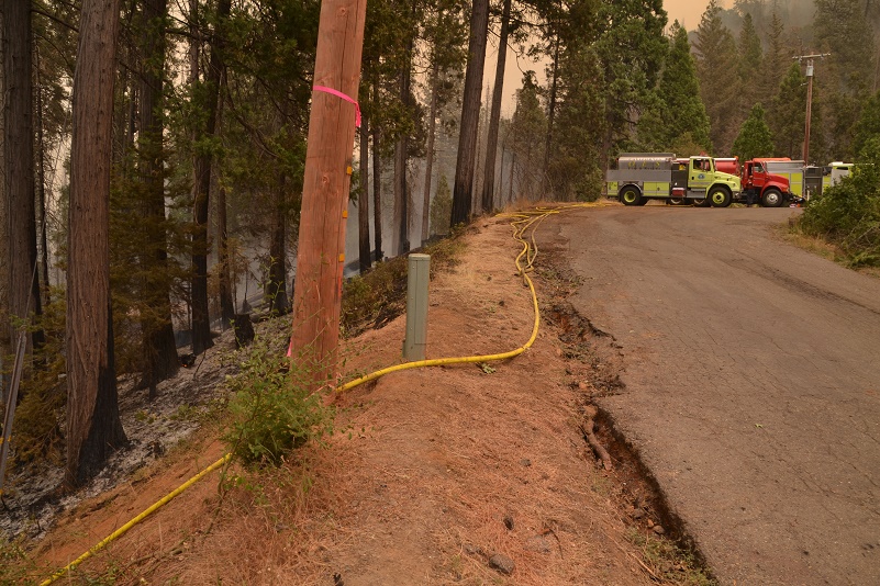
There are engines staged in driveways and firefighters at every home near active fire.
 A staging area has been established at the corner of Hites Cove Road and Best Road, and dozer transports sit empty just south of that location, as operators work to cut contingency lines and strengthen existing lines.
Homes that have been evacuated have been marked with a big X so that firefighters and law enforcement know that no one is in the residence. If people refuse to leave, their mailbox is tagged with a sheet of information about who is still on the property. Those who are sheltering in place are not allowed to leave their property.
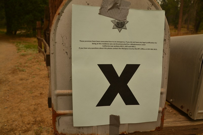 Sheriff’s deputies and Forest Service law enforcement are out in force, patrolling the evacuated areas to ensure that no one who isn’t supposed to be there is allowed to enter.
Dozers continued to cut and improve contingency line down from Footman Ridge to Kirby Peak east of Darrah.
On the southeast perimeter, dangerous, inaccessible terrain and the lack of air operations has kept firefighters from meaningful suppression activity there, but fire managers say it hasn’t moved much over the last 24 hours.
The Glacier Point Road inside Yosemite National Park will close at 10 p.m. tonight, say park officials. Firefighting resources and activities involved in the Ferguson Fire have necessitated the need for a small base camp located at the Yosemite Ski and Snowboard Area (formerly Badger Pass) and Bridalveil Creek Campground (which is also closed).
The fire has degraded air quality and visibility. Conditions may be in the unhealthy range. This means that sensitive groups should avoid prolonged or heavy exertion. Move activities indoors or reschedule to a time when the air quality is better. Everyone else should reduce prolonged or heavy exertion and take more breaks during all outdoor activities.
There are currently 216 structures threatened by the Ferguson Fire.
There have been two firefighter injuries reported. There has been one fatality on the fire.
The Incident Command Post for the Ferguson Fire is now at the Ahwahnee Hills Regional Park. Please be aware of heavy fire equipment moving through the area.
The fire is under Unified Command with Cal Fire, U.S. Forest Service, Yosemite National Park and the Mariposa County Sheriff’s Office. Today management of the fire transitioned to a Type 1 Management Team – California Team 4.
Though the west entrance (El Portal) to Yosemite National Park on Highway 140 is closed, the park remains open. For information on Yosemite National Park, go to nps.gov/yose or call 209-372-0200.
The Ferguson Fire started on Friday, July 13, at 8:30 p.m. The cause remains under investigation.
At 2:15 p.m. today, the Mariposa County Sheriff’s Office issued a mandatory evacuation order for the El Portal Trailer Court, which sits on the south side of the Merced River. With Highway 140 west to Mariposa closed, residents were advised they would need to use Highway 140 through Yosemite to exit. Sheriff’s personnel made door-to-door notice to each residence in the area.
Evacuations
Mandatory evacuations are in place for:
- Savage Trading Post
- Redbud Lodge
- Cedar Lodge
- Indian Flat Campground
- Mariposa Pines
- Sweetwater Ridge
- Ferguson Ridge
- Jerseydale including all residences on Jerseydale Road, Hites Cove Road and all side roads from Triangle Road to the end of Hites Cove Road
- Incline Road from Clearing House to the Foresta Bridge in El Portal
- The BLM campgrounds in Briceburg are closed until further notice
- El Portal Trailer Park
Advisories have been issued for the following locations:
- National Park Service El Portal Complex
- Rancheria Flat – Government Housing
- Old El Portal
- Lushmeadows Community
- Ponderosa Basin Community
- Triangle Road from Jerseydale Road to Highway 49 South including all side roads
- Darrah Road from Triangle to Sherrod Road
- East side of Highway 49S from Darrah Road to Harris Cutoff Road – This includes Boyer Road, Woodland Area, Wass Road and Tip Top Road
- Yosemite West
These areas are NOT under a mandatory evacuation order. This is an advisement only of a potential evacuation order should conditions change.
Should these areas come under a mandatory evacuation order you will be notified via the Sheriff’s Office Emergency Alert System by text, email and a voice call, the Mariposa County Sheriff’s Office Facebook page, and door-to-door communication by Sheriff’s Office staff. At that time you will be notified of the best routes of travel to safely evacuate your residence.
A Red Cross Evacuation Center has been established at the New Life Christian Church located at 5089 Cole Road in Mariposa. If you have been evacuated due to the Ferguson Fire, the Sheriff’s Office asks that you please check in with the Red Cross Shelter even if you do not plan to stay there.
If you are in a Mandatory Evacuation or Advisory Area and may require assistance with evacuation transportation due to special needs or medical issues, please contact Human Services toll free at 1-833-423-0816 as soon as possible.
Planning ahead will help with a safe and timely evacuation.
Animal Evacuation Centers
Small Animal Shelter is at SPCA of Mariposa County, 5599 Highway 49 in Mariposa.
Large Animal Shelter is at the Mariposa County Fairgrounds, 5007 Fairgrounds Road in Mariposa.
Road Closures
Also closed are Jerseydale Road, Hites Cove Road and all side roads from Triangle Road to the end of Hites Cove Road; River Road from Briceburg to the gate at Railroad Flat and all campground areas are closed; Hites Cove Road from Bear Clover Road to the Merced River.
Cooperating Agencies include the Mariposa County Sheriff’s Office, CAL OES, California Highway Patrol, Caltrans, California Department of Corrections and Rehabilitation, American Red Cross, National Weather Service, California Conservation Corps, BLM and additional agencies throughout the state.