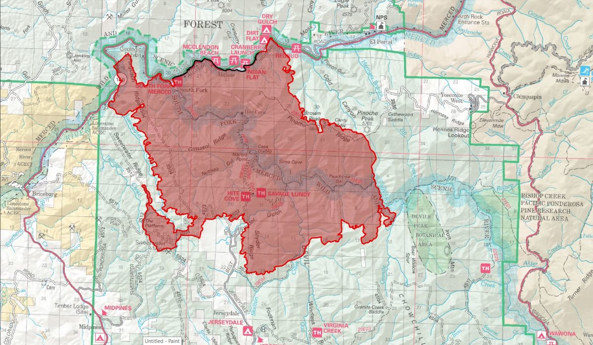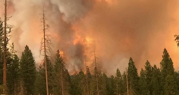
MARIPOSA COUNTY – The Ferguson Fire, burning south of Highway 140 in Mariposa County, has now grown to 21,041 acres and is 7 percent contained.
As of this morning, no structures have been damaged or destroyed, and no further evacuations have been ordered.
There are currently 2,149, personnel assigned to the incident including 166 engines, 55 crews, 29 dozers, 21 water tenders, 18 helicopters, and fixed-wing aircraft as conditions allow.
The fire showed moderate growth overnight, say fire officials. Crews worked late to strengthen the line around Jerseydale and along Sweetwater Ridge, and to complete containment lines along Highway 140 at Cold Canyon.
The fire continued to back west into Sweetwater Creek, north onto Ferguson Ridge, and north toward Highway 140.
In the Jerseydale area, the fire continued to back down the hill. Crews have been conducting burnout operations in that area to to remove fuels ahead of the fire’s approach. Structure protection is a top priority in this area, and firefighters will continue to work on indirect lines (containment lines placed ahead of the fire’s active edge) to protect the community.
Today, crews will continue to build and improve indirect lines along Sweetwater Ridge and from Highway 140 southeast to the Wawona Road (continuation of Highway 41 in Yosemite National Park) along Henness Ridge.
The chance of thunderstorms is predicted to increase today. Thunderstorms can produce erratic winds, causing the fire to change direction quickly and unexpectedly. This is especially dangerous for firefighters working on constructing indirect containment lines as a sudden shift in wind can cause fuel between them and the fireline to burn.
Though the west entrance (El Portal) to Yosemite National Park on Highway 140 is closed, the park remains open. For information on Yosemite National Park, go to nps.gov/yose or call 209-372-0200.
There are currently 108 structures threatened by the Ferguson Fire including 70 homes, 3 commercial buildings and 35 outbuildings. So far no structures have been lost.
There have been two firefighter injuries reported. There has been one fatality on the fire.
The Incident Command Post for the Ferguson Fire is now at the Ahwahnee Hills Regional Park. Please be aware of heavy fire equipment moving through the area.
The fire is under Unified Command with Cal Fire, U.S. Forest Service, Yosemite National Park and the Mariposa County Sheriff’s Office. Today management of the fire will transition to a Type 1 Management Team – California Team 4.
The Ferguson Fire started on Friday, July 13, at 8:30 p.m. The cause remains under investigation.
There have been no additional evacuations or advisories issued in the past 48 hours.
Evacuations
Mandatory evacuations are in place for:
- Savage Trading Post
- Redbud Lodge
- Cedar Lodge
- Indian Flat Campground
- Mariposa Pines
- Sweetwater Ridge
- Ferguson Ridge
- Jerseydale including all residences on Jerseydale Road, Hites Cove Road and all side roads from Triangle Road to the end of Hites Cove Road
- Incline Road from Clearing House to the Foresta Bridge in El Portal
- The BLM campgrounds in Briceburg are closed until further notice
Advisories have been issued for the following locations:
- National Park Service El Portal Complex
- Rancheria Flat – Government Housing
- El Portal Trailer Court
- Old El Portal
- Lushmeadows Community
- Ponderosa Basin Community
- Triangle Road from Jerseydale Road to Highway 49 South including all side roads
- Darrah Road from Triangle to Sherrod Road
- East side of Highway 49S from Darrah Road to Harris Cutoff Road – This includes Boyer Road, Woodland Area, Wass Road and Tip Top Road
- Yosemite West
These areas are NOT under a mandatory evacuation order. This is an advisement only of a potential evacuation order should conditions change.
Should these areas come under a mandatory evacuation order you will be notified via the Sheriff’s Office Emergency Alert System by text, email and a voice call, the Mariposa County Sheriff’s Office Facebook page, and door-to-door communication by Sheriff’s Office staff. At that time you will be notified of the best routes of travel to safely evacuate your residence.
A Red Cross Evacuation Center has been established at the New Life Christian Church located at 5089 Cole Road in Mariposa. If you have been evacuated due to the Ferguson Fire, the Sheriff’s Office asks that you please check in with the Red Cross Shelter even if you do not plan to stay there.
If you are in a Mandatory Evacuation or Advisory Area and may require assistance with evacuation transportation due to special needs or medical issues, please contact Human Services toll free at 1-833-423-0816 as soon as possible.
Planning ahead will help with a safe and timely evacuation.
Animal Evacuation Centers
Small Animal Shelter is at SPCA of Mariposa County, 5599 Highway 49 in Mariposa.
Large Animal Shelter is at the Mariposa County Fairgrounds, 5007 Fairgrounds Road in Mariposa.
Road Closures
Also closed are Jerseydale Road, Hites Cove Road and all side roads from Triangle Road to the end of Hites Cove Road; River Road from Briceburg to the gate at Railroad Flat and all campground areas are closed; Hites Cove Road from Bear Clover Road to the Merced River.
Cooperating Agencies include the Mariposa County Sheriff’s Office, CAL OES, California Highway Patrol, Caltrans, California Department of Corrections and Rehabilitation, American Red Cross, National Weather Service, California Conservation Corps, BLM and additional agencies throughout the state.