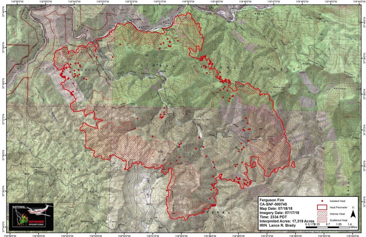
MARIPOSA COUNTY – The Ferguson Fire continues to push out in all directions, growing 4,000 acres overnight.
The fire is now 17,319 acres and is still estimated at 5 percent containment. No new evacuations have been ordered in the past 24 hours.
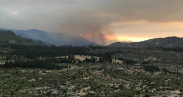
Fire managers describe the fire activity overnight as “fairly quiet,” with activity picking up in the area around Sweetwater Creek shortly before dawn. The fire is now established in the bottom of Sweetwater Creek.
Crews worked overnight on securing line around Cedar Lodge and Indian Flat. The power line has been completed, and power has been restored to the area. Work also continued on containment lines protecting the communities of Jerseydale/ Mariposa Pines and Yosemite West.
Today, crews will continue to monitor and mop up in the areas around Cedar Lodge, Indian Flat and Cold Canyon. They will begin contingency line construction up Pinoche Ridge from the Merced River, improve dozer and handlines around Yosemite West and Jerseydale, and take suppression action to keep the fire East of Snyder Ridge. They will also use aerial resources to try to keep the fire on top of Ferguson Ridge when conditions permit.
Weather today is predicted to be hot and dry, and the smoke inversion is again expected to stay over the area until mid- to late afternoon. Monsoonal moisture is expected to start pushing in from the south, and there may be some thunderstorm buildup over the Sierra crest by late afternoon. Thunderstorms can produce gusty, erratic winds, causing hazards to firefighters.
There are currently 1,850 personnel assigned to the incident including 158 engines, 44 crews, 16 dozers, 5 water tenders, 5 helicopters, and fixed-wing aircraft as conditions allow.
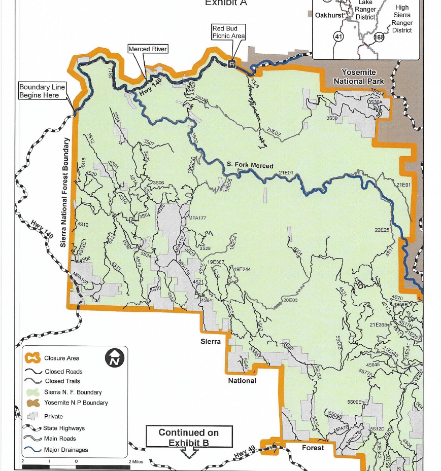
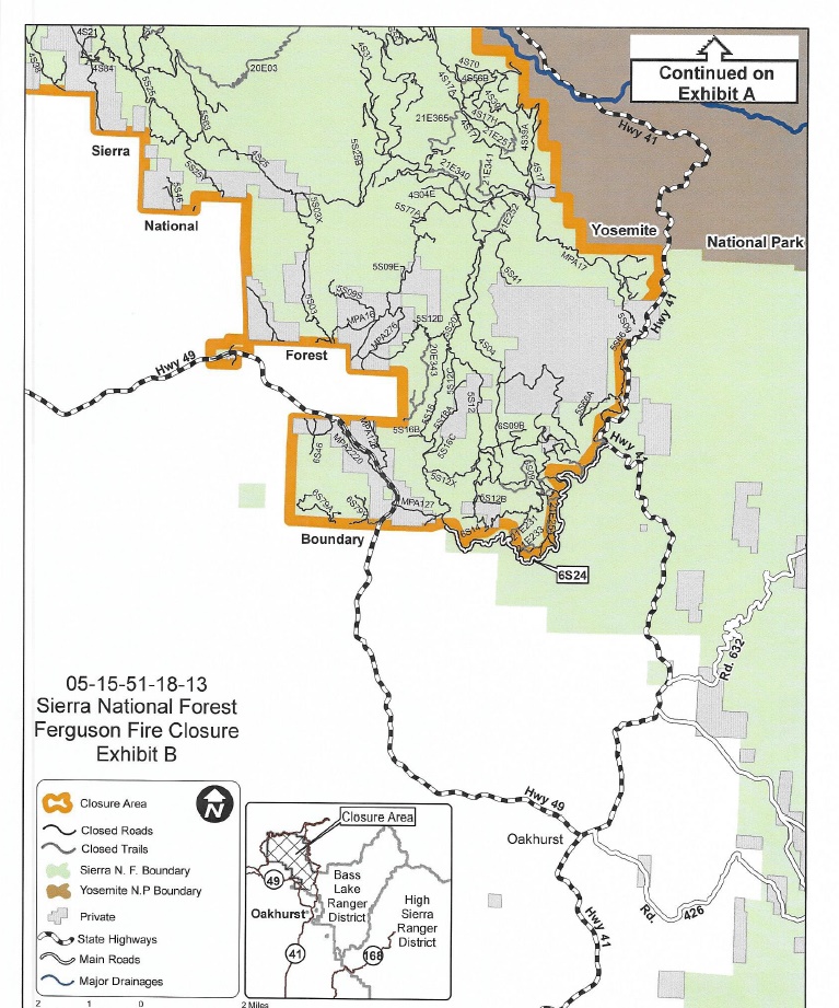
Sierra National Forest Supervisor Dean Gould has issued an order closing parts of the Forest within the Ferguson Fire suppression area:
The purpose of this closure is to provide safety to the public and for the firefighters who are engaged in fire suppression and rehabilitation efforts within the Ferguson Fire Closure Area, as shown on Exhibits A and B. Closure of the fire area is necessary to help ensure that no one is injured within or near the active fire perimeter.
All National Forest System roads and trails, within closure area will be closed due to fire suppression and rehabilitation activities that create a hazard to the public which includes the use of heavy equipment, the falling of hazard trees that were weakened by the fire and the construction, rehabilitation, and maintenance of fuel breaks. This closure will remain in effect until the fire is declared out.
This Order is effective from July 18, 2018, until the Ferguson Fire is declared out.
1. Going into or being upon National Forest System lands within the Ferguson Fire Closure Area. The boundary of the Ferguson Fire Closure Area begins at the intersection of Highway 140 and the Sierra National Forest Boundary, then continues south and east along the Sierra National Forest Boundary to its intersection with Forest Road No. 6S24, then continues east and north along the northern edge of Forest Road No. 6S24 to its intersection with the western edge of Highway 41, then continues north along the western edge Highway 41 to its intersection with the Yosemite National Park Boundary, then continues northeast along the Yosemite National Park Boundary to its intersection with the Merced River near the Red Bud Picnic Area, then continues west along the Sierra National Forest Boundary back to its starting point, as shown on Exhibits A and B. 36 CFR 261.52(e).
2. Being on any National Forest System road within the Ferguson Fire Closure Area, as shown on Exhibits A and B. 36 CFR 261.54(e).
3. Being on any National Forest System trail within the Ferguson Fire Closure Area, as shown on Exhibits A and B. 36 CFR 261.55(a).
Pursuant to 36 CFR 261.50(e), the following persons are exempt from this Order:
- Persons with a permit from the Forest Service specifically authorizing the otherwise prohibited act or omission.
- Any Federal, State, or local officer or member of an organized rescue or fire fighting force in the performance of an official duty.
A violation of these prohibitions is punishable by a fine of not more than $5,000 for an individual or $10,000 for an organization, or imprisonment for not more than six months, or both. (see maps below for closure area).
There are currently 108 structures threatened by the Ferguson Fire including 70 homes, 3 commercial buildings and 35 outbuildings. So far no structures have been lost.
There have been two firefighter injuries reported. There has been one fatality on the fire.
The Incident Command Post for the Ferguson Fire is now at the Ahwahnee Hills Regional Park. Please be aware of heavy fire equipment moving through the area.
The fire is under Unified Command with Cal Fire, U.S. Forest Service and the Mariposa County Sheriff’s Office.
There will be a community meeting at 4 p.m. today at the El Portal Community Center.
The Ferguson Fire started on Friday, July 13, at 8:30 p.m. The cause remains under investigation.
Evacuations
Mandatory evacuations are in place for:
- Savage Trading Post
- Redbud Lodge
- Cedar Lodge
- Indian Flat Campground
- Mariposa Pines
- Sweetwater Ridge
- Ferguson Ridge
- Jerseydale including all residences on Jerseydale Road, Hites Cove Road and all side roads from Triangle Road to the end of Hites Cove Road
- Incline Road from Clearing House to the Foresta Bridge in El Portal
- The BLM campgrounds in Briceburg are closed until further notice
Advisories have been issued for the following locations:
- National Park Service El Portal Complex
- Rancheria Flat – Government Housing
- El Portal Trailer Court
- Old El Portal
- Lushmeadows Community
- Ponderosa Basin Community
- Triangle Road from Jerseydale Road to Highway 49 South including all side roads
- Darrah Road from Triangle to Sherrod Road
- East side of Highway 49S from Darrah Road to Harris Cutoff Road – This includes Boyer Road, Woodland Area, Wass Road and Tip Top Road
- Yosemite West
Should these areas come under a mandatory evacuation order you will be notified via the Sheriff’s Office Emergency Alert System by text, email and a voice call, the Mariposa County Sheriff’s Office Facebook page, and door-to-door communication by Sheriff’s Office staff. At that time you will be notified of the best routes of travel to safely evacuate your residence.
A Red Cross Evacuation Center has been established at the New Life Christian Church located at 5089 Cole Road in Mariposa. If you have been evacuated due to the Ferguson Fire, the Sheriff’s Office asks that you please check in with the Red Cross Shelter even if you do not plan to stay there.
If you are in a Mandatory Evacuation or Advisory Area and may require assistance with evacuation transportation due to special needs or medical issues, please contact Human Services toll free at 1-833-423-0816 as soon as possible.
Planning ahead will help with a safe and timely evacuation.
Animal Evacuation Centers
Small Animal Shelter is at SPCA of Mariposa County, 5599 Highway 49 in Mariposa.
Large Animal Shelter is at the Mariposa County Fairgrounds, 5007 Fairgrounds Road in Mariposa.
Road Closures
Also closed are Jerseydale Road, Hites Cove Road and all side roads from Triangle Road to the end of Hites Cove Road; River Road from Briceburg to the gate at Railroad Flat and all campground areas are closed; Hites Cove Road from Bear Clover Road to the Merced River.
Cooperating Agencies include the Mariposa County Sheriff’s Office, CAL OES, California Highway Patrol, Caltrans, California Department of Corrections and Rehabilitation, American Red Cross, National Weather Service, California Conservation Corps, BLM and additional agencies throughout the state.