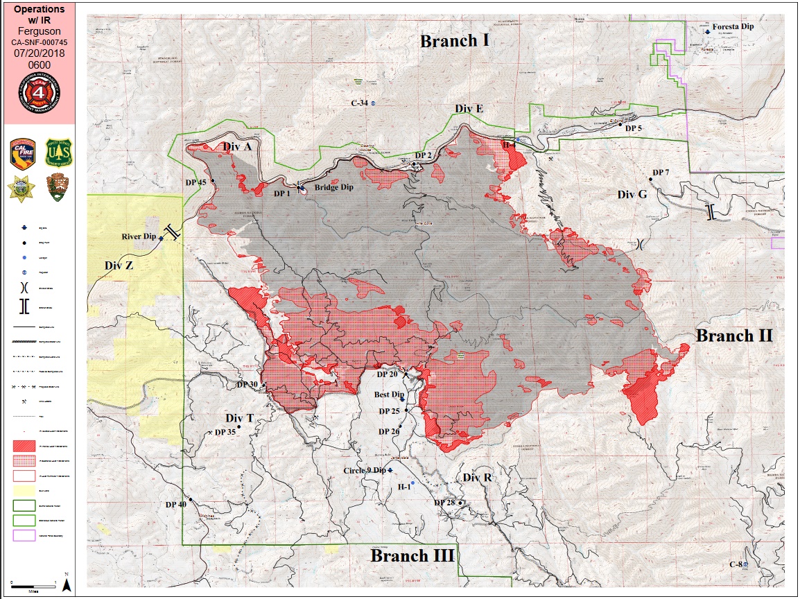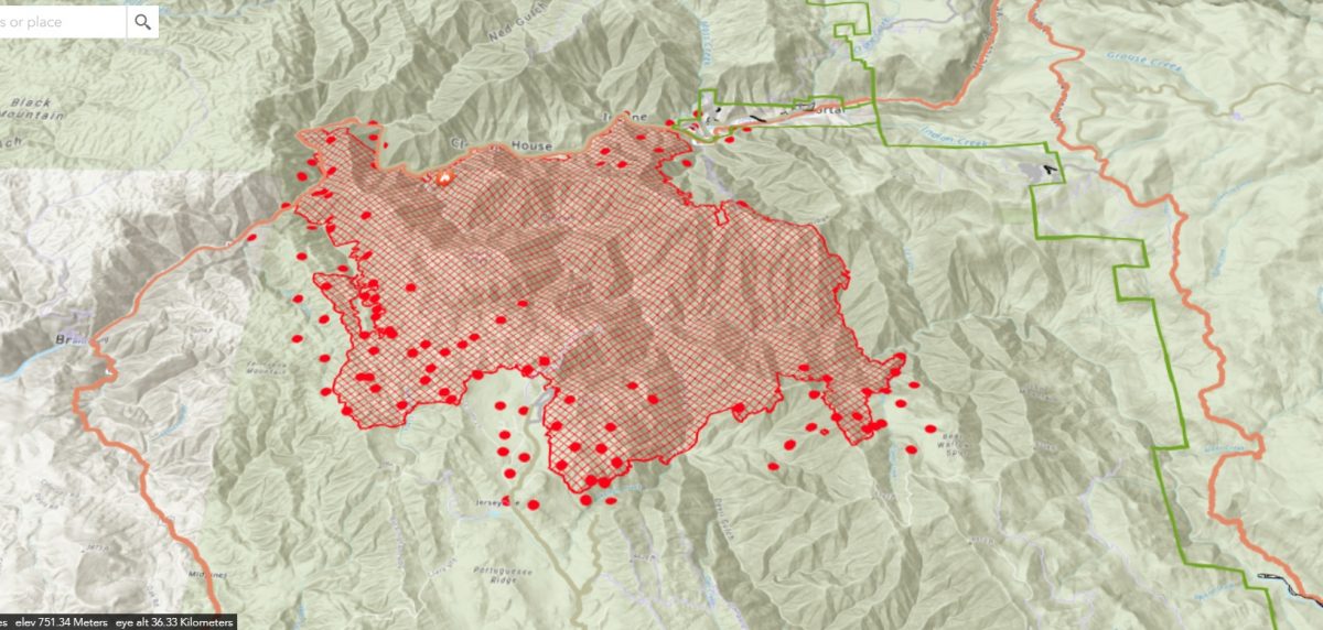
MARIPOSA COUNTY – The Ferguson fire remained active overnight and is now estimated at 22,892 acres and remains at 7 percent containment.
There was active fire behavior along Highway 140 in the dogleg of the Merced River west of Cedar Lodge, and also west of Pinoche Ridge and on the southeastern corner near Granite Ridge.
Crews working along the highway continued to bring fire slowly down to the road, successfully strengthening lines on the south side of the Merced River. The fire has remained on the south side of the river.
Firefighters worked on the primary containment line on the east side of the fire along Henness Ridge. This line is expected to be completed today. Firefighters working on “indirect” lines (built away from the fires active edge) around the community of Jerseydale also made good progress overnight.
Crews will work today to complete indirect lines and to monitor and take suppression action as the fire approaches the Highway 140 corridor, and also the communities of Yosemite West and Jerseydale. They will also scout opportunities for containment of the southeastern side of the fire, where terrain and lack of roads make access difficult.
Thunderstorms remain in the forecast for the next few days, which can produce gusty outflow winds.
As of this morning, no structures have been damaged or destroyed. No additional evacuations were ordered overnight.
There are currently 2,711 personnel assigned to the incident including 203 engines, 58 crews, 41 dozers, 39 water tenders, 16 helicopters, and fixed-wing aircraft as conditions allow.
We will report on details of the day’s activity on the fireline after this evening’s briefing.
There will be two community meetings on the Ferguson Fire today. The first will be held at the Wawona Community Center, 7925 Chilnualna Falls Road from 3 to 4 p.m. The second meeting will be held from 6:30 to 7:30 p.m. at the Mariposa County Fairgrounds, Building A.
The Unified Commanders – US Forest Service, Cal Fire, and Mariposa County Sheriff’s Office, along with the National Park Service – will discuss the current situation of the Ferguson Fire. Officials will be giving a briefing highlighting the current actions that firefighters are taking on the fire.
Current maps of the fire will be available, as well as other handouts. Agency officials will also be available to answer questions. Please arrive early as the meeting will start promptly at the times given. If you have questions about the meetings, please call the Ferguson Fire Info Line at (530) 377-6221.
The community meeting in Mariposa will be live streamed via Mariposa County Sheriff’s Office Facebook page at https://www.facebook.com/mariposacountysheriff
There are currently 216 structures threatened by the Ferguson Fire.
There have been two firefighter injuries reported. There has been one fatality on the fire.
The Incident Command Post for the Ferguson Fire is now at the Ahwahnee Hills Regional Park. Please be aware of heavy fire equipment moving through the area.
The fire is under Unified Command with Cal Fire, U.S. Forest Service, Yosemite National Park and the Mariposa County Sheriff’s Office. Management of the fire transitioned to a Type 1 Management Team – California Team 4 on Thursday.
The Glacier Point Road inside Yosemite National Park was closed at 10 p.m. last night. Firefighting resources and activities involved in the Ferguson Fire have necessitated the need for a small base camp located at the Yosemite Ski and Snowboard Area (formerly Badger Pass) and Bridalveil Creek Campground (which is also closed).
Though the west entrance (El Portal) to Yosemite National Park on Highway 140 is closed, the park remains open. For information on Yosemite National Park, go to nps.gov/yose or call 209-372-0200.
The Ferguson Fire started on Friday, July 13, at 8:30 p.m. The cause remains under investigation.
Smoke from the Ferguson Fire is impacting the Mariposa County Air Pollution Control District and across the region. For information specific to Mariposa County visit http://www.mariposacounty.org/index.aspx?NID=1434. For additional information on air quality you can visit the AirNow website or the air fire smoke page.
Smoke is also affecting air quality in locations throughout the northern and central San Joaquin Valley, prompting local air pollution officials to issue a health cautionary statement for Stanislaus, Merced, Madera, Fresno, and Tulare Counties. Smoke impacts will continue until the fire is extinguished.
Smoke from the fire can cause serious health problems including lung disease, asthma attacks and increased risk of heart attacks and stroke. Where conditions warrant, people with heart or lung disease should follow their doctors’ advice for dealing with episodes of particulate exposure. People with existing respiratory conditions, young children and elderly people are especially susceptible to the health effects from these pollutants. Anyone being exposed to poor air quality or wildfire smoke should move inside to an air-conditioned environment.
Please be advised that the San Joaquin Valley Air Pollution Control District’s Real-time Air Advisory Network (RAAN) monitors are designed to detect the fine particulates (called PM2.5 which are microscopic in size and not visible to the human eye) that exist in smoke. Ash particles are much larger in size and will not be detected by our monitors. Therefore, an area may be experiencing ash impacts from potential fires while the PM monitor reflects a moderate reading. If you can smell smoke or see ash that is an indication that you should be treating air quality conditions as “Unhealthy” (RAAN Level 4 or higher) and remain indoors.
Residents can check the District’s wildfire page at www.valleyair.org/wildfires for information about any current wildfires and whether they are impacting the Valley. The District’s Real-time Air Advisory Network (RAAN) provides localized air quality data from an extensive air-monitoring network which allows Valley residents to track PM at any Valley address by visiting myraan.com.
Residents can also follow air quality conditions by downloading the free “Valley Air” app, available in the Apple store or Google Play.
To sign up for the Mariposa Sheriff’s Office Emergency Alert System visit https://local.nixle.com/register
To register for email updates for the Ferguson Fire Information visit www.tinyurl.com/fergusonfire
For additional information on returning home after a wildfire, go to http://www.readyforwildfire.org/After-a -Wildfire
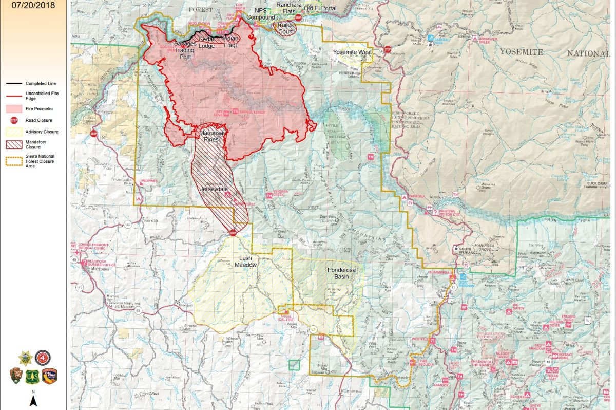
Evacuations
Mandatory evacuations are in place for:
- Savage Trading Post
- Redbud Lodge
- Cedar Lodge
- Indian Flat Campground
- Mariposa Pines
- Sweetwater Ridge
- Ferguson Ridge
- Jerseydale including all residences on Jerseydale Road, Hites Cove Road and all side roads from Triangle Road to the end of Hites Cove Road
- Incline Road from Clearing House to the Foresta Bridge in El Portal
- The BLM campgrounds in Briceburg are closed until further notice
- El Portal Trailer Park
Advisories have been issued for the following locations:
- National Park Service El Portal Complex
- Rancheria Flat – Government Housing
- Old El Portal
- Lushmeadows Community
- Ponderosa Basin Community
- Triangle Road from Jerseydale Road to Highway 49 South including all side roads
- Darrah Road from Triangle to Sherrod Road
- East side of Highway 49S from Darrah Road to Harris Cutoff Road – This includes Boyer Road, Woodland Area, Wass Road and Tip Top Road
- Yosemite West
These areas are NOT under a mandatory evacuation order. This is an advisement only of a potential evacuation order should conditions change.
Should these areas come under a mandatory evacuation order you will be notified via the Sheriff’s Office Emergency Alert System by text, email and a voice call, the Mariposa County Sheriff’s Office Facebook page, and door-to-door communication by Sheriff’s Office staff. At that time you will be notified of the best routes of travel to safely evacuate your residence.
A Red Cross Evacuation Center has been established at the New Life Christian Church located at 5089 Cole Road in Mariposa. If you have been evacuated due to the Ferguson Fire, the Sheriff’s Office asks that you please check in with the Red Cross Shelter even if you do not plan to stay there.
If you are in a Mandatory Evacuation or Advisory Area and may require assistance with evacuation transportation due to special needs or medical issues, please contact Human Services toll free at 1-833-423-0816 as soon as possible.
Planning ahead will help with a safe and timely evacuation.
Animal Evacuation Centers
Small Animal Shelter is at SPCA of Mariposa County, 5599 Highway 49 in Mariposa.
Large Animal Shelter is at the Mariposa County Fairgrounds, 5007 Fairgrounds Road in Mariposa.
Road Closures
Also closed are Jerseydale Road, Hites Cove Road and all side roads from Triangle Road to the end of Hites Cove Road; River Road from Briceburg to the gate at Railroad Flat and all campground areas are closed; Hites Cove Road from Bear Clover Road to the Merced River.
Cooperating Agencies include the Mariposa County Sheriff’s Office, CAL OES, California Highway Patrol, Caltrans, California Department of Corrections and Rehabilitation, American Red Cross, National Weather Service, California Conservation Corps, BLM and additional agencies throughout the state.