YOSEMITE – Sept. 18, 2020 – There are multiple fires burning in Yosemite National Park. Each fire is burning in the Ansel Adams Wilderness, in a fire adapted ecosystem. There are multiple trail closures in effect around Yosemite Creek and the southern part of the park.
All fires may be visible from Tioga Road (Highway 120 through Yosemite National Park), Glacier Point, and high country vistas. Smoke from each fire is settling locally at night and in the morning, then rising and dispersing to the north and northeast in the early afternoon.
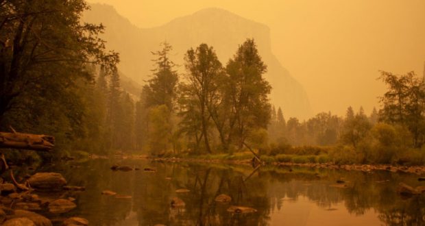
Park managers are working with the local Air Quality Districts to monitor smoke impacts to the park and local communities. Heavy smoke from the Creek Fire continues to impact the area resulting in the closure of Yosemite National Park until Sept. 25, 2020 at which time the conditions will be re-evaluated.
Blue Jay Fire
Location: 4 miles south of White Wolf Campground and 1 mile west of Lukens Lake Trail at approximately 9,000 feet elevation.
Discovery Date: July 24, 2020
Size: 4,061 acres
Containment: 40%
Strategy: Confine and Contain
Cause: Lightning
Activity has diminished substantially due to cooler weather conditions and smoke inversion in the area. Primary direction of growth is to the north and northwest from Tioga Road at McSwain Summit. Spotting north of Tioga Road is smoldering and creeping, with occasional small group torching. Fire crews are utilizing Unmanned Aircraft Systems (UAS) for aerial reconnaissance and mapping, Infrared Detection (IR), and aerial ignition. This type of aerial ignition aids fire personnel by gaining depth along natural containment lines in areas that firefighters cannot access on foot.
inciweb.nwcg.gov/incident/6888/
Wolf Fire
Location: 1 mile north of White Wolf Campground and 2 miles east of Lukens Lake Trail at approximately 9,000 feet elevation.
Discovery Date: August 11, 2020
Size: 900 acres
Containment: 25%
Strategy: Confine and Contain
Cause: Lightning
The fire has a 30% active perimeter, primarily on the southeastern edge. The fire is burning in dense pockets of vegetation and accumulated dead and down logs and is creeping along the forest floor, with some isolated single tree torching and short range spotting along the active perimeter.
inciweb.nwcg.gov/incident/7134/
North Whizz Dome Fire
Location: 4/10 mile south of Cathedral Creek and 1 mile northwest of Tioga Road at approximately 8,400 feet elevation.
Discovery Date: August 27, 2020
Size: 85 acres
Containment: 0%
Strategy: Monitor
Cause: Lightning
The fire has a 50% active perimeter burning in heavy fuels through ground litter on the forest floor and burning in pockets of accumulated dead and down logs with some isolated single tree torching. Fire personnel will continue to monitor fire behavior and growth.
inciweb.nwcg.gov/incident/7135/
Horse Fire
Location: Horse Ridge, 1 mile southeast of Ostrander Lake at approximately 9,500 feet elevation.
Discovery Date: August 24, 2020
Size: 23 acres
Containment: 0%
Strategy: Monitor
Cause: Lightning
The fire is creeping and smoldering through sparse vegetation in a very rocky area. There are currently no threats to trails or infrastructure. Fire personnel will continue to monitor fire behavior and growth.
https://inciweb.nwcg.gov/incident/7149/
Yosemite Fires Web Map
Fire Update Printable PDF
Yosemite Fires Map Printable PDF
Air Quality: Yosemite Air Quality Page or airnow.gov or airnow.gov/fires
Sign-up for Alerts: go.nps.gov/alert

