
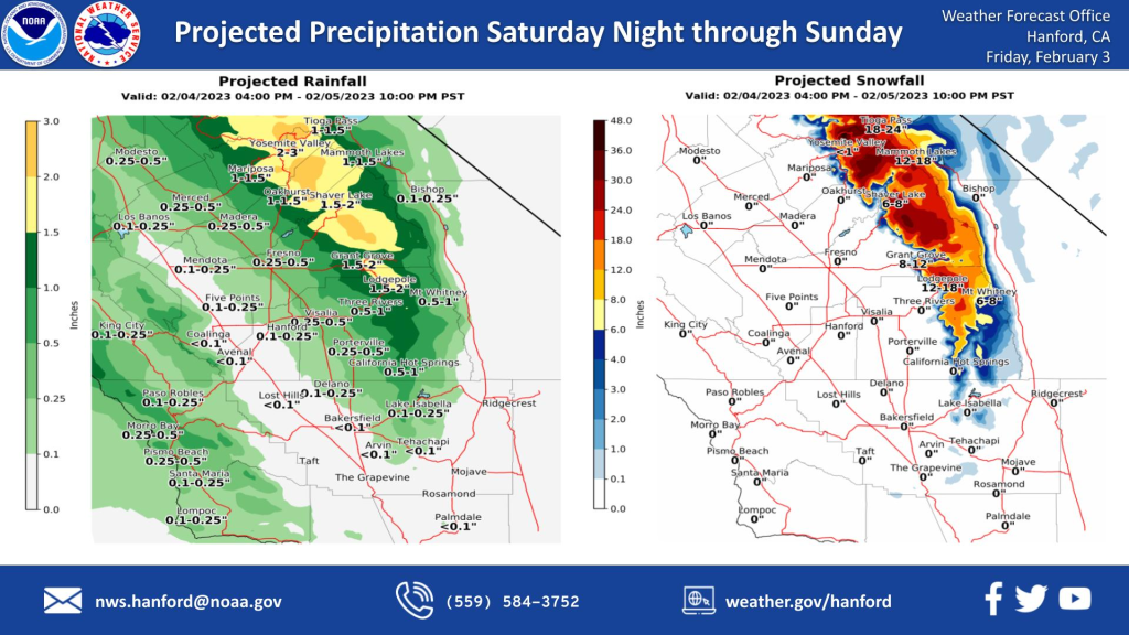
MOUNTAIN COMMUNITIES—The National Weather Service Hanford office is predicting more winter weather will return to our area this weekend. The next storm system will impact Central California Saturday night through Sunday, resulting in the snow in the Sierra Nevada and rain in the San Joaquin Valley. Snow levels will start at around 6,000 feet Saturday night before dropping to about 4,000 feet by Sunday evening. The majority of the precipitation will fall late Saturday night into Sunday morning.
The next storm is now approaching the West Coast and is expected to hit Northern California today. Regional Doppler radar shows the precipitation moving ashore over Northern California and moderate precipitation just off the California Coast. The track of the precipitation is pushing it northeast as Merced County and Yosemite have a slight potential of observing measurable precipitation today. Otherwise, the bulk of todays storm will focus on Northern California before the storm diminishes later tonight.
 Afterward, the next storm to hit Central California will push into the area late Saturday night and into Sunday. While not a major precipitation producer, the next storm will have its origins in Atmospheric River territory. The heaviest precipitation over Central California on Sunday morning is predicted to reach over one inch. Total precipitation values could reach 1.5 to 2 inches, while the lower elevations will see a quarter to half of an inch of rain.
A Winter Storm Watch is in effect for the Sierra Nevada from 10 PM PST Saturday night through 10 PM PST Sunday night. A Winter Storm Watch means there is potential for significant snow accumulations that may impact travel. Snow levels will start at around 6,500 feet Saturday night before dropping to about 4,000 feet by Sunday evening. The majority of this snow will fall late Saturday night through Sunday morning. Winds may gust as high as 55 mph on exposed ridgetops and near the crest.
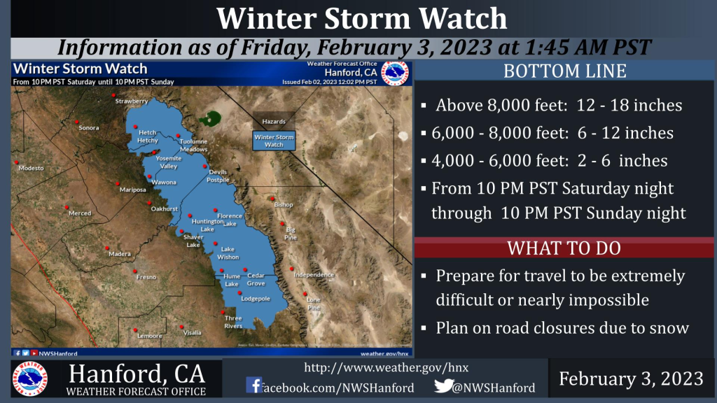
Travel could be extremely difficult or impossible. If you plan to travel, consider alternate strategies. If you must travel, remember to carry tire chains, plenty of food, a good deal of water, warm clothing, and a flashlight in your vehicle.

