MOUNTAIN COMMUNITIES—The National Weather Service Hanford Office predicts a series of storm systems will impact Central California from the middle of the week into the upcoming holiday weekend, producing periodic precipitation. The strongest in this series of storm systems is expected to occur Friday night and Saturday as another atmospheric river could move over Central California.
Starting Monday
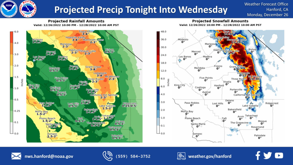
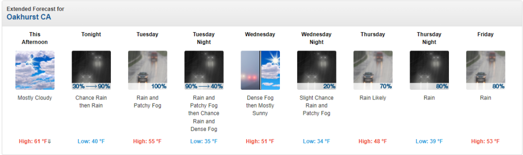
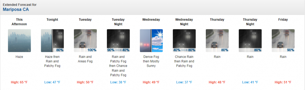
A trough of low pressure will move eastward this afternoon and tonight. Precipitation ahead of this trough of low pressure will overspread Central California late tonight into Tuesday morning. Most precipitation associated with this storm system will fall Tuesday afternoon and Tuesday evening as an atmospheric river moves southward through Central California. Southeast to south wind gusts near 35 mph is possible in the northwestern portion of the San Joaquin Valley and Coastal Range Tuesday.
San Joaquin Valley
One-half of an inch to one inch of rain is possible in the western portion of the San Joaquin Valley, and one inch to one and one-half of an inch of rain is conceivable in the central portion of the San Joaquin Valley. One-and-one-half of an inch to two inches of rain is possible in the eastern portion of the San Joaquin Valley tonight through Wednesday morning. This rainfall could lead to nuisance flooding, especially Tuesday afternoon and Tuesday evening, when rain rates will be highest.
Foothills
Two to four inches of rain is possible in the Sierra Nevada foothills tonight through Wednesday morning. Three to four inches of rain is conceivable in the Sierra Nevada below 6,000 feet tonight through Wednesday morning. This rainfall could result in rockslides in canyons and steep hillsides, mainly Tuesday afternoon and Tuesday evening, when rain rates will be highest.
Sierra Nevada Mountains
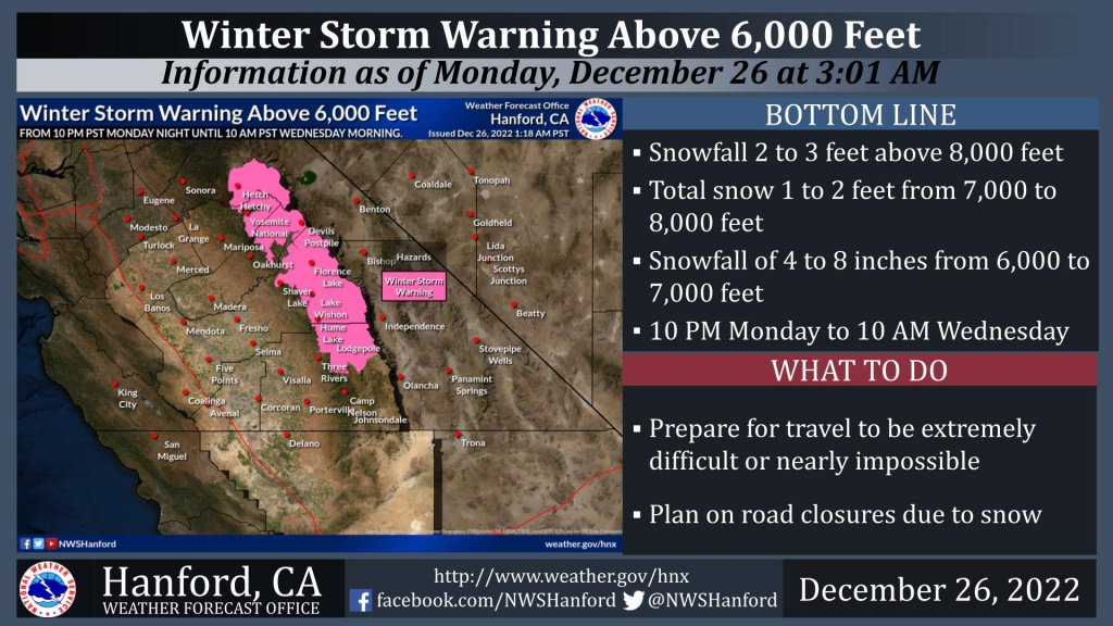
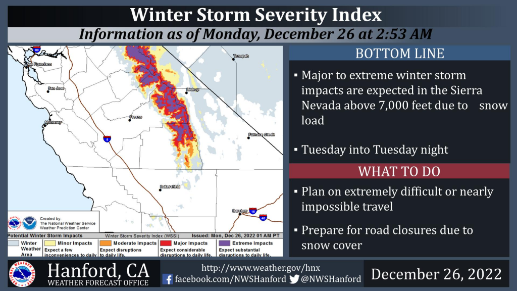
A Winter Storm Warning is in effect for the Sierra Nevada above 6,000 feet from 10 PM PST tonight until 10 AM PST Wednesday morning. Two to three feet of snow is expected above 8,000 feet. One to two feet of snow is anticipated from 7,000 to 8,000 feet. Four to eight inches of snow is expected from 6,000 to 7,000 feet. The snow will start at around 8,000 feet tonight before falling to about 7,000 feet Tuesday night. The snow level will drop to around 6,000 feet Wednesday morning. Significant to extreme winter storm impacts are expected above 7,000 feet Tuesday and Tuesday night due to snow load. Winds will gust as high as 55 mph on exposed ridgetops and along the crest. These solid and gusty winds may cause significant tree damage.
Looking Toward The Holiday Weekend
A series of storm systems will impact Central California from mid-week to the upcoming weekend, producing periodic precipitation. The strongest in this series of storm systems looks to occur Friday night and Saturday as another atmospheric river could move over Central California.
Local community residents are encouraged to be prepared for traffic hazards, closed roads, and power outages. Sierra News Online will be here monitoring and reporting on conditions in Mariposa County and Eastern Madera County. More information on being prepared for power outages can be found here.

