MOUNTAIN AREA — A Winter Storm Watch issued by the National Weather Service (NWS) in Hanford is in effect as forecasters say a pair of Pacific weather systems are set to arrive in the mountain area this weekend, bringing “significant late season snowfall” to the high country.
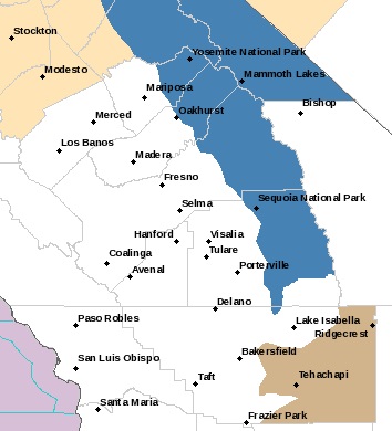
The blue section highlights the Winter Storm Watch areas
The NWS weather advisory covers the Sierra foothills and mountain areas from Tulare County north through Yosemite and is in effect until 6 p.m. Monday.
The advisory includes eastern Madera County and Mariposa County.
A Winter Storm Watch means there is potential for significant snow, sleet or ice accumulations that may impact travel.
The initial storm, expected to arrive late Saturday, will bring periods of snow to areas between 4,000 and 5,000 feet. Expected amounts will range from 4 to 8 inches ahead of a stronger system set to drop heavier snowfall on Sunday. One to 2 feet of snow of additional snow is likely with the second system, “leading to periods of mountain travel impacts.”
“For those who must travel, expect chain controls, snow-covered roads, poor visibility, and significant travel delays,” warns the NWS.
Snow showers are expected to continue into Monday, with snow levels lowering to 3,000 to 4,000 feet.
“Storm total snow amounts will likely range from 1 to 2 feet, locally up to 3 feet in some locations,” said the NWS bulletin.