FRESNO — Pacific Gas and Electric Company (PG&E) is cautioning those who live or work near rivers and streams to be aware of higher flows brought on by recent rains and potentially spilling reservoirs.
It is possible that PG&E’s Bass Lake/Crane Valley Dam will reach spill levels Wednesday or Thursday as heavy warm rains melt recent snowfall.
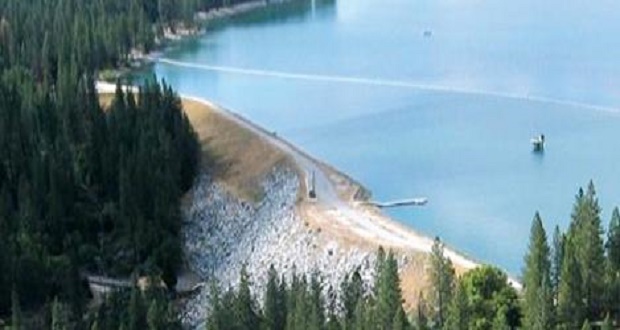
Currently the water level at Bass Lake is at 3,364.23 feet of elevation, says PG&E. The spill gates are located at 3,365.7 feet, and inflows are slowly increasing.
“It’s not unusual for PG&E‘s reservoirs to spill during the wettest parts of normal winters, because they tend to have less storage and are located at much higher elevations than state and federal multi-year water storage reservoirs like Millerton Lake and Pine Flat,” says PG&E spokesman Denny Boyles.
“PG&E’s reservoirs are designed to capture rain and snow melt runoff in winter, spring and early summer to generate clean, renewable hydroelectric power.”
Water Safety Tips –
- Sudden immersion in cold water can stimulate the “gasp reflex,” causing an involuntary inhalation of air or water. It can even trigger cardiac arrest, temporary paralysis, hypothermia and drowning. When faced with swift water, even the strongest swimmers may be easily overwhelmed.
- Cold water entering the ear canal can cause vertigo and disorientation. This may confuse swimmers, causing them to venture deeper into the water.
- Recreating in PG&E canals and flumes is strictly prohibited. Stay out of canals and flumes, which are very dangerous due to slippery sides and fast moving water.
Flood Watch
A Flood Watch is in effect for the foothills of the Sierra Nevada from Yosemite to Kings Canyon and Tulare County Mountains, from 4 a.m. on Wednesday, Feb. 13 through 10 a.m. Thursday, Feb. 14. This includes the Mariposa, Madera, and Fresno County Foothills, the Tulare County Foothills, and the Kern County Mountains.
A Flood Watch means there is a potential for flooding based on current forecasts.
The Flood Watch reaches the towns of Bass Lake, Coarsegold, Fish Camp, Mariposa, North Fork, Oakhurst, Tuolumne Meadows, and Wawona, as well as Squaw Valley, Auberry, Springville, Three Rivers, Tehachapi, Lake Isabella, Devils Postpile, Florence Lake, Lake Thomas Edison, Camp Nelson, Giant Forest, Lodgepole, Grant Grove, and Johnsondale.
Light to moderate rain will begin this evening, Tuesday, Feb. 12. Heavy rain will hit the area Wednesday afternoon and persist through Thursday morning. Rain on top of snow will potentially create flooding concerns in the Southern Sierra Nevada below 5,000 feet.
Rivers and streams will rise on Wednesday as rain increases through the day. Street flooding and mudslides are also possible in foothill communities.
Monitor the latest forecasts and be alert for possible Flood Warnings. Those living in areas prone to flooding should be prepared to take action should flooding develop.
Winter Storm Warning
The NWS has issued a Winter Storm Warning for the Sierra Nevada from Yosemite to Kings Canyon and Tulare County Mountains above 5,000 feet, beginning at 4 a.m. on Wednesday, Feb. 13 and in effect through Thursday evening, Feb. 14.
A Winter Storm Warning for snow means severe winter weather conditions will make travel very hazardous or impossible. If you must travel, keep an extra flashlight, food and water in your vehicle in case of an emergency.
Heavy snow is possible above 5,000 feet. Total snow accumulations of up to 1 foot possible from 5,000 to 7,000 feet, 1 to 3 feet from 7,000 to 8,000 feet, between 3 to 5 feet above 9,000 feet, with the possibility of up to 7 feet of snow expected. Winds could gust as high as 70 miles per hour above 9,000 feet.
Continue to monitor the latest forecasts for the most up-to-date information.
Travel could be very difficult to impossible. The hazardous conditions may impact the morning and evening commute. Very strong winds could cause cause extensive damage to trees and power lines.


http://basslakeca.com/lake.html indictes the full elevation of Bass Lake is 3376′ 8″. Why is there a disparity between 3365.7′ and the full elevation of 3376′ 8″. I am sure there is an explanation. Can anyone explain the distinction between the two levels?