Home » Search Results for: yosemite fires (page 19)

Search Results for: yosemite fires

Washburn Fire Managers Report 31% Contained

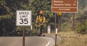
YOSEMITE NATIONAL PARK–The Washburn Fire is currently burning within the Yosemite National Park (YNP) boundary near the Mariposa Grove area. The Mariposa Grove is closed indefinitely. The community of Wawona has been evacuated including residents, employees, and park guests. The southern entrance to YNP via Highway 41 through Oakhurst is closed. The majority of YNP is open and can be accessed ...

Read More »

Hiking Through Mariposa Grove Up To Wawona Point

Hiking beside really old, tall trees that have tiny cones is always special and a bit of Galen Clark’s cabin history along the way made it even better. It had been a while since I had hiked in Mariposa Grove and I got an early start to beat the crowd. And you probably should be careful when you tell me ...

Read More »

Prep for Fire Season With Defensible Spaces Around the Home

Image of someone weed whacking.

MOUNTAIN COMMNUNITIES — Yosemite National Park Service and the U.S. Department of the Interior want you to prepare for what is very likely to be a long and dry summer. There are many steps you can take NOW to prepare your home for the upcoming fire season. Consider the following ways you can protect you and your family this summer, such ...

Read More »

A Complete Guide to Residential Pile Burning

Image of a burn pile.

MOUNTAIN COMMUNITIES — Attention local residents, if you are taking the opportunity to conduct safe residential pile burning, please refer to the attached guidance related to timing and notifications of your burn. We know this is a great way to reduce fire hazards around your home and want to ensure you have the best information on hand. For more details ...

Read More »

Hiking From Briceburg up the Burma Grade to the Gate

It was a little early for Merced River Canyon’s wildflower show but the right time to get in a good winter conditioning hike with some miles and a climb along the Merced River at Briceburg. Where: Bureau of Land Management (BLM), Merced River Recreation Management AreaDistance: 10.6 miles roundtrip but you can go shorter or longerDifficulty: Moderate to StrenuousElevation Range: ...

Read More »

YGP’s Virtual Winter Quarterly Meeting

Yosemite – The January Quarterly meeting will be a conversation with public land managers from California State Parks, Bureau of Land Management, US Forest Service as well a speaker/volunteer leader from Recreate Responsibly California Coalition. 9:30 a.m. – Community Open Mic Chat 10:00 a.m. – Main Meeting Topic 11:00 a.m. – Yosemite National Park Update The past 20 months through ...

Read More »

Hiking From Tuolumne Meadows To Dog Lake

Smoky reflections in a lake named for a sheepdog and her puppies, Sierra Nevada yellow-legged frogs, fishless lakes, and Tuolumne Meadows Campground’s closure played starring roles in my blog this week. Where: Yosemite National ParkDistance: 5.76 Miles (About 5.2 Miles from the trailhead at the parking lot up to and around the lake)Difficulty: Easy to ModerateElevation Range: 8,583′ – 9,189′Elevation ...

Read More »

Hiking Up Ten Lakes Trail to Grant Lakes

Hiking to a pretty lake never gets old, especially when it reflected the surrounding mountains in its crystal clear water and I had the lake to myself. Where: Yosemite National ParkDistance: 12.35 MilesDifficulty: Moderate to StrenuousElevation Range: 7,490′ – 9,635′Elevation Gain: 2,590′Date: September 2, 2021CALTOPO: Grant Lakes HikeDog Hike? NoLeaving the house early, I headed into Yosemite National Park via ...

Read More »

At the Forks Resort, You’re Family

BASS LAKE — There’s no two ways about it. When you’re at The Forks Resort on beautiful Bass Lake, you’re family. If you’re not Ron and Leslie Cox, current owners of the property (for “only” 40 years) or their children, Adam and McKenzie, you become family by association. Many of their employees have been with the Coxes for decades, some ...

Read More »
Sierra News Online

Sierra News Online