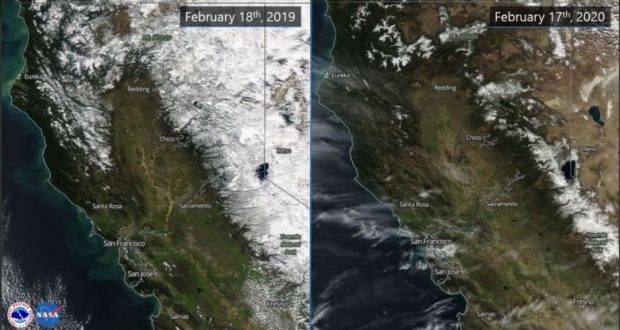
MOUNTAIN COMMUNITIES — NASA satellite images taken this past week from more than 400 miles above Earth show snow pack levels in the Sierras at just 54 percent of their historical average for this time of the year.
The most recent data is sparking concerns that parts of California are slipping back into a drought — and that the 2020 fire season could begin much sooner.
“Forested areas, especially those with a lot of dead trees, will dry out much sooner without as much snow pack or runoff when the warmer weather comes,” warned one fire official. “We could be looking at a very active 2020 fire season in the Sierra.”
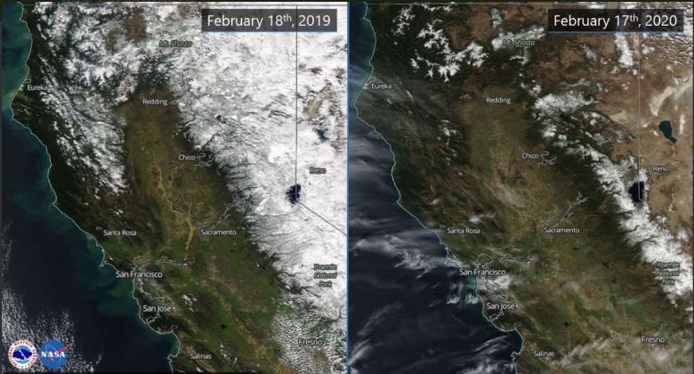 The recent NASA photos provide a clear indication of how much less snow has fallen over the Sierras this winter compared to last. At this time in 2019, the Sierra snow pack was at 147 percent of its historical average, according to the National Weather Service.
The satellite images captured last week show the northern Sierra is currently at 58 percent of its historical average while central Sierra snow pack levels, which include Madera and Mariposa counties, is at 54 percent of the historical average and the southern Sierra currently sits at just 49 percent of average.
With six weeks still remaining in California’s traditional winter season, forecasters say any new storms, especially heavy ones, could boost the snow pack totals closer to annual averages.
But as of this week, forecasts are calling for the dry weather to continue through the end of February across much of the state.
“What a difference a year makes!” forecasters at the National Weather Service in Sacramento said on Twitter while posting the most recent satellite images.
According to the U.S. Drought Monitor, less than half of normal precipitation has fallen from central and southern Nevada westward across most of California since mid-December. Last week, just under 10 percent of the state, including the central and southern Sierras and adjacent areas of the Central Valley, was designated as being back in “moderate” drought conditions.
After a wet December, many parts of the Sierra are seeing their driest combined January and February on record, forecasters say.
The California Department of Water Resources took its most recent Sierra snow pack measurements on Feb. 20. The next snow pack measurement date is scheduled for April 1.