
MIDPINES — The Oak Fire started Friday, 7.22.2022, in the Midpines area of Mariposa County near Carstens Road and Highway 140. It has burned more than 14,000 acres. Over 2000 structures are threatened by the fire and approximately 5,000 people have been evacuated or are on an evacuation warning. Emergency personnel are working to safely evacuate people and are actively engaged in protecting structures. We will update this article as more information is available. Helpful links are available at the end of this article.
A community meeting has been scheduled for Sunday, 7.24.2022, at 7:00 pm in the Mariposa County High School Gymnasium at 5074 Old Highway N in Mariposa. Sierra News Online will be livestreaming the meeting (live stream will be available based on quality of internet service).
OAK FIRE INFORMATION LINE – 844-668-3473
Update 10:00am 7.25.2022

Oak Fire Operations Map 7.25.2022
Update 7:45pm 7.24.2022
The Oak Fire is currently 15,603 acres with 0% containment. There are over 3200 structures threatened.
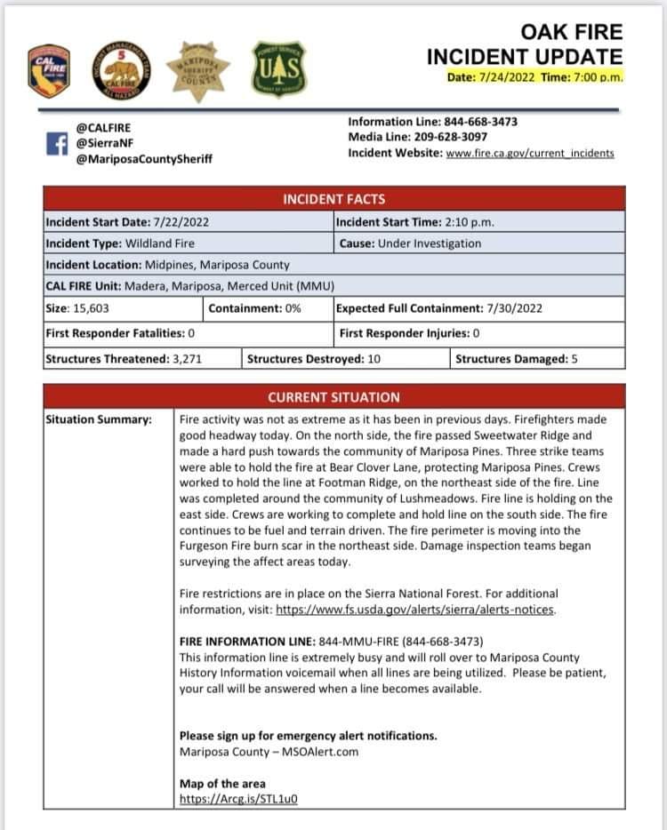
Oak Fire Incident Sheet 7pm 7.24.2022
Update 2:30pm 7.24.2022
New Evacuation Advisements have been issued.
-Hwy 49S from Triangle Rd to the Madera County Line including all side roads
This includes: Watt Road, Watt Road Extension, Harris Road Kimble Road and all side roads
-Hwy 140 from Ponderosa Way to Briceburg both sides of the road
-Colorado from Hwy 140 to East Whitlcok
-Rancheria Creek Road
-Davis Rd
-Wilderness View Rd
-Rumley Mine Road
-Grojean Rd from Hwy 140 to Foran Road including all side roads
-Foran Rd to East Whitlock
-East Whitlock from Foran to Hwy 140 including all side roads
-Devils Gulch to Signal Peak Area including Chowchilla Mountain Road
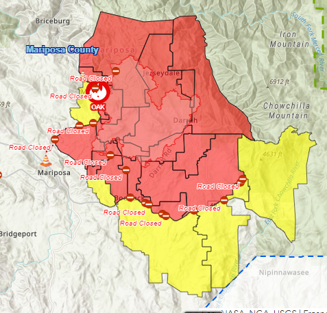
Map of the affective area
A Fire advisement is NOT an evacuation Order, it is simply to advise residents in the area of the potential need to evacuate should conditions change. Allowing those in the affected area to plan and prepare.
Update 1:00pm 7.24.2022
Cal Fire has posted a video update.
New Evacuations have been added.
EVACUATION ORDER ISSUED FOR THE FOLLOWING AREAS:
Oak Fire Evacuation Map Afternoon 7.24.2022
Carlton Road from Morningstar to Silva Rd including all side roads
Silva Rd from Carlton to Hwy 49S including all side roads
Shaffer Road from Silva Rd to Allred Rd
Hwy 49S from Silva to Darrah Rd (on the Bootjack Market Side)
To evacuate please use Carlton/Silva Rd to Hwy 49S
Hwy 140 from Triangle Road to Ponderosa Way (on the Midpines Market side of Hwy 140)
Ponderosa Way from Hwy 140 to Feliciana Mountain Rd and all side roads
Sweetwater Ridge / Mine area
Feliciana Mountain Road
Ferguson / Apperson Mine Road area
Savage Lundy Trail
Hites Cove Road
Footman Ridge area
Devils Gulch area
Map of the affected area.
An Evacuation Shelter has been established at the Mariposa Elementary School located at 5044 Jones Street, Mariposa
If you need immediate emergency assistance please dial 911, if you need assistance with large animals please call 209-966-3615
Large Animals can be taken to the Mariposa Fair Grounds.
Small Animals can be taken to the Red Cross Shelter located at Mariposa Elementary School.
CURRENT SITUATION

Oak Fire Power Outages Map 7.24.2022
The Oak Fire has burned 14,281 acres and is 0% contained. The fire was very active overnight and burned an additional 500 acres. 2,400 residents of Mariposa County are currently without power due to the fire. Pacific, Gas and Electric Company (PG&E) has no estimated date of restoration at this time. The power outages are caused both by the fire damaging equipment and fire managers requesting power lines be de-energized in areas that may be impacted by the fire. The Incident Management Team (IMT) took over management of the fire at midnight, after receiving a detailed briefing from Cal Fire and Sierra National Forest managers.
Most recent evacuation orders announced yesterday evening include a fire advisement evacuation order for:
Ponderosa Basin Subdivision
This includes:
All of Chowchilla Mountain Rd and all side roads
All of Harris Cutoff Rd and all side roads
All of Harris Rd and all side roads
5S25 and 4S04
Hwy 49S from Chowchilla Mountain Rd to Harris Rd- on the Chowchilla Mountain Rd side.
*A Fire advisement is NOT an evacuation Order, it is simply to advise residents in the area of the potential need to evacuate should conditions change. Allowing those in the affected area to plan and prepare.
A complete list of evacuation orders and road closures is available on Mariposa Counties Oak Fire Incident web page.
A link to the map is also included in the helpful links at the end of this article.
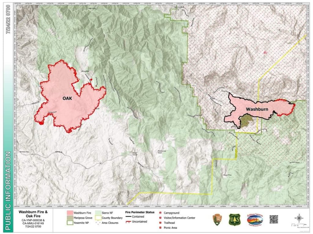
Map of the Oak Fire and it’s proximity to the Washburn Fire 7.24.2022
WHAT CAN WE EXPECT
The fire remained active through the night moving toward the communities of Jerseydale, Darrah, and Bootjack. Poor humidity recovery was observed overnight. Today the weather is expected to remain hot with minimum humidity between 5% and 10%, which will hamper firefighting efforts. High tree mortality and dense fuels are throughout the fire area. Fire evacuation and advisories remain in effect. Damage inspection teams are beginning their assessment of the areas affected by the fire.
The estimated date of containment is 7.30.2022.
RECOVERY AND RELIEF EFFORTS
All evacuee’s are encouraged to register with the American Red Cross and the Federal Emergency Management Agency (FEMA) to be eligible for services.
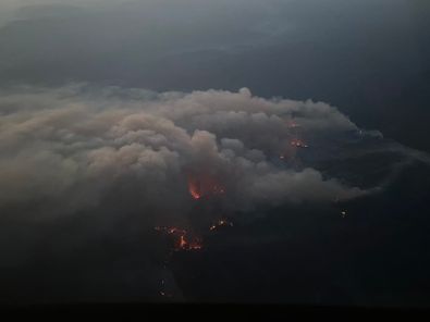
Oak Fire as seen from the air and one of Courtney Aviation’s Fire Mapping aircraft 7.24.2022
HELPFUL LINKS
Mariposa County Sheriff’s Office

