
MOUNTAIN COMMUNITIES—The National Weather Service Hanford Office is predicting an atmospheric river storm will move into our area late Monday night into very early Tuesday morning. Currently, a Winter Storm Watch is in effect for this storm but it will likely be upgraded to a Warning later today. A Wind Advisory will also be in effect for tomorrow.
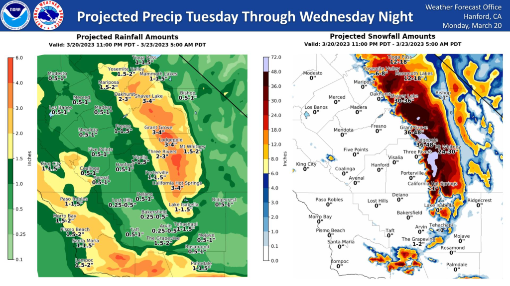
This storm will bring more rain to the San Joaquin Valley Tuesday through Wednesday morning. The Sierra Nevada is looking at 2 to 4 feet of snow for the Southern portions and 1 to 4 feet in the Yosemite and Central portion. This atmospheric river will not be as strong as some of the previous atmospheric river events.
WINTER STORM WARNING IN EFFECT FROM 5 AM TUESDAY TO 11 PM PDT WEDNESDAY
WHAT
Heavy snow is expected. Total snow accumulations of 1 to 4 feet and locally up to 5 feet. Winds gusting as high as 60 mph.
WHERE
Sierra Nevada, mainly elevations 4,000 feet and above.
WHEN
From 5 AM Tuesday to 11 PM PDT Wednesday.
IMPACTS
Travel could be very difficult to impossible. The hazardous conditions could impact the morning or evening commute. Strong winds could cause tree damage. The cold wind chills as low as 20 below zero could result in hypothermia if precautions are not taken.
PRECAUTIONARY/PREPAREDNESS ACTIONS
If you must travel, keep an extra flashlight, food, and water in your vehicle in case of an emergency.
WIND ADVISORY IN EFFECT FROM 5 AM TO 9 PM PDT TUESDAY
WHAT
South to southeast winds 20 to 30 mph with gusts to 45
mph expected.
WHERE
Much of the San Joaquin Valley and the Sierra Nevada
foothills and portions of the Kern County mountains north of
Tehachapi.
WHEN
From 5 AM to 9 PM PDT Tuesday.
IMPACTS
Gusty winds could blow around unsecured objects. Tree
limbs could be blown down, resulting in a few power outages.
PRECAUTIONARY/PREPAREDNESS ACTIONS…
Use extra caution when driving, especially if operating a high-profile vehicle. Secure outdoor objects.
What to Expect Later in the Week
A small ridge moves in Thursday and Friday, providing a break in the rain and snow. However, another weak trough is expected to move in Friday night through Saturday. This trough is polar, and weather models are showing that it will slide down the Great Basin as an inside slider. The inside slider trajectory of this trough raises the possibility of Mono Winds. This trough is currently forecasted to bring snow showers to the Sierra Nevada. However, no rain is expected this weekend inside the slider.

