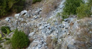
Imagine visiting Yosemite in the 1870s, before Yosemite had been designated a Park. You just might have come into Yosemite Valley on a horse and wagon from Big Oak Flat down into the valley via the Old Big Oak Flat Road. Parts of this old road have been wiped out by rockslides but much of the road is still accessible by foot. ...
Read More »Hiking
Snowshoe Adventure with Sally and Raven at Fish Camp
Sally and Raven headed to Fish Camp to check out the recent snow. We drove them. When we told the dogs it was ok to unload, they were off. They sure love the snow and so do I. We saw some great snow, beautiful reflections in the creek and got a good workout in our snowshoes. Where: Fish Camp, Sierra National Forest ...
Read More »Snowshoeing at Tamarack Ridge
The recent snowfall was inviting us to our first showshoe adventure of the year. Except for the many animal tracks we could see in the snow, we had the place to ourselves. Where: Tamarack Ridge SNO-PARK, Sierra National Forest Distance: 4.8 miles Difficulty: Moderate Elevational Range: 7,446′ to 7,728′ Date: November 12, 2015 Maps: High Sierra Ranger District Winter Recreation Guide, Dinky Creek ...
Read More »Leaf Peeping in Yosemite Valley
We couldn’t wait to get up to Yosemite Valley right after the last storm. We needed to check out the fall colors, reflections in the Merced River, those waterfalls and snow covered trees on the rim. Plus, you never know what special surprise will be in store for us on our adventures. Difficulty: Easy Elevational Range: 3,880′ to 4,960′ Date: November 4, 2015 ...
Read More »Two Photographers, 220 Miles On The John Muir Trail
By Scott Lange — Just after Labor Day we set out to capture night and day on the John Muir Trail, and the journey was a great one. Like many, we chose to begin in Yosemite’s Tuolumne Meadows due to the easier conditions for obtaining a permit, and because we’ve already hiked the valley several times. Departing the day after ...
Read More »Hiking with Sally up to the Hess Mine in the Tioga Pass Area
I had been looking at a dot on the topog map called the Hess Mine for a few years, walking all around that gorgeous area in the Hoover Wilderness and the 20 Lakes Loop Basin. Sally and I decided that it was time for us to walk around that area and learn more the mine and the people behind it. Where: Hoover Wilderness, ...
Read More »Hiking up to Gardisky Lake and Tioga Peak
Fresh snow was calling and the best place I knew of to view snow covered peaks was in the Tioga Pass area. I wasn’t too sure about how much snow was up there, but our plan was to head up to Gardisky Lake then hike up to Tioga Peak to see the view. We had the snow and we had those views! ...
Read More »Hiking with Sally and Raven in Nelder Grove
We were curious if those dogwoods had started turning those beautiful red fall colors yet in Nelder Grove. I could tell the dogs were also looking forward to the adventure! Distance: 6.5 miles (but you can go more or less if you want to) Difficulty: Easy to moderate Elevation Range: 5,242′ – 6,043′ Date: October 5, 2015 Topographic Quad Map: ...
Read More »Leaf Peeping on the East Side: Lee Vining Creek, Lundy Canyon, Dunderberg Meadow, McGee Canyon
We headed over to the east side of the Sierra to check out the fall color. I know, we did the same thing last week, but we went to different areas and found the most beautiful orange aspens to share with you. Distance: About 300 Miles Roundtrip Dificulty: Easy Elevational Range: 7,200′ to 9,960′ Date: September 28, 2015 We drove ...
Read More »Leaf Peeping on the East Side: Tioga Pass Area, Green Creek, Virginia Lakes
What do you do to celebrate the first day of Fall? Head to the east side of the Sierra to check out the early fall color at the higher elevations. We didn’t know what we would find but hoped we would find some Aspens turning their pretty fall colors. Distance: About 300 miles roundtrip Difficulty: Easy Elevation Range: 7,200′ to ...
Read More »