HANFORD–The National Weather Service Hanford Office is predicting that after a brief break from precipitation today, periods of rain and mountain snow will return to central California into early next week. The heaviest rain and snow will occur over the weekend.
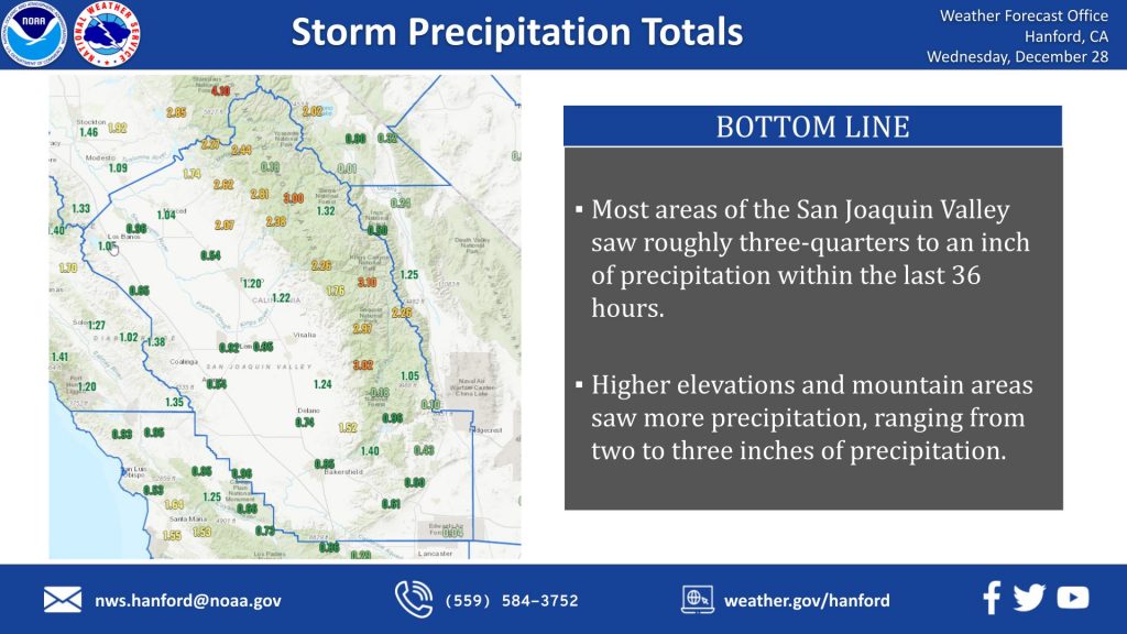 Here is a map showing yesterday’s storm precipitation totals. Most areas of the San Joaquin Valley saw three-quarters of an inch to an inch of precipitation, while higher elevation areas saw 2-3 inches of precipitation.
Midweek
The moisture plume which brought significant rain and high-elevation snow to our area is now shunted south and east, and we are left with just some residual low clouds and fog in the San Joaquin Valley. This will provide a dry and mild day across central California today before another weak disturbance begins to steer another stream of moisture into our region by early Thursday, bringing additional rain outside of desert areas and more mountain snow.
Late Week
Snow levels will start as low as 4000 feet early Thursday with the incoming system but will rise to around 7 to 8 thousand feet by early Friday as the flow becomes more west/southwest ahead of another developing trough. Expect a few tenths to one-half inch of additional Valley rain with an inch to inch and a half in the foothills. The highest elevation snow amounts near 1 foot are likely.
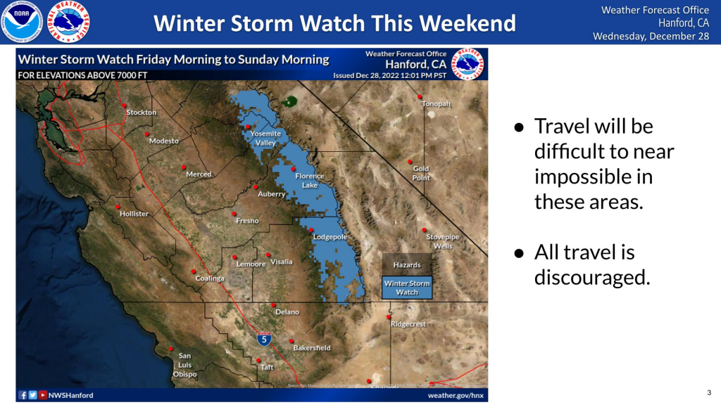
A winter storm watch is issued until Sunday, January 1st, 2022, at 4 am PST. Heavy snow is forecasted for the mountains, and travel will be difficult to near impossible. All travel is discouraged.
The Weekend
As the developing trough approaches Friday into Saturday, another significant atmospheric river episode will impact central California through the weekend. Precipitation amounts for Friday through Sunday range from around 1/2 – 3/4 inch on the west side of the San Joaquin Valley to 1 1/2 – 2 inches farther east and 2 – 5 inches up into the foothills and lower Sierra below the snow line. This will be another high snow level event, with levels around 7500 – 8500 feet until the trough pushes through later Saturday, bringing snow levels down to around 4000 – 5000 ft. Look for total accumulations at the highest elevations up to 3 – 5 feet.
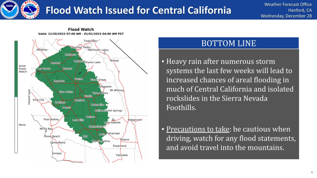 Heavy rain after numerous storm systems in the last few weeks will lead to increased chances of areal flooding in much of Central California alongside rockslides in the Sierra Nevada Foothills. Be cautious when driving, watch for any flood statements, and avoid traveling into the mountains. Check at the end of this article for sandbag locations.
Another brief break will come Sunday into Monday before ensemble model solutions show another system steering additional moisture into our area, providing another round of significant rain and mountain snow.

Sandbag Station Locations
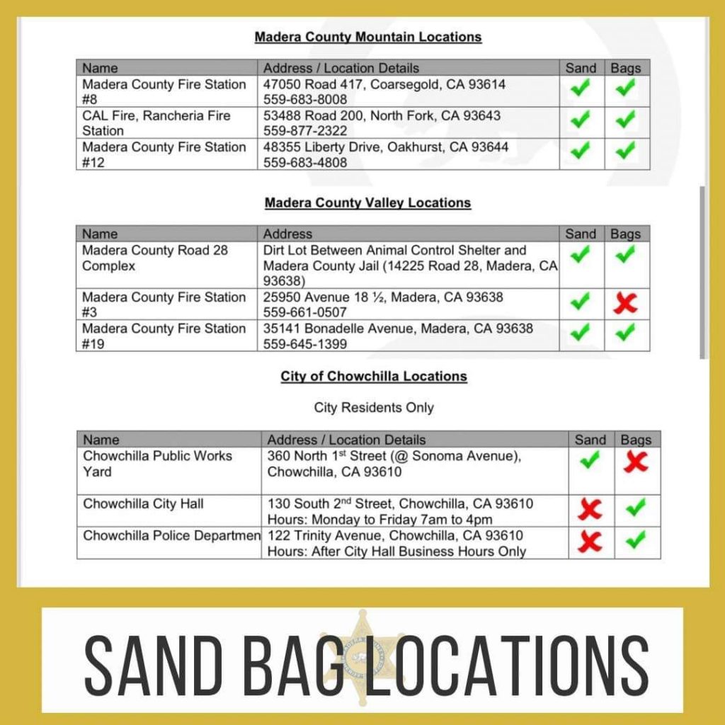 Madera County
Emergency sand and sandbags are available for residents- see attached list. You must provide proof of residence at all locations and bring your own shovels.
The County provides ten bags per resident*. If you need additional sandbags, you may purchase them at a local hardware store.
*Please note- some locations do not have sandbags. Consult the attached list to verify where sandbags are available.
Mariposa County
Sandbags are available at the old Mormon Bar fire station across from the fairgrounds and the Don Pedro water treatment facility behind County Fire station 24. Bags and sand are on-site for self-filling needs; you will need a shovel.

