YOSEMITE NATIONAL PARK–The Washburn Fire is currently burning within the Yosemite National Park (YNP) boundary near the Mariposa Grove area. The Mariposa Grove is closed indefinitely. The community of Wawona has been evacuated including residents, employees and park guests. We will be adding updates to this article , please check back often. Helpful Links are at the bottom of the page.
Update 11:00am 7.13.2022
As of late late morning on day seven, the Washburn Fire has grown to 3,772 acres with 17% containment. The Mariposa Grove of Giant Sequoias remains largely unaffected. The 2,000 year old trees have lived through a multitude of fires; there is a strong hope they will survive this fire unscathed.
Update 9:00pm 7.12.2022
At the end of day six as few as 3,500 acres have burned in the Washburn Fire. Perimeter containment is at 17%. Heavy available fuel loads, seasonally dry timber, and litter contribute to highly active fire behavior in uncontained portions of the fire. Continued warming and drying over the next several days will likely provide increased fire behavior with additional fire growth and smoke production.
Update 11:00am 7.12.2022
The Incident Management Team (IMT) has posted a video update here.
Update 9:00am 7.12.2022
Day six of the Washburn Fire brings the total acres burned to 3,221 and containment at 25%. Fire managers are reporting that the spot fires from yesterday afternoon have all been handled and crews are on task to continue suppression operations from the ground and the air. Highway 41 (Wawona Road) is holding well as a control feature. The fire has not entered Wawona and structure defense crews have put into place defensible spaces including dozer lines, sprinkler systems and clearing of fire fuels. Also, the Beledo Cabin is being prepped and wrapped at this time.
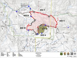
Washburn Fire briefing map for Tuesday, 7.12.2022
A community meeting was held in Oakhurst last night and a video of the meeting is available on the Yosemite Fire and Aviation Facebook page. When officials were asked about the cause of the fire the reply was that they believe the fire was human caused and they are continuing to investigate.
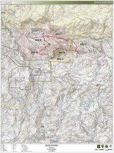
Washburn Fire evacuation map Tuesday, 7.12.2022.
Evacuations remain the same for the Wawona area and are being reevaluated every 24 hours. Highway 41 (Wawona Road) is still closed heading into the park at the south entrance and will remain so until it is deemed safe from the fire.
The weather for the next operation period, July 12, 2022, includes wind speeds at 3-8 mph and gust up to 15 mph. Temperature highs are predicted in the 84-90 range and the relative humidity is expected to be 20-30%.
Over the next 72 hours and beyond we can expect increased warming and drying that will maintain active to very active fire behavior potential. There is likely to be an increase in fire behavior to include group torching, short torching/crown runs, and spotting to .5 miles. A peak warming and drying period late in the week will provide active to very active fire behavior on uncontained portions of the fire.
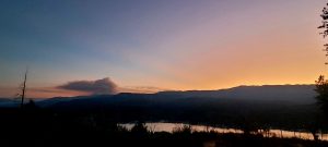
Sunrise on the Washburn Fire Tuesday morning, 7.12.2022.
This morning the fire is already appearing to be very active as seen on the Alert Wildfire cameras. Expect a lot of activity and smoke production. An interactive smoke map is available at fire.airnow.gov/ and allows you to zoom into your area to see the latest smoke conditions.
Previous Day Update
Update 8:00pm 7.11.2022
The Washburn Fire is 2,720 acres with 22% containment currently. Today, significant activity was observed on the northwest and northeast corners of the fire south of the south fork of the Merced River. All of the spot fires reported earlier have been taken care of.
Fire managers objectives right now are to continue direct handline construction where possible and prepare for indirect line when needed. They plan to utilize offensive firing operations along primary control lines when appropriate. They will also continue to defend Wawona Point and the Community of Wawona, protect the Miraposa Grove and are working on establishing contingency lines through Long Valley to Star Mine.
Concerns over the next few days are that warming and drying will continue to provide active fire behavior and the burn period will extend into the night time hours due to low relative humidity.
Ground and air resources will continue suppression efforts.
Evacuations remain in effect for the Wawona area and Wawona Road (Hwy 41) is still closed to access the park. Highways 140 and 120 are open into the other areas of Yosemite not affected by the fire, however, visitors should expect smoky conditions.
The fire cause is under investigation.
HELPFUL LINKS
Yosemite Fire Remains Uncontained
Inciweb official incident information
Deadwood Wildfire Alert Camera
Yosemite Fire and Aviation Facebook Page
To submit pictures and videos to Sierra News Online email news@sierranewsonline.com
Previous SNO articles
Yosemite Fire Burns into Day 4
Washburn Fire Continues to Threaten Yosemite