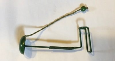
 RAYMOND — This month we have two items we would like folks to check out and see if they know what they are or what they were used for. They were donated by local museum visitors and came from old family homes.
We have had many guesses but no definitive answer. The board item looks homemade and the green metal item looks to be manufactured.
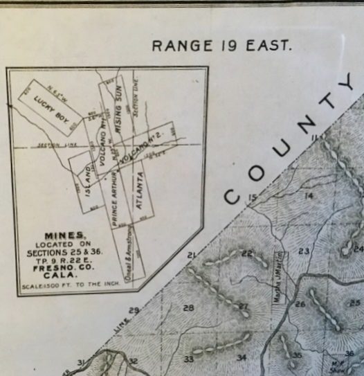 Also, we obtained an 1891 plat map of Fresno County and on the page with an inset of Raymond, was an inset showing several mines.
We would love to know where these mines may have been located. They are not referenced on the Raymond map page. Thank you!
Lynn Northrop at the Raymond Museum
Follow-up on The History Mystery #49
If you are interested in the history of the North Fork area , you are welcome to come to a History Group meeting. We meet at the library on the third Tuesday of each month at 7 p.m.
Thank you for all the comments on the SierraNewsOnline Facebook page. The responses will be researched and catalogued in our files. Some of the comments are listed below:
Lemoore Rangel- When did Bonnie B Road, like so many of the other names Taos’s around North Fork get changed to their current road numbers?
 Alice Bethel – I heard a story when I was little that Bonnie was the mistress of James Bethel (my great great grandfather) and if you do your history research you’ll find out that James Bethel came from Missouri and started a Pony Express station and Wells Fargo stage coach stop; it was called Bethel Station that grew into what is now North Fork. That is a true fact of history, but Bethel Station didn’t start where North Fork is today, it started somewhere on the Bonnie B Ranch. How true her being his mistress is? I don’t know.
Waverly Butcher Dorris – Very interesting. Hope someone out there has more info.
David Scott – Nice to know a little of the history of the name of the road I live off of. Thanks.
Tiffany York – Yes same here!
Criss Wilhite – Bonnie Bladen, I remember that you know a great deal about the Bonnie B Ranch. I remember when you lived there.
Bonnie Bladen – I lived next door to the south. Our understanding is that the ranch was owned by the Bryant family who were absentee owners and that they had a daughter named Bonnie.
Debra Wentz – Ron and Michelle Balthazar once managed and did care taking on the ranch and had their paint horse stud services there. I was told that Dave Bryant had purchased the ranch for his wife (unknown when) and built the custom home for her, however the wife really didn’t like it there, so they rarely came up. I remember one of Ron’s’ “annual duties” was to climb the big tree out front, which sat between both residences and string Christmas lights in the tree every year as per Dave’s wishes,. You could see the lights for quite a distance.
Debra Wentz – Due to the overall size of the Ranch (which sprawled between ‘Bonnie B Road’ and the Southern gate on Rd. 222) is why the road was named as such, just as many of the roads around here were named for/after land owners, ranches , and land developers) i.e; Church Ranch, Walker Ranch, Klettie Pride Way, etc.
Don Grove – Thanks for all the comments, we will check them out. A couple of things we know — The ranch was a cattle ranch named Bar B Bar until 1947. At that time it became a Guest Ranch and was named Bonnie B. Jack Bryant purchased the ranch much later. The Bonnie B Road cut through the ranch for which it was named. The road was Bonnie B when we purchased our home there in 2004. Within a year the Road 224 sign was added and the Bonnie B sign was gone a year or so after that.


Mike Morrow- My folks and I moved into our home on road 224 in 1958 The ranch was across the road from us. At that time it was owned by a family named Arkalian (not sure on spelling) from somewhere in the valley. They didn’t live on the ranch but were there mostly during the summer months. I believe they sold it to mister Bryant in the mid to late seventies.
Comment on the map part of History Mystery #50 – The inset showing the map of mining claims is referenced to T.P. 9 R. 22E. Sections 25 & 36. I looked up Township 9 South, Township 22 East, Sections 25 & 36 on a larger map and the inset is showing mines at Hildreth.
Connie Popelish
Online verification of item of History Mystery #50, can be found at this site, http://www.laurelleaffarm.com/item-pages/1920s-30s-vintage-hat-stand-or-wig-holder-original-jadite-green-paint-Laurel-Leaf-Farm-item-no-nt32818.htm