MOUNTAIN COMMUNITIES — With the strong storms and heavy snow over the past few months, some forest areas and sites are closed due to lingering snowpack, flooding or road damage. Crews are using all available resources to get these areas open and safe for the public to enjoy.
![]() “With the record precipitation we expect to be busy at our national forests, with visitors excited to get outside and enjoy our rivers, lakes and streams this Memorial Day weekend,” said Jim Bacon, director of Public Services for the Pacific Southwest Region. “We want to urge the public to take extra caution this high-water year. Please plan ahead, check access, stay safe, and recreate responsibly.”
“With the record precipitation we expect to be busy at our national forests, with visitors excited to get outside and enjoy our rivers, lakes and streams this Memorial Day weekend,” said Jim Bacon, director of Public Services for the Pacific Southwest Region. “We want to urge the public to take extra caution this high-water year. Please plan ahead, check access, stay safe, and recreate responsibly.”
With closures or delayed openings at popular recreation sites, the USDA Forest Service asks for your patience. They value safety first and offer these tips for everyone to have a positive experience on national forests:
-

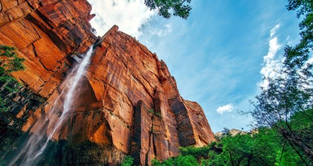
Image by Johannes Andersson.
Before heading to a forest, have a backup plan. Be open to finding a new favorite area to enjoy. With limited locations in some areas and high use in others, consider reserving a campground at www.recreation.gov or call 877-444-6777.
- Know Before You Go. Check in with local Forest Service offices for closures and alerts. Use forest websites and social media for updates on sites and trails for the 18 national forests in California. It is your responsibility to know the area and any restrictions to areas, roads and trails within the national forests.
- Pack essentials. Hikers and campers should always bring essentials including navigation, light sources, first aid supplies, clothes for changing weather, food, water and a smartphone. We recommend hikers send someone not on the hike a detailed plan of where they plan to travel and GPS location when arrive, in case of an emergency.
- Observe all posted signs and warnings. There may not be barriers or signs at each closed location. Remember, GPS is not always reliable with current closures and conditions. And gates should never be opened when closed, even if GPS shows the best route through the area. Citations may still be issued even if no signs exist when a forest order is in place.
- Be aware of your surroundings. Many campgrounds and hiking trails are near lakes and rivers with changing water conditions. Water could be colder and swifter with the record-breaking snowpack now melting. Be aware of winds and avoid areas with dead standing trees. Look up before you choose a trail, park your car, or set up camp. And no matter how tempting, do not park your car illegally and block emergency vehicle access.
Additional Update Information
-
Image by Kevin Andre.
Road to Nelder Grove is closed at gate, but people are still welcome to park at gate (not drive the road up) and hike in until the end of June when the Fuels Reduction Contract goes into effect and the Grove will be closed. Use extreme caution as there are lots of downed trees and debris from the winter storms.
- Willow Creek Trail & Lewis Creek Trail are open and mostly free of obstacles, but water levels are high and rapid.
- The bridge is still out and Corlieu Falls viewing platform on the Lewis Creek Trail.
- Bass Lake: Goat Mountain Trail, Spring Cove Trail and Way of the Mono Trail are open and good hiking trails.
- Chilkoot Campground (up Beasore Road) and Summerdale Campground (off Highway 41 just before Yosemite) should be open by Memorial Day Weekend – check www.recreation.gov.
- USFS is trying to open Grey Mountain and Soquel ASAP.
- USFS keeps finding more damage along forest roads as the snow melts. Please have everyone use caution.
- Beasore Road: May be open to Chilkoot, if Chilkoot campground opens as expected. Otherwise, it is closed.
- Minarets Road (out of North Fork) is closed.
- Sky Ranch Road is open to a little past Nelder Grove turnoff.
- Central Camp Road and Peckinpah Road are also closed.

For additional important information, please check out the following info update:
2023 YOSEMITE SUMMER INFO UPDATE (PDF)
Additional Weather and Planning Resources
- California National Forests | Contact Directory
- Caltrans QuickMap — Current information on road closures
- Weather Watches, Warnings and Advisories | National Weather Service
- Turn Around, Don’t Drown | Ready.gov
- California Office of Emergency Services | Cal OES
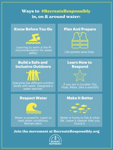
- #RecreateResponsibly | Water Safety
![]() For regional happenings, follow Pacific Southwest Region on Facebook and Twitter. Or search for individual national forests on Twitter.
For regional happenings, follow Pacific Southwest Region on Facebook and Twitter. Or search for individual national forests on Twitter.
Plus, with May as Water Safety Month, follow these water smart reminders:
- Do not enter cold, fast-running water. It can be dangerous for you and first responders.
- Never enter the water to rescue a victim. Throw something that floats and call 9-1-1.
- Do not drive through high waters. Water is often swifter than it appears.