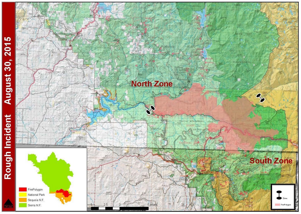
SIERRA NATIONAL FOREST – The Rough Fire, burning near Hume Lake, has now grown to 66,542 acres with 25 percent containment.
There are currently 2,121 personnel assigned to the incident, including 38 crews, 159 engines and 12 helicopters.
Transport winds are expected to push the smoke northeast of active fire today. Significant impacts will continue in areas near the fire and in areas directly below active fire overnight, and burn operations to secure firelines will add to the smoke impact across the Central Sierra.
Unusual warm winter temperatures, below average precipitation, and large scale wildfires could become record setting. The high level of bark beetle associated mortality occurring in Sequoia National Forest is not unique, but wide spread throughout Southern Sierra Nevada.
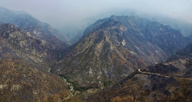
The Sequoia National Forest has been experiencing drought effects for a number of years. Tree mortality directly associated with low precipitation is also a factor, increasing fire danger. Now include the wide glacial valley that is Kings Canyon, which is arguably one of the deepest canyon in North America with massive tall cliffs. There are reportedly parts of Kings Canyon deeper than the Grand Canyon, with a maximum depth of 8,200 feet, which makes for a very volatile and potentially deadly situation.
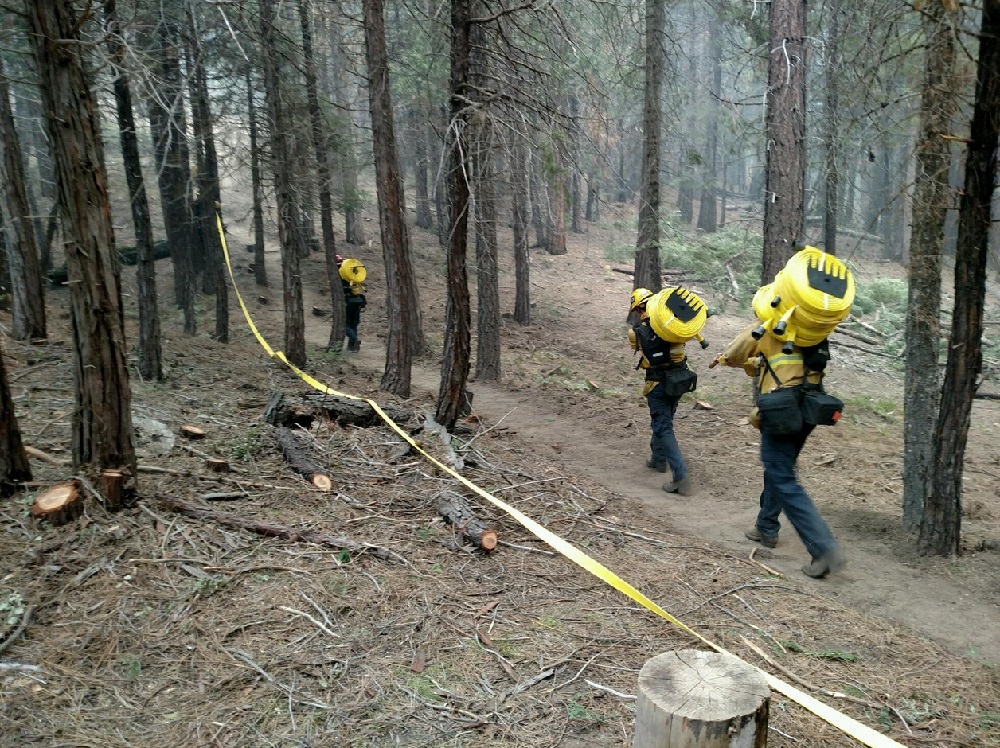 Crews in the northeast section will strengthen the line and continue to protect the community and structures in the Wishon area. In conjunction with the burn operation, crews will begin mopping up along the Crown Valley Trail holding and securing the line. Smoke will continue to be prevalent and air quality will be impacted.
Firing operations are planned in the north and east sections of the fire. If conditions are favorable, firing operations will occur in the interior to fill in unburned areas to prevent large fire runs to the north and east.
The Balch Camp area remains in mop and patrol. The evacuation warning in Wishon will remain in effect while burning operations continue to the south. Visitors, community members and PG&E employees are being kept informed of the fire’s status through daily meetings at 5 p.m. at Wishon Village.
Fire in the Converse Basin remains active, with uphill runs toward Hoist Ridge. Lines have been established and reinforced with retardant drops along the ridge.
Jackpots of beetle-killed trees are exhibiting extreme fire behavior, causing spotting ahead of the fire.
Backfire operations started last night toward Buck Rock to remove fuel ahead of the fire and stop the southerly progress along the eastern front. Lines are being completed along the forest road from Horse Camp toward the Deer Meadow Trail Head as a contingency.
 Fire in the northeast is moving along the Grizzly Creek Drainage. Southwest winds will come into alignment with the drainage causing long runs into Little Tehiple Valley in the Monarch Wilderness.
Structure defense preparation will begin around the Cedar Grove area today as a precaution.
The fire perimeter is being mapped using infrared-equipped aircraft. Infrared technology has the advantage of being able to “see” the fireline through smoke and darkness. The aircraft fly the fire at night when temperature contrasts make detecting the fireline easier and report the data back to the GIS (geographic information system) unit which overlays the data to maps. Fire commanders on the ground then use the maps to make decisions about tactics and effective placement of personnel and equipment.
Due to current fire conditions, fire closures and/or restrictions on public lands are expected for the 2015 hunting season. If you plan to hunt on U. S. Forest Service lands this year, it is important to monitor the individual forests’ websites for updates on forest closures and contact the California Department of Fish and Wildlife.
A Fire Behavior Assessment Team (FBAT) is assigned to the Rough Fire. They are a unique fire module that measures pre-fire fuels/vegetation, active fire behavior (with sensors in the fire), and post-fire fuels/vegetation conditions during wildfires and prescribed fires.
The suppression strategy for the Rough Fire will utilize a combination of direct, indirect and point protection. A key element of the plan is flexibility and the ability to apply the right resource, to the right task, at the right time, for the right duration. It is understood fireline will be constructed only where it is feasible and safe to do so. It is the responsibility of the Incident Commander and their staff to work with the Agency Administrators to ensure the plan is regularly reviewed and updated.
California is in the midst of fire season. Ensure that you follow local fire restrictions, remain mindful of fire prevention, and maintain required defensible space around your home. In addition, have a plan following the Ready, Set, Go! program to evacuate should the need arise this season. To find out more about what you can do to prevent human caused, unwanted wildfires, please go to www.preventwildfireca.org
When disaster strikes, the same rules that apply to people apply to pets: Preparation makes all the difference, and if it’s not safe for you, it’s not safe for them. Click here to learn about an evacuation plan for your pet.
The Rough Fire began July 31. On Tuesday, Aug. 18, the Rough Fire spotted across the South Fork of the Kings River and crossed highway 180 in the area of Horseshoe Bend and became established in the Lockwood Creek Drainage. As a result of the fire crossing the river, the pre-planned evacuation of the Hume Lake area was implemented. Over 2,500 campers, hikers, employees, and residents were notified and safely evacuated from Hume Lake Christian Camp, private cabins, campgrounds, and the surrounding area in just over 2 ½ hours.
As the fire spread existing closure orders were expanded to include almost the entire Hume Lake Ranger District. The current closure is defined in Forest Order 15-19, which closes these areas for public safety:
• most of the Hume Lake Ranger District from Delilah Rd. on the west to Jennie Lakes and Monarch Wildernesses to the east; and from Hwy 180 in the south to the Forest boundary to the north. (see included map); Sequoia & Kings Canyon National Parks issued a closure of the Cedar Grove area and the Grant Grove area.
• Sierra National Forest issued a closure order for the Rough Fire Area.
• Black Rock Campground and Forest Road 11S12 (also called Black Rock Road) is closed between Balch Camp and McKinley Road.
• Sequoia National Forest issued a closure order for the Hume Lake Ranger District, Jenny Lakes Wilderness and Monarch Wilderness, including Forest Road 12S01, 12S01E, and 12S19 in the Sequoia Highlands area.
• The Hume Lake recreation area is closed, as is Hwy 180 beyond the junction of Hwy 198 (Generals Highway).