Storms were scheduled to come in later in the day and we were thinking of a hike close to home, so we headed up the Lewis Creek Trail, traveling back in time as we walked along what was once the Sugar Pine Madera-Sugar Pine Lumber Company flume.
Where: Sierra National Forest
Distance: 3.81 Miles
Difficulty: Easy to Moderate
Elevation Range: 3,325′ – 3,906′
Date: December 7, 2016
Maps: Ahwahnee Topographic Quad Map
Dog Hike? Yes, depending on your dog
 We drove north on Highway 41, turned right on Cedar Valley Road and headed about a mile up the road to the trailhead sign on the left where we parked. There are several different ways that you can hike this trail though. Other access points include the turnout on Highway 41 just above the 4,000 elevation sign and off of Sugar Pine Dr.
The trail started heading up along side Lewis Creek, which is named for Jonathan Lewis who homesteaded in Cedar Valley. It follows along the route of the old Madera-Sugar Pine Lumber Company flume that extended from the Sugar Pine Lumber Mill in Sugar Pine to the north of the trail, southwest to the San Joaquin Valley town of Madera. The sawed boards were floated down the “V” shaped flume to the railroad line in Madera. Wooden trestles as high as 60 feet above the ground helped span the draws along its route. A catwalk that was only ten inches wide along the flume helped the “herder” to keep the lumber moving and the lumber was held together with large iron staple-like clamps. Over 1 billion board feet of lumber passed down the 54 mile flume that operated from 1900 to 1931.
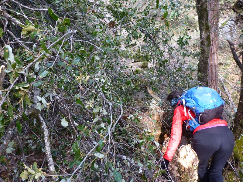
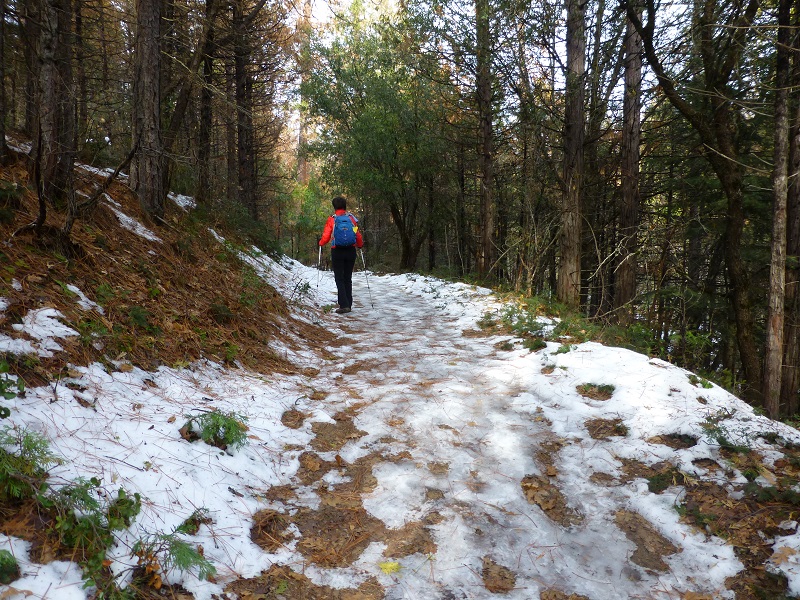
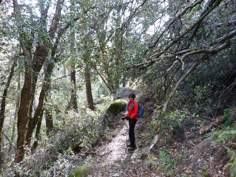
The trail was cut into the side of the hill that got steeper as we climbed. And wouldn’t you know it, we came across a tree that had fallen across the trail in that steeper area. We climbed through, over and around its branches.
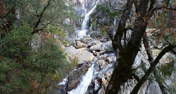
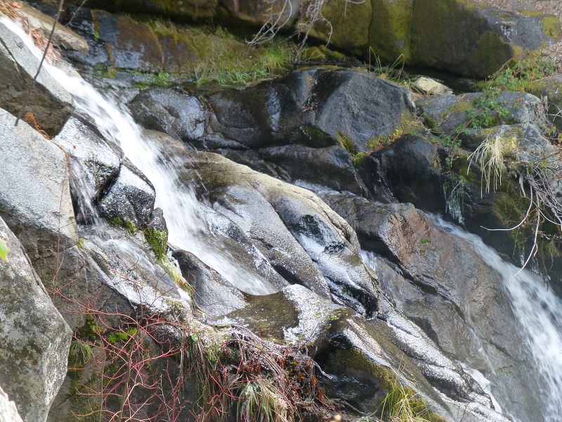
After a little over a mile, we reached the lower portion of Corlieu Falls.
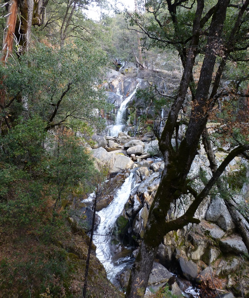
Corlieu Falls is named after Charles Clifford Corlieu, born 1861 at Boon, Franklin County, Missouri to John Harvey Corlew and Eliza Anna Sexton. Sometime after Eliza and their newborn daughter died in 1865, John Harvey Corlew and his sons headed to California. He remarried to Anna MacDonald 1878 in Fresno County and is enumerated on the 1880 census, a farmer with his wife, sons Charles and William living in Auberry Valley.
In 1884, Charles Clifford married C. Dora McDonald in Fresno County.
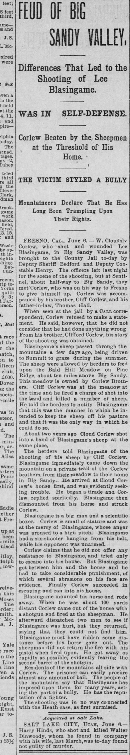
San Francisco Chronicle June 7, 1896
Fresno Republican June 19, 1896
There was a bit of trouble with the Corlew and Blasingame families near Big Sandy on property owned by Charles Clifford and his brother William Cloudsley in late May of 1896. Lee Blasingame’s sheep passed through the meadow owned by the Corlews. Cliff fired a shot into the herd of sheep and killed several of them. He told the herders to let Blasingame know what had happend. But this wasn’t the first time something like this had happened. A couple of years before this his brother had fired into a herd of sheep grazing in the same place. After the herders told Blasingame, he quickly came down to Cloud’s place and was not happy. Blasingame had a six-shooter hanging from his belt and Cloud was unarmed. According to newspaper articles, Cloud took “considerable punishment” from Blasingame resulting in abrasions to his face but escaped. As Blasingame was riding off, Corlew took a shot at him with his shotgun, wounding him. Blasingame did not fire back but got away as fast as he could. If you click on the newspaper clippings, you can read an article about the event, along with a letter from Cliff explaining the situation and how this didn’t have anything to do with the “Heath case”. Guess there were other wild times with the Corlews.
On January 8, 1897, there is a colorful mention in the Fresno Weekly Republican about C. C. Corlew receiving the assistant janitor job at the courthouse saying that “he was an expert at filling gentlemen’s hides with buckshot” according to Lee Blasingame. In that same newspaper on March 5, 1897, there is an short mention that C.C. Corlew had moved his family from Big Sandy to Fresno. The August 13, 1897 newspaper reports that C.C. Corlew had successfully petitioned for a raise from $55 to $60 per month.
On the 1900 census, John Harvey and Anna own their land and are living in Auberry. Charles Clifford, occupation listed as farmer, wife Dora and their 4 children are living next door. John Harvey died 1901 and Anna died 1909 in Fresno County.
Charles Clifford’s last name is spelled several different ways on the records that I located but the most consistent spelling is Corlew. Corlieu and Carlew are a couple of variations that I have found so it isn’t surprising that I was unable to locate Charles Clifford on the 1910 census. His last name might be terribly misspelled or perhaps the census taker missed him along the way. On the 1920 census, Charles Clifford is living in the Enterprise Precinct, Madera County with wife Evaline M. He owns his home and his occupation is listed as Gold Miner. His first wife Dora is living with two of her children in Oakland and says she is a widow.
I wonder what prompted Mr. Corlieu to leave the Auberry area for the seclusion of Corlieu Falls.There were certainly some difficult times that were going on in the Auberry area.It is said that on a trip to Sugar Pine to visit one of his daughters, Corlieu liked the mineral warm springs on the Lewis Creek Trail. He filed mineral claims for nearby land and built a cabin overlooking the falls that now bear his name. Corlieu, who adopted the nickname “Cliff Man”, drilled out a bathtub in a boulder and piped in spring water to create a natural hot tub. Many people came to visit this hot tub and it is said that President Theodore Roosevelt bathed in it on a visit.
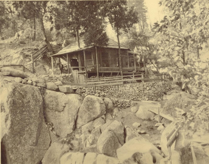
Clifford Corlieu’s Cabin above Corlieu Falls (Photo courtesy Dr. Well’s Family Collection and Brenda Negley)
Mr. Corlieu was also an author and wrote a 140-page book, “Sierra Sanctum: Written Reveries of a Cliff Man” that was published in 1926. This book has been out of print for a very long time but you can also read some of Mr. Corlieu’s versus in Brenda Negley’s new book “Nelder Grove of Giant Sequoias: A Grandaughter’s Stories.” I have a copy of this book and thought I would share a little from the section he called Cliff Man:
The forest groves
He dearly loves,
Spread out o’er steep and canyon;
The bush and herb With bloom superb;
All natures his companion.
Charles Clifford Corlieu died in July 19, 1929 in Fresno County according to the California Death Index.
In the 1930s, a resort was built at Corlieu Falls under a special use permit from the Forest Service. The resort was removed in the 1940s. According to the Sierra National Forest, Mr. Corlieu’s son-in-law, Samuel L. Mobley, staked mining claims in the area, but he sold some parcels as lots for cabins, which he was not entitled to do. Mobley also opened a restaurant and museum on a trailhead near Corlieu’s former resort. Mobley vacated the land in the 1960s, the restaurant and museum buildings were removed and the area was allowed to return to its natural condition.
We followed the trail to the top of the falls where we could look down on them. We could see ice clinging to the rocks.
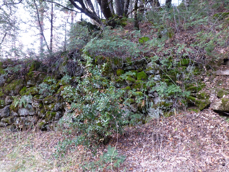
At the top of the falls, there are many old rock foundations. I am sure that some of these are from the cabin that Corlieu built in this area overlooking the falls and that is how he came to call himself the “Cliff Man.”
The trail had more snow and ice on it at this point, so we had to watch our footing.
Charles Clifford Corlieu was buried along this portion of the trail and there used to be a wooden marker on his grave. I had some pretty good directions to his gravesite, along with an old picture, but was unable to locate its site. I think I was in the area but just couldn’t find any sign of the grave. I had heard that the marker had been gone for years but I still had hope of finding something.
We continued up to where the old bridge crossed Lewis Creek, which was taken down due to safety concerns in 2015. It was actually an old tree that had fallen across the creek but had been made into a bridge. Over the years it had rotted and the integrity of the bridge was so bad it was determined to be structurally unsound. Steven Beri, National Resources Specialist and Trail Supervisor for the Sierra National Forest, shared with SNO in a 2015 interview that large boulders had been strategically aligned for a rather natural crossing of Lewis Creek. He also said the Forest Service wants to do something more permanent, but at this time they don’t have a specific timetable or proposal, and have forest priorities that may keep this on the back burner for a while.
Well, those boulders were not so strategically aligned on our hike. Those that were there were covered in ice and snow. But there was a log jam a little upstream but it was also covered in ice and snow. We talked about wading across but we really weren’t wild about doing any of these. We could see footprints on the other side so some braver souls that us made one of these crossings. We spent a little time trying to find a easier way across but decided to head back down the trail.
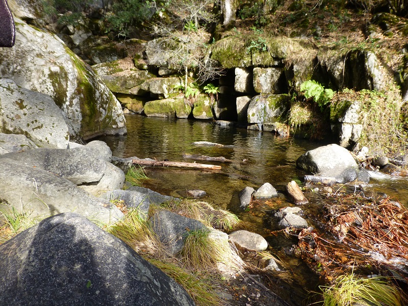
A pool of water below the falls caught our eye and we wandered down to the creek to check it out.
Heading down the trail, we discovered that the fallen tree had been cleared by the USFS crew that we met along the way. Thank you!!
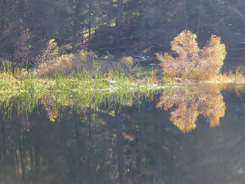
We continued our walk up to the Cedar Valley Fire Station where we ate our lunch at the picnic tables and took in the reflections in the pond. Not what we planned for lunch but it was a very nice lunch spot.
Dog Hike? Maybe
I didn’t bring Sally on this hike, but she would have been welcome on it. Here are the Sierra National Forest rules for pets from their website:
Domestic pets are allowed in wilderness areas. You are responsible for their actions as well as their welfare. Pets should either be leashed or under direct voice control. When camping in areas with other visitors, pets should be kept on a leash. Wilderness visitor’s who plan to travel into an adjacent National Park should be aware that National Parks do not permit pets.
When in campgrounds, public beaches or on trails local ordinances require pets to be leashed. As a consideration to others, please refrain from taking pets to beach areas to prevent contamination. Domestic pets are allowed in wilderness areas. You are responsible for their actions as well as their welfare. Pets should either be leashed or under direct voice control. When camping in areas with other visitors, pets should be kept on a leash. Wilderness visitor’s who plan to travel into an adjacent National Park should be aware that National Parks do not permit pets.
- Clean up after your pet. It will only take a few minutes and there is no single action that will more favorably impress your fellow campers.
Map and Profile:
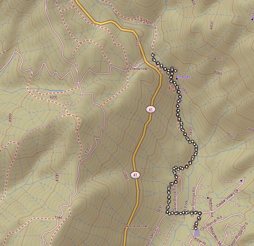
Lewis Creek Trail to Corlieu Falls Topographic Map
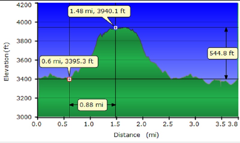
Lewis Creek Trail to Corlieu Falls Topographic Profile
Sources:
Lewis Creek, Charles Corlieu Fresno Bee
San Francisco Republican, June 7, 1896
Fresno Republican, June 19, 1896
Mitchell, Roger & Loris, Exploring the Sierra Vista National Scenic Byway: A Definitive Guide to the Hidden Heart of the Central Sierra, Track and Trail Publications, 2006
Negley, Brenda L., Nelder Grove of Giant Sequoia: A Grandaughter’s Stories, Otter Bay Books, 2016

