Photo credit Kari Greer
MARIPOSA COUNTY – A heavy inversion layer kept fire activity at a fairly moderate level for crews on the Ferguson Fire today, despite the high temperatures.
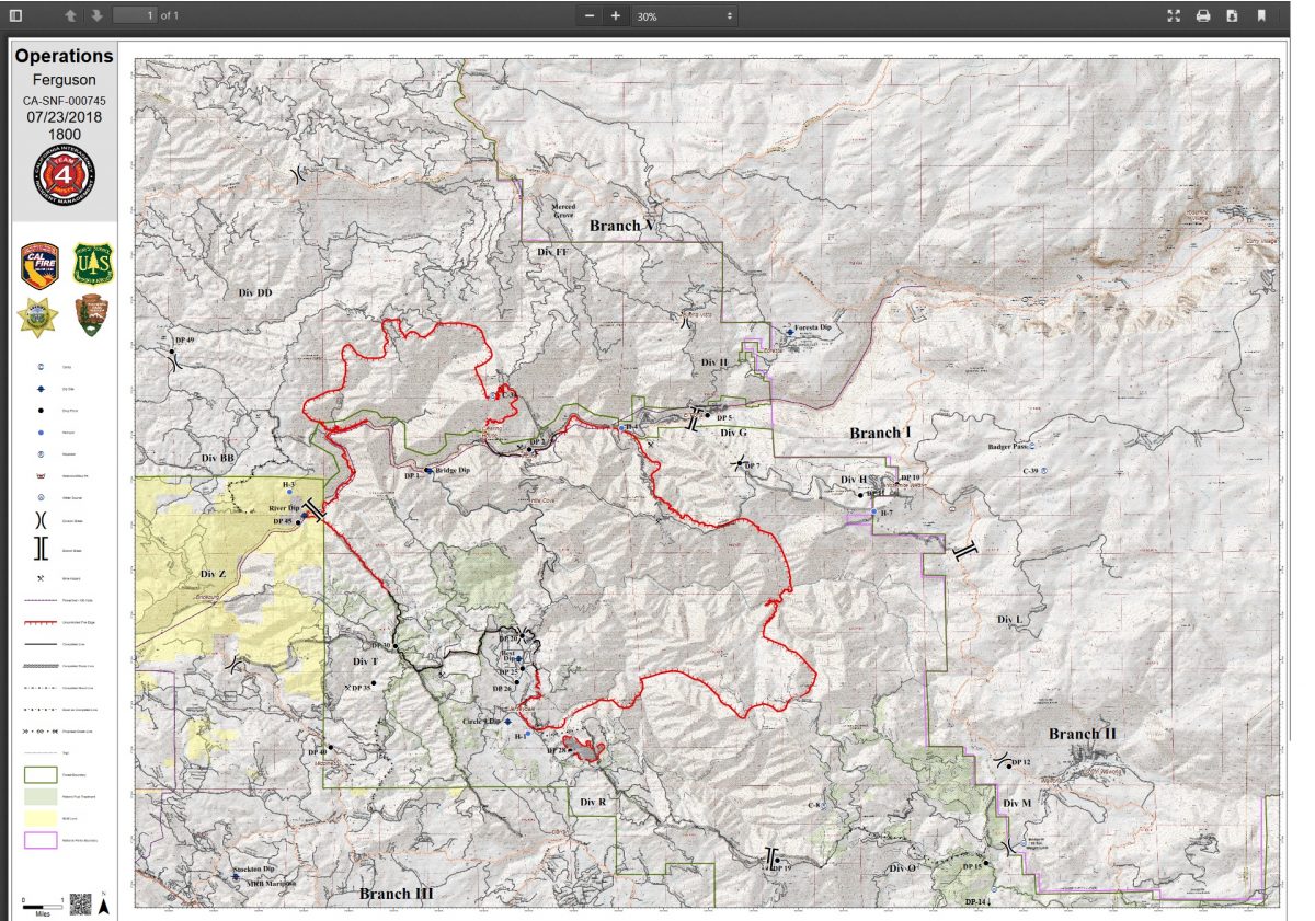
The fire is now estimated at 36,102 acres with 16 percent containment.
One nonresidential structure has been destroyed, say fire officials, and nearly 3,500 more are threatened. No new evacuations were ordered today.
There are currently 3,311 personnel assigned to the incident including 194 engines, 91 crews, 45 water tenders, 52 dozers, 16 helicopters, and fixed-wing tankers as conditions allow.
There was a slop-over on southern fireline east of the Jerseydale Road overnight, and another this morning that grew to about 10 acres. Both have been contained.
North of the Merced River on the northwest corner, firefighters initially worked to put in direct line, but the fire was too active and they had to back off and utilize the road systems to establish contingency line.
Starting at the river, the line runs north and west, up through Jenkins Hill to Pilot Ridge. That’s where they come close to the county line and the burn scar of the 2013 Rim Fire.
The roads in that area have been prepped in the past, and fire officials say there are currently crews and dozers working that contingency line, and opening it up again should be fairly quick work.

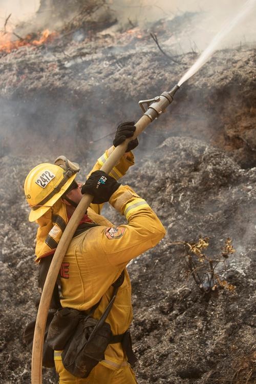
Bear Valley Shot Shots on Ferguson Fire – photo credit Kari Greer
From there, they are using the Old Yosemite/ Coulterville Road down to Buena Vista, where crews and dozers are tying in to Eagle Peak. There is handline completed from Eagle Peak to El Portal. They have also assessed the fuel load in that area in case firing operations are deemed to be the best plan.
Once those contingency lines are complete and that “big box” has been created, firefighters will work on more direct attack where terrain and conditions allows.
The immature vegetation growth in the footprint of the 2011 Motor Fire has helped to slow the fire’s progression northeast on the Stanislaus National Forest.
Crews remain in the El Portal and Yosemite West areas and are ready to conduct firing operations just above Zip Creek when conditions are conducive for best results. Resources are at the ready in El Portal and Yosemite West for structure protection.
 Line is being constructed from El Portal over to Highway 41 inside Yosemite, south of Yosemite West. With the terrain on the eastern perimeter too steep and dangerous to insert firefighters, they may let the fire naturally progress eastward and have better ground to take a stand closer to Highway 41. They also have the more recent burn scars of the Empire Fire and the South Fork Fire to utilize if necessary.
West of the Wawona Campground, handline is complete down to the old Chowchilla Mountain Road, and dozer line below Signal Lookout (Devils Peak) across to Footman Ridge should be completed tonight. Fallers will work the day shift tomorrow to remove trees and finish cleaning up the line.
The line headed northwest from Signal up to Jerseydale and Mariposa Pines is already prepped. Crews will continue to fire inside those containment lines.
Mop-up and strengthening of the fireline continues around Mariposa Pines and Jerseydale so that those communities can be repopulated as soon as possible.
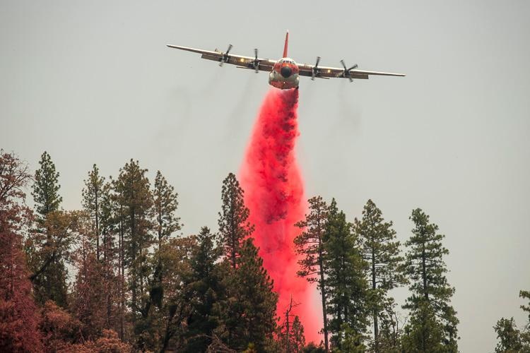
C-130 over Ferguson Fire – photo credit Kari Greer
Along Sweetwater Ridge on the western flank, crews have finished the firing operations and the line is holding well.
A pair of DC-10s and numerous helicopters were at work over the fire as smoke conditions allowed.
There have been six firefighter injuries reported. There has been one fatality on the fire.
A Ferguson Fire community meeting is scheduled for Tuesday, July 24, at 11 a.m. at the Yosemite Valley Auditorium, 9035 Village Drive in Yosemite National Park. Representatives from the Unified Command of Cal Fire, the U.S. Forest Service and the Mariposa County Sheriff’s Office will present an overview of the current situation and actions underway to contain it. Parking is available along Village Drive or in the Yosemite Village Parking Area.
As of July 21, there are fire restrictions in place on the Sierra National Forest. Please read and be informed before you use any type of fire in the forest.
The Glacier Point Road inside Yosemite National Park has been closed to accommodate firefighting resources and activities at a small base camp located at the Yosemite Ski and Snowboard Area (formerly Badger Pass) and Bridalveil Creek Campground (which is also closed).
Caltrans working on Highway 140 on Ferguson Fire – photo USFS
Though the west entrance (El Portal) to Yosemite National Park on Highway 140 is closed, the park remains open. For information on Yosemite National Park, go to nps.gov/yose or call 209-372-0200.
The Incident Command Post for the Ferguson Fire is located at the Ahwahnee Hills Regional Park. Please be aware of heavy fire equipment moving through the area.
The fire is under Unified Command with Cal Fire, U.S. Forest Service, Yosemite National Park and the Mariposa County Sheriff’s Office. Management of the fire transitioned to a Type 1 Management Team – California Team 4 on Thursday.
The Ferguson Fire started on Friday, July 13, at 8:30 p.m. The cause remains under investigation.
Smoke from the Ferguson Fire is impacting the Mariposa County Air Pollution Control District and across the region. For information specific to Mariposa County visit http://www.mariposacounty.org/index.aspx?NID=1434. For additional information on air quality you can visit the AirNow website or the air fire smoke page.
Residents can check the San Joaquin Valley Air Pollution Control District’s wildfire page at www.valleyair.org/wildfires for information about any current wildfires and whether they are impacting the Valley. The District’s Real-time Air Advisory Network (RAAN) provides localized air quality data from an extensive air-monitoring network which allows Valley residents to track PM at any Valley address by visiting myraan.com.
There was a celebration of the life of Cal Fire Heavy Fire Equipment Operator Braden Varney today in Modesto. Varney lost his life on the first shift of the Ferguson Fire when his dozer rolled in steep terrain. Though firefighters are still committed to the job at hand, they are in mourning for the loss of a brother and a friend.
Evacuations
Mandatory evacuations are in place for:
- Savage Trading Post
- Redbud Lodge
- Cedar Lodge
- Indian Flat Campground
- Mariposa Pines
- Sweetwater Ridge
- Ferguson Ridge
- Jerseydale including all residences on Jerseydale Road, Hites Cove Road and all side roads from Triangle Road to the end of Hites Cove Road
- Incline Road from Clearing House to the Foresta Bridge in El Portal
- The BLM campgrounds in Briceburg are closed until further notice
- El Portal Trailer Park
- Old El Portal
- Rancheria Flat- Government Housing
- Foresta
- Yosemite View Lodge
- Yosemite West
- Anderson Valley
- Old Yosemite Road
Advisories have been issued for the following locations:
- Lushmeadows Community
- Ponderosa Basin Community
- Triangle Road from Jerseydale Road to Highway 49 South including all side roads
- Darrah Road from Triangle to Sherrod Road
- East side of Highway 49S from Darrah Road to Harris Cutoff Road – This includes Boyer Road, Woodland Area, Wass Road and Tip Top Road
These areas are NOT under a mandatory evacuation order. This is an advisement only of a potential evacuation order should conditions change.
Should these areas come under a mandatory evacuation order you will be notified via the Sheriff’s Office Emergency Alert System by text, email and a voice call, the Mariposa County Sheriff’s Office Facebook page, and door-to-door communication by Sheriff’s Office staff. At that time you will be notified of the best routes of travel to safely evacuate your residence.
A Red Cross Evacuation Center has been established at the New Life Christian Church located at 5089 Cole Road in Mariposa. If you have been evacuated due to the Ferguson Fire, the Sheriff’s Office asks that you please check in with the Red Cross Shelter even if you do not plan to stay there.
If you are in a Mandatory Evacuation or Advisory Area and may require assistance with evacuation transportation due to special needs or medical issues, please contact Human Services toll free at 1-833-423-0816 as soon as possible.
Planning ahead will help with a safe and timely evacuation.
Animal Evacuation Centers
Small Animal Shelter is at SPCA of Mariposa County, 5599 Highway 49 in Mariposa.
Large Animal Shelter is at the Mariposa County Fairgrounds, 5007 Fairgrounds Road in Mariposa.
Road Closures
Also closed are Jerseydale Road, Hites Cove Road and all side roads from Triangle Road to the end of Hites Cove Road; River Road from Briceburg to the gate at Railroad Flat and all campground areas are closed; Hites Cove Road from Bear Clover Road to the Merced River, Anderson Valley Road and Old Yosemite Road.
Cooperating Agencies include the Mariposa County Sheriff’s Office, Madera County Sheriff’s Office, CAL OES, California Highway Patrol, Caltrans, California Department of Corrections and Rehabilitation, American Red Cross, National Weather Service, California Conservation Corps, BLM and additional agencies throughout the state.