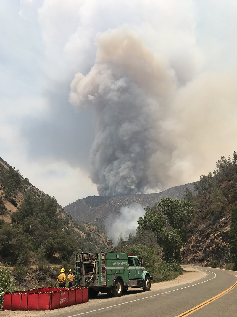
Cleveland National Forest engine on Ferguson Fire – photo Jacob Welsh Ferguson Fire PIO
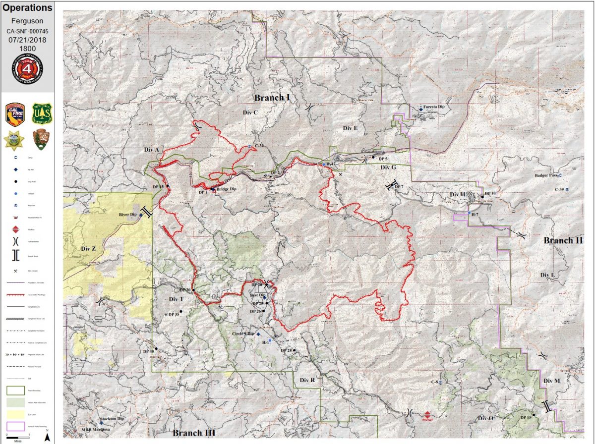
MARIPOSA COUNTY – The Ferguson Fire grew more than 1,900 acres today after the inversion lifted, with most of the activity on the north flank of the fire.
It is now estimated at at 29,045 acres with 6 percent containment.
Most of the increased acreage was north of Highway 140 near Ned’s Gulch where the fire spotted over yesterday.
Both air and ground resources engaged the fire early but were unable to make headway in the steep, rugged terrain.
Fire officials expect this northern portion of the fire to remain active throughout the night as heavy dead and down vegetation continues to burn.
Firefighters will continue to scout the area for places to construct handline on the edge of the fire, and look for options to cut indirect line where the terrain is too dangerous.
Crews continue their work on the line running from El Portal east to Wawona Road. Much of the line is complete and hose lays are in place in preparation for tactical firing operations that will remove fuels as the fire pushes east.
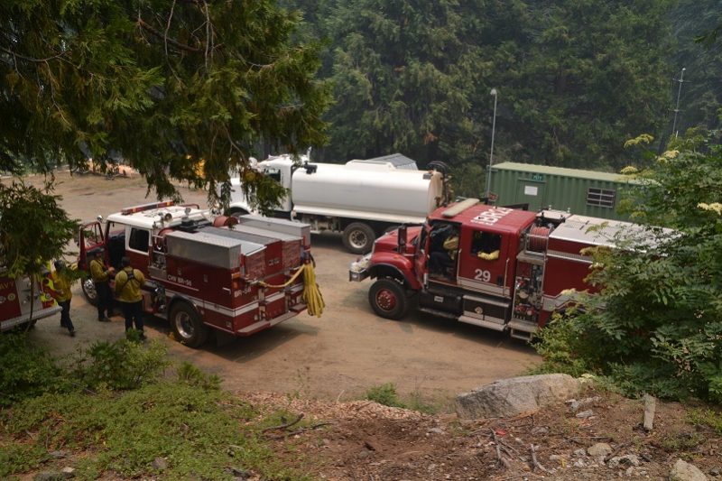
Engines staging at Yosemite West – photo Gina Clugston
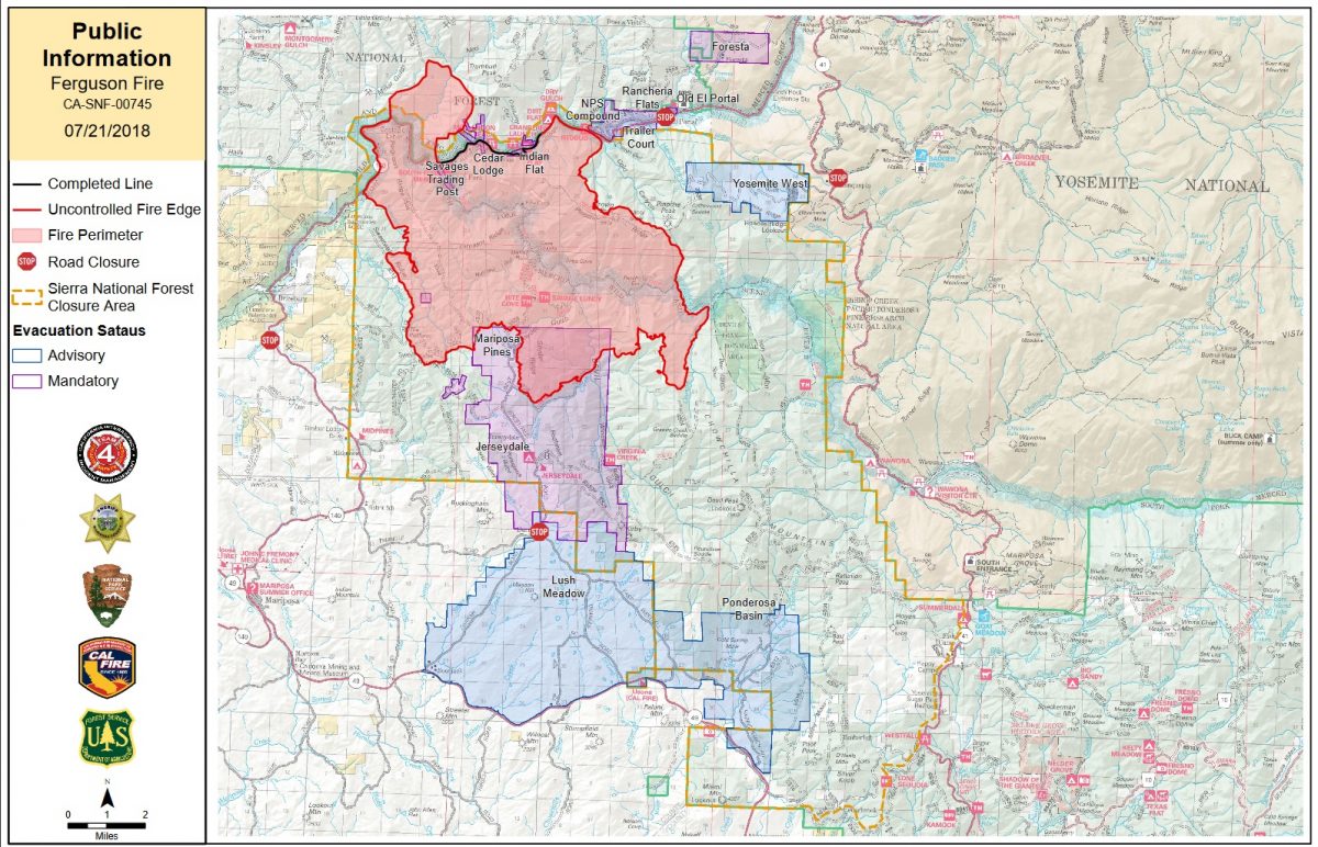
At 9:43 a.m., a mandatory evacuation of Yosemite West was ordered. Smoke was very heavy in that part of the park this morning, as cars along the road from the south entrance to Chinquapin Junction drove with their headlights on.
By 1 p.m., most everyone had left the Yosemite West area. Just one home appeared to still be occupied, and that family was hurrying to load belongings into cars and pickups.
Engines were staged in parking areas, dozer transports sat empty at the bottom of Henness Ridge Road as their operators cut and improved line farther down the mountain, and hose was stacked and ready to be deployed for structure protection.
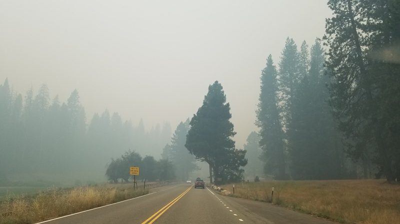 There was no visibility at all from Yosemite West this morning. The smoke in Wawona was also very dense, but by about 1:30 p.m. had cleared off for the most part.
At 1:30 p.m., Anderson Valley – north of the new spot fire on the Stanislaus National Forest – was placed under a mandatory evacuation.
On the west side of the fire the inversion cleared enough in the morning to get helicopters into the air and working, though conditions changed throughout the day. Fixed-wing were delayed until mid-afternoon.
Along the horseshoe on the southwest perimeter that surrounds the communities of Jerseydale and Mariposa Pines, firefighters continue to hold those lines, mopping up some of the remaining hot spots and smouldering embers. That work will continue.
On the southeast flank near Skelton Creek, the fire was very active today. Firefighters are scouting for options to cut indirect line.
There are currently 2,832 personnel assigned to the incident including 204 engines, 70 crews, 41 dozers, 38 water tenders, 17 helicopters, and fixed-wing aircraft as conditions allow.
There are 216 structures threatened by the Ferguson Fire, but none have been damaged or destroyed.
There have been four firefighter injuries reported. There has been one fatality on the fire.
There will be a celebration of the life of Cal Fire Heavy Fire Equipment Operator Braden Varney on Monday, July 23, in Modesto. On Sunday, July 22, from 2 to 6 p.m., there will be a visitation, open to the public, at Franklin & Downs Funeral Home, 1050 McHenry Ave in Modesto.
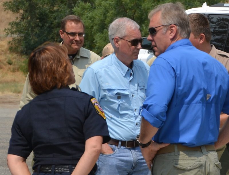 Interior Secretary Ryan Zinke and Congressman Tom McClintock visited the Incident Command Post today, and were briefed on the situation by members of the incident management team (California Team 4), officials from Cal Fire, Yosemite National Park and the Sierra National Forest, and by Mariposa County Sheriff Doug Binnewies and Madera County Sheriff Jay Varney.
McClintock expressed his admiration for those who “put themselves between the fire and our communities.”
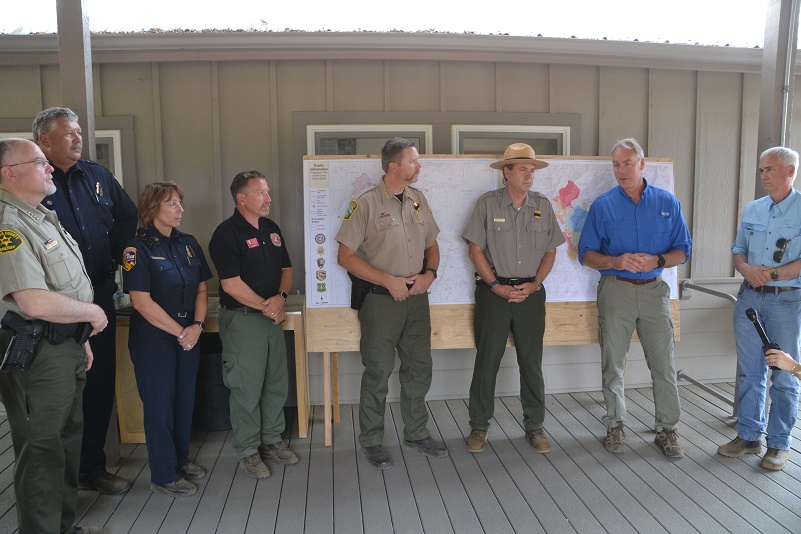
Madera Sheriff Jay Varney, Cal Fire IC Billy See, MMU Chief Nancy Koerperich, Cal. Team 4 IC Jay Kurth, Mariposa Sheriff Doug Binnewies, Yosemite Superintendent Mike Reynolds, Interior Secretary Ryan Zinke, Congressman Tom McClintock
“All along those firelines are people with families,” he said, “and every time I visit one of these command centers in this region that’s been so ravaged by catastrophic wildfire, I’m just filled with a sense of awe at the courage and devotion of those who fight these fires, and we recognize the sacrifices being made on our behalf.”
Interior Secretary Zinke talked about his commitment to putting all necessary resources in place to fight this fire, and to going “back to the model of actively managing our forests.
“Everyone agrees that active fire management starts by removing the dead timber and by vegetation management,” said Zinke. “I’ve signed a secretarial order to do just that. We’re all stakeholders and we need to make sure we return to healthy forests.”
The Incident Command Post for the Ferguson Fire is now at the Ahwahnee Hills Regional Park. Please be aware of heavy fire equipment moving through the area.
The fire is under Unified Command with Cal Fire, U.S. Forest Service, Yosemite National Park and the Mariposa County Sheriff’s Office. Management of the fire transitioned to a Type 1 Management Team – California Team 4 on Thursday.
The Glacier Point Road inside Yosemite National Park has been closed to accommodate firefighting resources and activities at a small base camp located at the Yosemite Ski and Snowboard Area (formerly Badger Pass) and Bridalveil Creek Campground (which is also closed).
Though the west entrance (El Portal) to Yosemite National Park on Highway 140 is closed, the park remains open. For information on Yosemite National Park, go to nps.gov/yose or call 209-372-0200.
The Ferguson Fire started on Friday, July 13, at 8:30 p.m. The cause remains under investigation.
Smoke from the Ferguson Fire is impacting the Mariposa County Air Pollution Control District and across the region. For information specific to Mariposa County visit http://www.mariposacounty.org/index.aspx?NID=1434. For additional information on air quality you can visit the AirNow website or the air fire smoke page.
Residents can check the San Joaquin Valley Air Pollution Control District’s wildfire page at www.valleyair.org/wildfires for information about any current wildfires and whether they are impacting the Valley. The District’s Real-time Air Advisory Network (RAAN) provides localized air quality data from an extensive air-monitoring network which allows Valley residents to track PM at any Valley address by visiting myraan.com.
Evacuations
New today: At 9:42 a.m. the Mariposa County Sheriff’s Office issued a mandatory evacuation order for Yosemite West. At 1:30 p.m. Anderson Valley, north of the large spot fire on the Stanislaus National Forest, was also ordered to evacuate.
Mandatory evacuations are in place for:
- Savage Trading Post
- Redbud Lodge
- Cedar Lodge
- Indian Flat Campground
- Mariposa Pines
- Sweetwater Ridge
- Ferguson Ridge
- Jerseydale including all residences on Jerseydale Road, Hites Cove Road and all side roads from Triangle Road to the end of Hites Cove Road
- Incline Road from Clearing House to the Foresta Bridge in El Portal
- The BLM campgrounds in Briceburg are closed until further notice
- El Portal Trailer Park
- Old El Portal
- Rancheria Flat- Government Housing
- Foresta
- Yosemite View Lodge
- Yosemite West
- Anderson Valley
Advisories have been issued for the following locations:
- Lushmeadows Community
- Ponderosa Basin Community
- Triangle Road from Jerseydale Road to Highway 49 South including all side roads
- Darrah Road from Triangle to Sherrod Road
- East side of Highway 49S from Darrah Road to Harris Cutoff Road – This includes Boyer Road, Woodland Area, Wass Road and Tip Top Road
These areas are NOT under a mandatory evacuation order. This is an advisement only of a potential evacuation order should conditions change.
Should these areas come under a mandatory evacuation order you will be notified via the Sheriff’s Office Emergency Alert System by text, email and a voice call, the Mariposa County Sheriff’s Office Facebook page, and door-to-door communication by Sheriff’s Office staff. At that time you will be notified of the best routes of travel to safely evacuate your residence.
The following Red Cross locations are open to assist anyone affected by wildfires:
A Red Cross Evacuation Center has been established at the New Life Christian Church located at 5089 Cole Road in Mariposa. If you have been evacuated due to the Ferguson Fire, the Sheriff’s Office asks that you please check in with the Red Cross Shelter even if you do not plan to stay there.
A second Evacuation Center has been opened to further accommodate those affected by the Ferguson Fire, located at Yosemite Valley Elementary School, 9009 Lost Arrow, in Yosemite Valley.
If you are in a Mandatory Evacuation or Advisory Area and may require assistance with evacuation transportation due to special needs or medical issues, please contact Human Services toll free at 1-833-423-0816 as soon as possible.
Planning ahead will help with a safe and timely evacuation.
Animal Evacuation Centers
Small Animal Shelter is at SPCA of Mariposa County, 5599 Highway 49 in Mariposa.
Large Animal Shelter is at the Mariposa County Fairgrounds, 5007 Fairgrounds Road in Mariposa.
Road Closures
Also closed are Jerseydale Road, Hites Cove Road and all side roads from Triangle Road to the end of Hites Cove Road; River Road from Briceburg to the gate at Railroad Flat and all campground areas are closed; Hites Cove Road from Bear Clover Road to the Merced River.
Cooperating Agencies include the Mariposa County Sheriff’s Office, CAL OES, California Highway Patrol, Caltrans, California Department of Corrections and Rehabilitation, American Red Cross, National Weather Service, California Conservation Corps, BLM and additional agencies throughout the state.