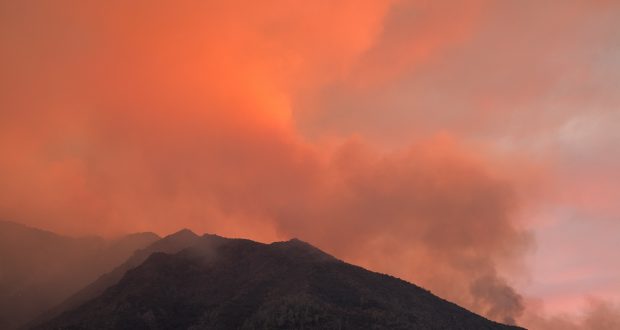
Ferguson Fire sunset from above Rancheria mines – photo by Dustin Garrison
MARIPOSA COUNTY – Mountain area residents woke to another day of dense smoke as the Ferguson Fire continues to burn south of Highway 140 in Mariposa County.
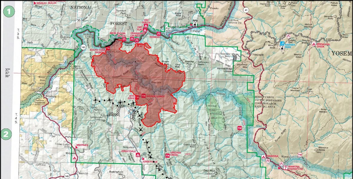
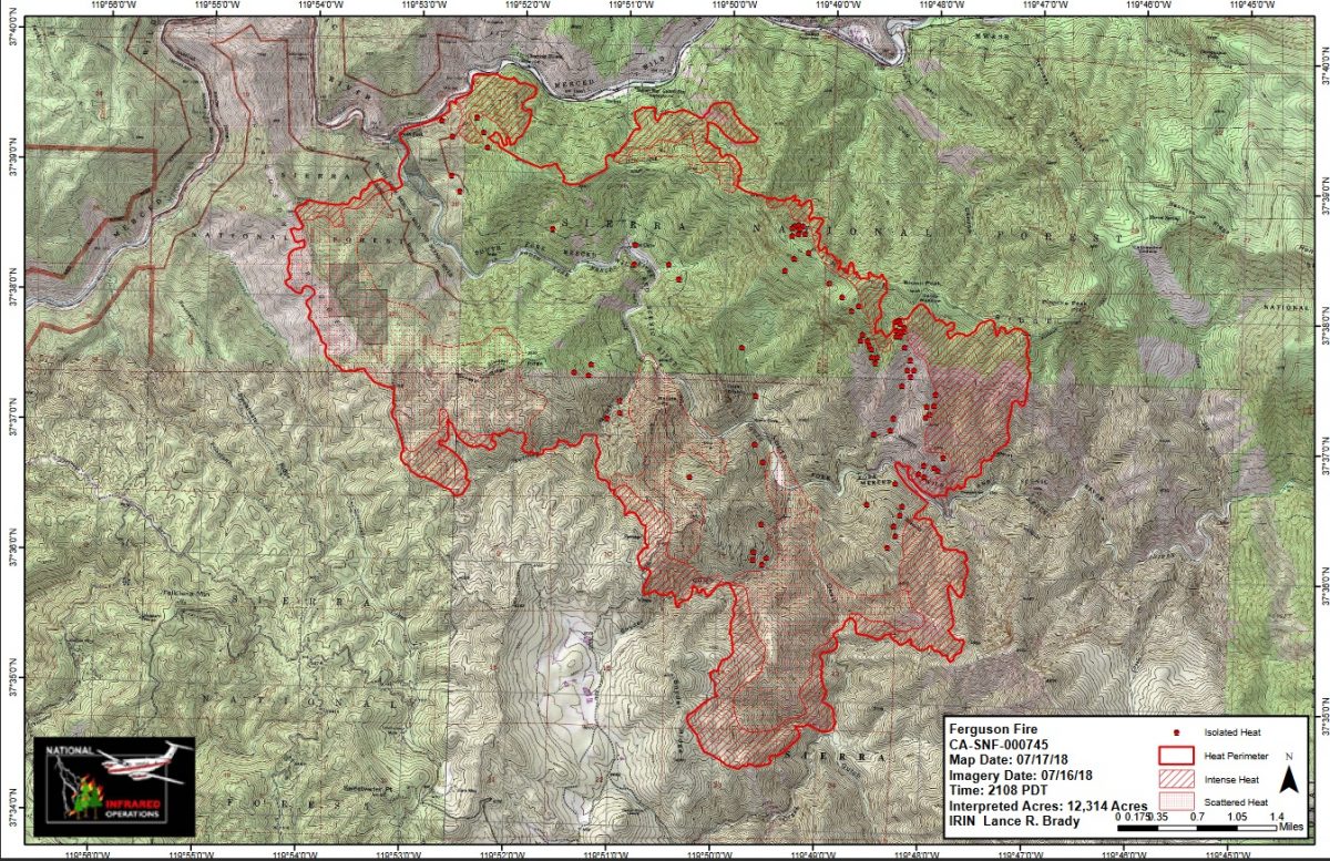
The fire is estimated at 12,525 acres with 5 percent containment.
Because the fire has now moved into Cal Fire’s areas of protection (State Responsibility Area), it is now under Unified Command with Cal Fire, US Forest Service and the Mariposa County Sheriff’s Office.
As the fire moves east and south, it will continue to threaten residences in the Jerseydale, Mariposa Pines, Clearing House and Incline areas.
Crews are fighting the fire aggressively, however very steep terrain makes it difficult to insert crews into certain areas of the fire.
The closure of State Route 140 east of Mariposa has closed the western entrance to Yosemite National Park.
Power lines that provide electric service to the Yosemite Valley were re-energized today restoring some service east of the fire including Yosemite National Park.
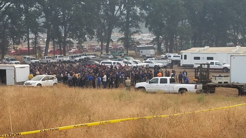
There are currently 1,486 personnel assigned to the incident including 118 engines, 39 crews, 16 dozers, 5 water tenders, 4 helicopters, and fixed-wing aircraft as conditions allow. Two VLATS, four LATS and four S2 air tankers will begin their work as soon as the inversion lifts.
Fire activity was fairly moderate overnight after an increase yesterday afternoon.
Near Cedar Lodge where firefighters have been using the road system behind the structure for a primary line, the fire backed down to that road. Crews did a burnout operation and were successful in holding that line.
The fire continued to back down to the roadway along Highway 140 from Pinoche Ridge towards Incline, but fire managers report there wasn’t a lot of growth there overnight.
On the northwest corner, most of the fire activity was along Ferguson Ridge near the dump. The fire rolled down to about mid-slope but fire managers report there was not a lot of rapid movement.
On the western perimeter, crews are continuing to strengthen contingency lines and do prep work along Sweetwater ridge.
North of Jereydale and Mariposa Pines the fire crested the ridge just above the communities. Crews are doing prep work in that area and formulating their firing plan. Day shift may be able to do burnouts in the Devil Gulch and Snyder Gulch area today to remove fuels. They will also continue to construct indirect line north and west around Mariposa Pines.
Dozer line is being cut across Henness Ridge as a contingency line to protect Yosemite West. Crews continue to work on structure protection in that community. Contingency line is also being cut from Pinoche Ridge to the Merced River, and from Wild Dove Road to Forest Road 4S04C.
The inversion is expected to hold until about 3 p.m., hampering air resources in their ability to operate safely over the fire.
Firefighters continue to deal with high temperatures across the fire area, with temperatures in the mid 90s on the ridge tops, and up to 102 degrees in the canyons. Humidity is forecast to drop as low as 15 percent by afternoon, with wind gusts 15 to 20 mph. Afternoon winds are a concern for sending embers spotting out ahead of the fire.
There will be a community meeting tonight, July 17, at 6 p.m. at the Wasuma School in Ahwahnee.
 The Incident Command Post for the Ferguson Fire has moved to the Ahwahnee Hills Regional Park. Please be aware of heavy fire equipment moving through the area.
There are currently 108 structures threatened including 70 homes, 3 commercial buildings and 35 outbuildings.
So far no structures have been lost and no injuries reported. There has been one fatality on the fire.
The Ferguson Fire started on Friday, July 13, at 8:30 p.m. The cause remains under investigation.
Evacuations
Mandatory evacuations are in place for
- Savage Trading Post
- Redbud Lodge
- Cedar Lodge
- Indian Flat Campground
- Mariposa Pines
- Sweetwater Ridge
- Ferguson Ridge
- Jerseydale including all residences on Jerseydale Road, Hites Cove Road and all side roads from Triangle Road to the end of Hites Cove Road.
- Incline Road from Clearing House to the Foresta Bridge in El Portal.
- The BLM campgrounds in Briceburg are closed until further notice.
Advisories have been issued for the following locations:
- National Park Service El Portal Complex
- Rancheria Flat – Government Housing
- El Portal Trailer Court
- Old El Portal
- Lushmeadows Community
- Ponderosa Basin Community
- Triangle Road from Jerseydale Road to Highway 49 South including all side roads
- Darrah Road from Triangle to Sherrod Road
- East side of Highway 49S from Darrah Road to Harris Cutoff Road – This includes Boyer Road, Woodland Area, Wass Road and Tip Top Road
- Yosemite West
Should these areas come under a mandatory evacuation order you will be notified via the Sheriff’s Office Emergency Alert System by text, email and a voice call, the Mariposa County Sheriff’s Office Facebook page, and door-to-door communication by Sheriff’s Office staff. At that time you will be notified of the best routes of travel to safely evacuate your residence.
A Red Cross Evacuation Center has been established at the New Life Christian Church located at 5089 Cole Road in Mariposa. If you have been evacuated due to the Ferguson Fire, the Sheriff’s Office asks that you please check in with the Red Cross Shelter even if you do not plan to stay there.
If you are in a Mandatory Evacuation or Advisory Area and may require assistance with evacuation transportation due to special needs or medical issues, please contact Human Services toll free at 1-833-423-0816 as soon as possible.
Planning ahead will help with a safe and timely evacuation.
Animal Evacuation Centers
Small Animal Shelter is at SPCA of Mariposa County, 5599 Highway 49 in Mariposa.
Large Animal Shelter is at the Mariposa County Fairgrounds, 5007 Fairgrounds Road in Mariposa.
Road Closures
Also closed are Jerseydale Road, Hites Cove Road and all side roads from Triangle Road to the end of Hites Cove Road; River Road from Briceburg to the gate at Railroad Flat and all campground areas are closed; Hites Cove Road from Bear Clover Road to the Merced River.
Cooperating Agencies include the Mariposa County Sheriff’s Office, CAL OES, California Highway Patrol, Caltrans, California Department of Corrections and Rehabilitation, American Red Cross, National Weather Service, California Conservation Corps, BLM and additional agencies throughout the state.