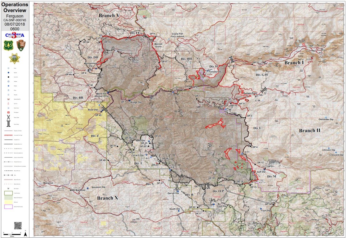
MARIPOSA COUNTY – The Ferguson Fire, estimated at 94,331 acres, is now the largest fire in the history of the Sierra National Forest, say officials, and is being managed as a full suppression fire. The fire is 43 percent contained. No growth in acreage was shown overnight.
The estimated date for full containment is Aug. 15.
Highway 140 is now open from Briceburg to the Yosemite National Park entrance. Yosemite Valley remains closed. Highway 120 is scheduled to open at 1 p.m. today (time has been updated from noon), allowing motorists to travel from the west across Tioga Pass. The Big Oak Flat Road remains closed. The El Portal area is now open with no restrictions.
Evacuation orders were lifted for Anderson Valley, Hall Gulch and Old Yosemite in the Greeley Hill Area as of 8 a.m.
Firefighters will take advantage of another day of expected moderate fire behavior. The moderate fire behavior is indicated by the lack of vertical movement of air, reducing the wind speed, solar heating and spot fires.
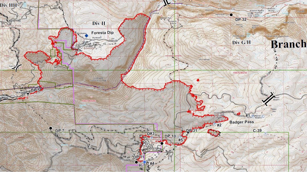
Firing operations along Highway 41 toward the Cascades Picnic Area on Highway 140 will continue today. Firefighters will patrol along Highway 120 to ensure the fire stays between Highway 41 and Highway 140. This tactical operation is to prohibit spread of the fire into the Yosemite Valley.
Preventing the spread of the fire farther into the Yosemite National Park and securing the communities of Foresta and Yosemite West remain the top priorities, say officials. Hand crews are reinforcing line in the drainage north of Foresta to keep the fire from becoming established and crossing containment lines. Firefighters are using an extensive network of hoses to bring water to the hot spots, mitigating the potential for spotting into the drainage.
Similar tactics are being used in the Badger Creek area, as firefighters use pumps and hoses to bring water to hot spots near the containment line. Dozers are working to complete the line east of Badger Pass, tying the fire into the 2013 Grouse Fire scar.
Crews have had success securing the northern and southern portions of the fire. Firefighters and heavy equipment are working on large portions of the fire perimeter repairing the containment lines cause by the suppression activities. Repairing of the containment lines is only possible where the fire is cooled and secure.
Tactical burning operations along Highway 41 to the north of Yosemite West on Aug. 4 were successful at a critical time of erratic fire behavior, say officials. Hazards such as rock slides and weakened trees continue to be a challenge for fire personnel along this stretch of road.
Structure defense specialists and law enforcement are still present within the remaining evacuated communities. The structure defense group in repopulated communities will be removing hoses, pumps and sprinklers today, as the threat of fire is reduced.
West of Wawona, crews continue to strengthen the lines and do mop-up so that those firefighters can be released to assist with other areas of the fire.
Along the southern perimeter and the western flank, everything remains within containment lines and restoration work has begun.
There are currently 2,357 personnel assigned to the incident including 202 engines, 39 crews, 18 water tenders, 33 dozers, 5 masticators, 14 helicopters, and fixed-wing tankers as conditions allow.
Officials report 995 structures threatened by the fire. Ten structures have been destroyed, though officials do not believe that any of those structures had been recently inhabited.
Damage assessment teams have been able to get into some of the burn areas of the fire, and report the 10 structures lost have been in the Ned Gulch area on the north end of the fire. Officials say it appears that the road had been washed out for some time, requiring teams to go on foot to assess the damage. We will provide more details as they become available.
There have been 12 firefighter injuries reported, and numerous instances of heat exhaustion-type symptoms. There have been two fatalities on the fire; HFEO Braden Varney was killed in a dozer rollover accident on July 14, and Brian Hughes, Arrowhead Hotshot Captain, lost his life on July 29 when he was struck by a tree during a firing operation.
Yosemite National Park
Officials have announced that the closure of some portions of Yosemite National Park will be extended indefinitely. The closure includes Hetch Hetchy. When the park does open these areas, limited visitor services will be available inside Yosemite Valley, including campgrounds, lodging, and food service operations.
Yosemite Valley has been closed since July 25 due to smoke impacts and for firefighting operations along El Portal Road and the Wawona Road.
The Mariposa Grove of Giant Sequoias and the Wawona Road (Highway 41) from the south entrance of Yosemite National Park to Tunnel View will remain closed until further notice.
The Big Oak Flat Road (Highway 120 West) to Crane Flat is closed. Tioga Road (Highway 120 East) from Crane Flat to Tioga Pass, remains open to all visitors and vehicles. All trails and campgrounds along Tioga Road, including the Tuolumne Meadows Campground remain open. All visitor services along Tioga Road, including the High Sierra Camps and visitor services near Tuolumne Meadows, remain open.
Non-essential personnel in Yosemite Valley were evacuated Friday due to hazardous road conditions, smoke and a loss of power, say park officials. Yosemite Valley has been closed to the public since July 25, however Yosemite National Park remains open on the east side out of Lee Vining, and Tioga Pass Road (Highway 120 East) provides access to the Tuolumne Meadows Visitor Center, the Pacific Crest and John Muir trails.
Yosemite National Park is working closely with the Incident Management Team and continues to assess park conditions daily.
For updated 24-hour road and weather conditions for Yosemite National Park, please call 209-372-0200, press 1 and press 1 again. Updated information is also available on the park’s website at www.nps.gov/yose and on the Yosemite National Park Facebook page.
Air quality issues
At 1 p.m. yesterday, Mariposa County reduced or closed services at many County departments due to unhealthy air quality both outside and inside some County offices. They plan to reopen today, Aug. 7. If you plan on visiting a County office over the next few days please call ahead to check the status of that office. Public Safety offices such as the Sheriff’s Office, Fire and EMS are not affected by this closure and remain fully staffed as usual. The Mariposa County Board of Supervisors meeting scheduled for Tuesday Aug, 7, at 9 a.m. will proceed as usual.
For information on air quality specific to Mariposa County visit http://www.mariposacounty.org/index.aspx?NID=1434. For additional information on air quality you can visit the AirNow website or the air fire smoke page.
The San Joaquin Valley Air Pollution Control District has also warned that a health caution is in place and smoke impacts will continue until the fire is extinguished.
Wildfire smoke is a mixture of gases and fine, microscopic particles that can cause health problems including triggering asthma attacks, aggravating chronic heart and lung diseases, and increasing the risk of heart attack and stroke. Where conditions warrant, people with heart or lung disease should follow their doctors’ advice for dealing with episodes of particulate exposure. People with existing respiratory conditions, young children and elderly people are especially susceptible to the health effects from these pollutants. Anyone being exposed to poor air quality or wildfire smoke should move inside to an air-conditioned environment.
Residents can check the San Joaquin Valley Air Pollution Control District’s wildfire page at www.valleyair.org/wildfires for information about any current wildfires and whether they are impacting the Valley. The District’s Real-time Air Advisory Network (RAAN) provides localized air quality data from an extensive air-monitoring network which allows Valley residents to track PM at any Valley address by visiting myraan.com.
If community members see new fire activity, they are asked to call 911, not the fire information line.
As of July 21, there are fire restrictions in place on the Sierra National Forest. Please read and be informed before you use any type of fire in the forest.
The Incident Command Post for the Ferguson Fire is located at the Ahwahnee Hills Regional Park. Please be aware of heavy fire equipment moving through the area. There is also a base camp set up on the Stanislaus National Forest. Personnel at the fire camp at Badger Pass have been relocated to the ICP in Ahwahnee due to active fire in the area.
Cal Fire exited Unified Command as of 6 a.m., Thursday, July 26, because of reduced threats to state and private lands. Cal Fire remains committed to the Ferguson Incident as an assisting agency. California Interagency Incident Management Team 3, led by Incident Commander Mark von Tillow, has assumed management of the Ferguson Fire as of 6 a.m. on Friday, Aug. 3, transitioning in for California Team 4, which had be managing the fire since July 19.
For information about the fire please call 530-377-6221.
The Ferguson Fire started on Friday, July 13, at 8:30 p.m., near Savage Trading Post on the south side of the Merced River canyon along Highway 140. The cause remains under investigation.
Area residents can expect to see increased smoke during the next few days as firing operations continue and the high pressure system over the fire weakens. Residents can monitor the latest air quality and health advisories at:
- https://wildlandfiresmoke.net/outlooks/YosemiteArea
- https://wildlandfiresmoke.net/outlooks/SouthernSierra
Stanislaus National Forest Supervisor Jason Kuiken has signed a forest order closing several Groveland Ranger District roads and trails impacted by the Ferguson Fire. This closure is based on the current and expected fire behavior and will be in effect until Sept. 30, or until replaced or rescinded. Click here for details and a map of the closure.
Be sure you are signed up to receive alerts when wildfire or other emergencies threaten.
- To sign up for the Mariposa Sheriff’s Office Emergency Alert System visit https://local.nixle.com/register.
- To register for the Madera County Sheriff’s Office Emergency Alert System visit mcalert.org.
Evacuations
New today: Highway 120 reopens at 1 p.m. The Big Oak Flat Road remains closed.
Evacuation orders lifted for Anderson Valley, Hall Gulch and Old Yosemite in the Greeley Hill Area.
Highway 140 is now open from Briceburg to Yosemite National Park. Yosemite Valley remains closed.
Mandatory evacuations remain in place for:
- Foresta
- Yosemite West
- Yosemite Valley
A Red Cross Evacuation Center has been established at New Life Christian Fellowship, 5089 Cole Road in Bootjack.
If you have been evacuated due to the Ferguson Fire, the Sheriff’s Office asks that you please check in with the Red Cross Shelter even if you do not plan to stay there.
If you are in a Mandatory Evacuation or Advisory Area and may require assistance with evacuation transportation due to special needs or medical issues, please contact Human Services toll free at 1-833-423-0816 as soon as possible.
Planning ahead will help with a safe and timely evacuation.
Animal Evacuation Centers
The Central California Animal Disaster Team (CCADT) has closed their emergency animal shelter at the Mariposa Elementary School, as all the pets have gone home. If you have small animals and have been evacuated, please call CCADT at 888-402-2238 ext. 0. If no one answers, leave a message. Someone will return your call as soon as possible.
Large Animal Shelter is at the Mariposa County Fairgrounds, 5007 Fairgrounds Road in Mariposa.
Road Closures
- Foresta Road
- Summit Road
- Highway 41 from the south gate of Yosemite to Yosemite Valley (Bridalveil Fall)
General information on returning to previously evacuated areas:
Mariposa County Sheriff’s Office will have a heavy presence in the area to ensure the security and safety of residents and businesses.
There will still be smoke in the respective areas as firefighters continue firefighting operations. If at any time you feel unsafe, please call 911.
For questions or concerns regarding power, please contact PG&E at 800-743-5000 or visit their website at www.pge.com.
The Mariposa County Health Department has health and safety information for residents returning to their homes on their website at http://www.mariposacounty.org/health or call 209-966-3689.
Mariposa County Health and Human Services will be available to assist residents with gaining additional services. Additional information regarding these and other services is available at www.mariposacountyrecovers.org.
SAFETY MESSAGE – The public is reminded to stay vigilant on current fire conditions. Please continue to adhere to road closures and any evacuation warnings. If you see electrical wires on the ground, stay clear and contact PG&E immediately. Trees and poles with deep charring, particularly if still smoking, should be considered hazardous. Please drive slowly and yield to emergency personnel in the area. As you re-enter your property and evaluate damage, be aware that hazardous conditions may exist, particularly if a residence or out-building has burned. Hazards may include asbestos, heavy metals, by-products of plastic combustion and various other chemicals. We encourage the public to remain prepared year-round for wildfires by visiting the www.readyforwildfire.org website. The best show of support is having your home and property “fire-ready.”
Cooperating Agencies on the Ferguson Fire include:
- AT&T
- Bureau of Land Management
- California Conservation Corps
- California Department of Corrections
- California Highway Patrol
- California Office of Emergency Services
- Cal Fire
- Caltrans
- Central Califonia Animal Disaster Team
- Hetch Hetchy Water & Power
- Madera County Sheriff
- Mariposa County Public Works
- Mariposa Public Works
- North Fork Rancheria of Mono Indian of California
- Pacific Gas and Electric
- Red Cross
- San Francisco Department of Emergency Management
- Sierra Tel
- Tuolumne County Sheriff
- Yosemite Mountain Ranch
Please note that the Public Information map does not reflect the opening of Highway 120 and 140 this morning.