 MARIPOSA COUNTY – Once again a day on the Ferguson Fire was one of contrasts as some residents were allowed to return home and others were evacuated.
The fire grew to 41,576 acres, with much of the push on the southern perimeter. The fire is 26 percent contained.
Overnight, there were multiple spot fires across the dozer line above Lushmeadows on the southwest face of Kirby Peak. As of noon today, those spot fires had morphed into one that was about 350 acres.
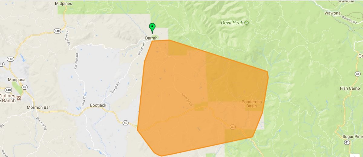
 The day started with the 5 a.m. evacuation of residents north of Triangle and East Westfall Roads. As the day progressed, and so did the fire, new evacuation orders were issued for the communities of Ponderosa Basin and Lushmeadows (see details below).
As crews got to work on the spot fires, more reports of slop-overs on the southern perimeter prompted “immediate need” call-outs for additional engines, crews and dozers.
With the southern breakout set as the priority for the day, all available resources focused their efforts there.
Though heavy helicopters were standing by ready to go by 7:30 a.m., dense smoke kept them grounded until late morning.
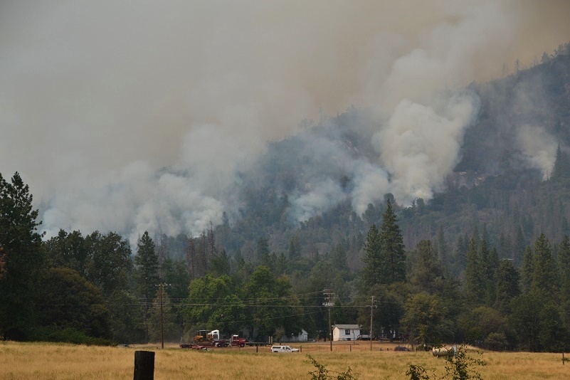
 The heavy inversion served the purpose of keeping the fire activity moderated throughout the morning, and the fire continued to back down the mountain toward dozens of structures all day, but no structures were damaged or lost. Over 5,200 are currently threatened by the Ferguson Fire.
There was a little more fire activity later in the afternoon when the inversion lifted, but there were no winds to fan the flames.
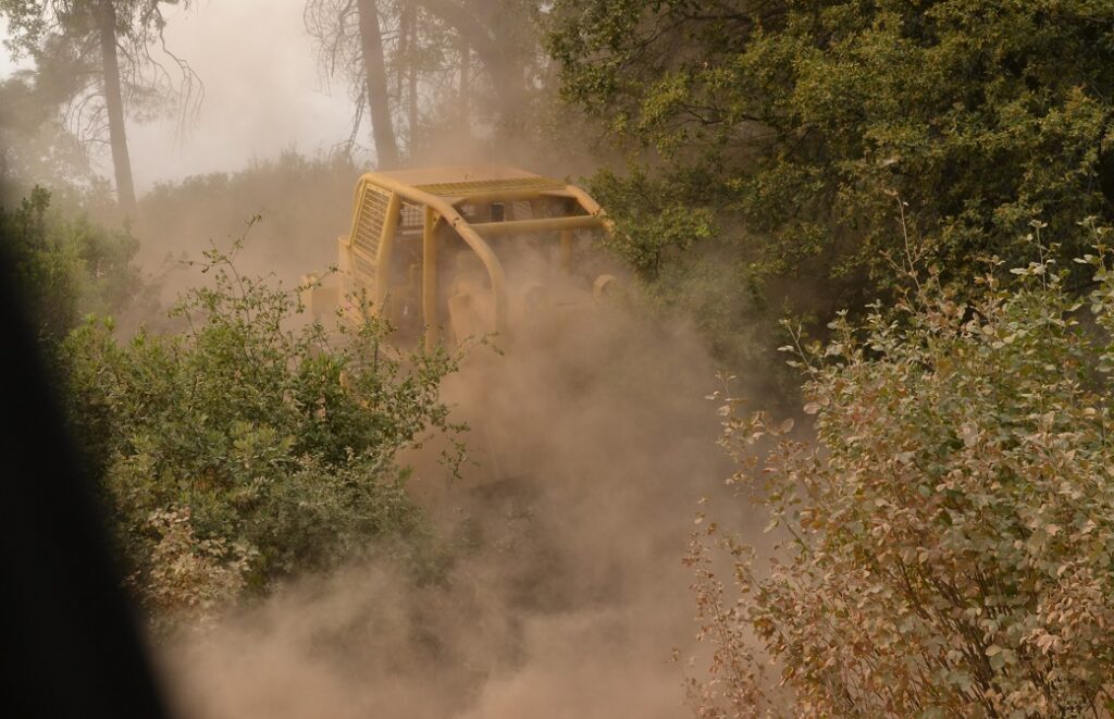
![]() At least half-a-dozen dozers cut line across the bottom of Kirby Ridge, helicopters and air tankers dropped water and retardant into the evening, and engines moved in to prep and provide structure protection for homes.
At least half-a-dozen dozers cut line across the bottom of Kirby Ridge, helicopters and air tankers dropped water and retardant into the evening, and engines moved in to prep and provide structure protection for homes.
The very steep slopes are covered with dead snags making it much too dangerous for direct attack, so dozers cut lines along both flanks and across the base of the mountain, and firefighters are bringing the fire down the slope to them.
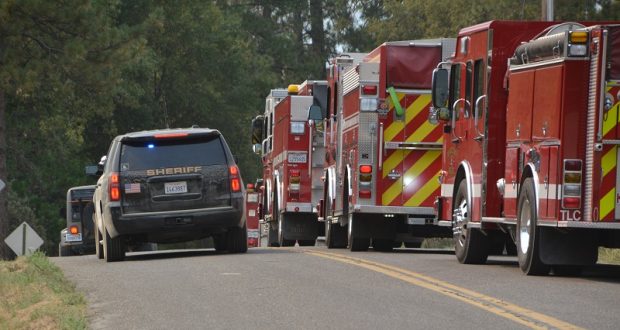
Sheriff’s deputies went door-to-door notifying residents of the evacuations and conducting heavy patrols, preventing anyone who shouldn’t be there from entering the closed areas.
In the Mariposa Pines area, the fireline to the north of that community is holding well, as is the one west across Sweetwater Ridge. Both were kept in check today and are looking really good, say fire officials. Evacuation orders for Jerseydale and Sweetwater Ridge Road were lifted this evening as of 6 p.m. (see details below).
 Mariposa Pines was repopulated at 6 p.m. yesterday. Crews continue to strengthen and expand firelines and the situation is being closely monitored.
Shortly after noon today, power was lost to 1,627 customers in the area. As of this posting PG&E is reporting 1,103 homes without power. There is no solid estimate on when power may be restored.
On the Stanislaus National Forest north of the Merced River, crews continued working on the line up from the river to Kinsley Station and Montgomery Ridge and across to Pilot Peak. The dozer line is complete from Five Corners to Pilot Peak. They are utilizing the burn scar of the Rim Fire to help build the “big box,” continuing down to Buena Vista. The line from El Portal up the park boundary is complete.
 South and east of El Portal, crews initiated firing operations yesterday at about 2 p.m. and burned down to the Barrel Spring area near Cathewood Saddle. Firefighters have about 500 feet of depth to that fireline now.
Fire managers say they will not progress any further until they’ve achieved their main priority of getting that part of the fire boxed off, and conduct firing operations down the ridge to remove fuels that may threaten El Portal. Once that work is complete, they will continue east.
Inside the park, crews and equipment are now able to move quickly and safely, as all visitors were required to leave by noon today and the south gate has been closed to the public.
Resources are working to tie the Empire and the South Fork Fires together so that if the fire does progress that far east, planners will have opportunities to utilizes those recent burn scars to their advantage.
The fireline is complete around the community of Wawona and hose lays are in, and all the structures have been assessed.
As prep work and structure protection continues in Yosemite West, crews completed the handline coming out of Wawona Campground and hose lays are in place. It’s tied in to the dozer line that runs west to Jerseydale, and crews continue to clean up that line, dropping hazard trees and making the line wider where needed.
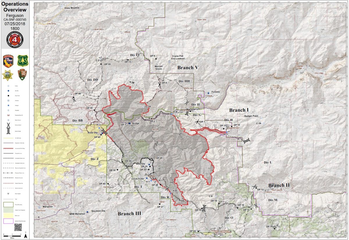
 To give a bit of the scope and complexity of this fire, during every briefing, morning and evening, an Incident Action Plan (IAP) is distributed along with a map of the fire that covers the “big box” – that includes the fire’s perimeter and all the areas that are part of the plan but may not have fire on the ground as of yet (and may never).
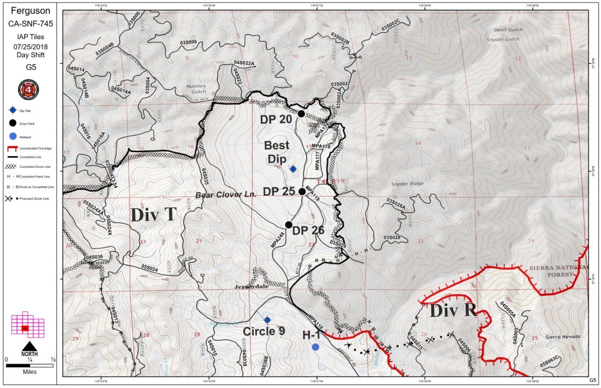 On day one, there was the IAP, and there was a map – on one sheet of paper. This evening’s IAP map was 35 pages. Big pages.
If a section of land is one square mile, each page represents an area nearly 5 miles wide and 4 miles deep.
There are currently 3,686 personnel assigned to the incident including 241 engines, 94 crews, 47 water tenders, 63 dozers, 18 helicopters, and fixed-wing tankers as conditions allow.
The forecast is for continued hot and dry weather, with humidity levels dropping.
Two Ferguson Fire community meetings are scheduled – one for Thursday, July 26, at the Mariposa County Fairgrounds Sequoia Hall, from 6 to 7 p.m.; a second on Friday, July 27, in Groveland and Tenaya Elementary School. Representatives from the Unified Command of Cal Fire, the U.S. Forest Service and the Mariposa County Sheriff’s Office will present an overview of the current situation and actions underway to contain the fire. Please arrive early as the meetings will start promptly at 6 p.m. If you have questions about the meetings, please call the Ferguson Fire Info Line at (530) 377-6221.
 The Glacier Point Road inside Yosemite National Park has been closed to accommodate firefighting resources and activities at a small base camp located at the Yosemite Ski and Snowboard Area (formerly Badger Pass) and Bridalveil Creek Campground (which is also closed).
The west entrance (El Portal) to Yosemite National Park on Highway 140 is closed.
Yosemite Valley and Wawona are closed to the public as of noon today. The closure is expected to last through Sunday, July 29. Highway 120 east and west remains open, along with Tuolumne Meadows. For information on Yosemite National Park, go to nps.gov/yose or call 209-372-0200.
As of July 21, there are fire restrictions in place on the Sierra National Forest. Please read and be informed before you use any type of fire in the forest.
The Incident Command Post for the Ferguson Fire is located at the Ahwahnee Hills Regional Park. Please be aware of heavy fire equipment moving through the area.
The fire is under Unified Command with Cal Fire, U.S. Forest Service, Yosemite National Park and the Mariposa County Sheriff’s Office. Management of the fire transitioned to a Type 1 Management Team – California Team 4 on Thursday, July 19.
There have been seven firefighter injuries reported, and several instances of heat exhaustion-type symptoms. There has been one fatality on the fire.
The Ferguson Fire started on Friday, July 13, at 8:30 p.m. The cause remains under investigation.
Smoke from the Ferguson Fire is impacting the Mariposa County Air Pollution Control District and across the region. For information specific to Mariposa County visit http://www.mariposacounty.org/index.aspx?NID=1434. For additional information on air quality you can visit the AirNow website or the air fire smoke page.
Residents can check the San Joaquin Valley Air Pollution Control District’s wildfire page at www.valleyair.org/wildfires for information about any current wildfires and whether they are impacting the Valley. The District’s Real-time Air Advisory Network (RAAN) provides localized air quality data from an extensive air-monitoring network which allows Valley residents to track PM at any Valley address by visiting myraan.com.
Evacuations
New today:
Lushmeadows, Ponderosa Basin, north of Triangle Road and north of East Westfall Road were place under a mandatory evacuation order this morning.
Evacuation orders for Jerseydale and Sweetwater Ridge Road were lifted this evening as of 6 p.m. The Jerseydale area will include the remainder of Jerseydale Road from Triangle Road to lower Best Road and all side roads in the Jerseydale Area. Sweetwater Ridge Road is located in the Midpines area. This area will be open to residents only and remain under advisory.
Mandatory evacuations are in place for:
- Savage Trading Post
- Redbud Lodge
- Cedar Lodge
- Indian Flat Campground
- Ferguson Ridge
- Incline Road from Clearing House to the Foresta Bridge in El Portal
- The BLM campgrounds in Briceburg are closed until further notice
- El Portal Trailer Park
- Old El Portal
- Rancheria Flat- Government Housing
- Foresta
- Yosemite View Lodge
- Yosemite West
- Anderson Valley
- Old Yosemite Road
- The north side of Triangle Road from Vista Lago to East Westfall and all side roads to the north
- The north side of East Westfall to Old Mill and all side roads to the north
- East Westfall Road to Chowchilla Mountain Road and all side roads
- Entire Ponderosa Subdivision
- Entire Lushmeadows Subdivisions
- Triangle Road from Darrah Road in the Lushmeadows area to Highway 49 South and all side roads
- Tip Top Road from Triangle Road to Gunther Road including Gunther Road
Advisories have been issued for the following locations:
- Darrah Road from Triangle to Sherrod Road
- East side of Highway 49S from Darrah Road to Harris Cutoff Road – This includes Boyer Road, Woodland Area and Wass Road
- Mariposa Pines on Scott Road from Best Road to the end of Hites Cove Road, including all side roads
- Highway 49 South from Stumpfield Mountain Road to the Mariposa/Madera County Line including Kimble Road
- Stumpfield Mountain Road
- Watt Road
- Jerseydale and Sweetwater Ridge Road
These areas are NOT under a mandatory evacuation order. This is an advisement only of a potential evacuation order should conditions change.
Should these areas come under a mandatory evacuation order you will be notified via the Sheriff’s Office Emergency Alert System by text, email and a voice call, the Mariposa County Sheriff’s Office Facebook page, and door-to-door communication by Sheriff’s Office staff. At that time you will be notified of the best routes of travel to safely evacuate your residence.
Red Cross Evacuation Centers have been established at:
- Mariposa Elementary School at 5044 Jones Street in Mariposa. This shelter is accepting small pets with their owners.
- Mountain Christian Center at 40299 Highway 49 in Oakhurst. They are not able to accommodate animals at this time. Please visit the shelter in Mariposa if you have small pets.
The shelter at New Life Christian Church located at 5089 Cole Road in Bootjack has been closed.
If you have been evacuated due to the Ferguson Fire, the Sheriff’s Office asks that you please check in with the Red Cross Shelter even if you do not plan to stay there.
If you are in a Mandatory Evacuation or Advisory Area and may require assistance with evacuation transportation due to special needs or medical issues, please contact Human Services toll free at 1-833-423-0816 as soon as possible.
Planning ahead will help with a safe and timely evacuation.
Animal Evacuation Centers
Small Animal Shelter is at SPCA of Mariposa County, 5599 Highway 49 in Mariposa is at full capacity.
Residents with small pets can be accommodated at the Mariposa Elementary School Shelter at 5044 Jones Street for those under mandatory evacuation, where Central California Animal Disaster Team (CCADT) is operating an emergency animal shelter. You must check in with Red Cross first. Please try to accommodate your pets with family and friends first, however your pet is welcome to be sheltered if necessary at the Mariposa Elementary School. For questions about pets, please call CCADT at 888-402-2238 ext. 0, and leave a message. Someone will return your call as soon as possible.
Large Animal Shelter is at the Mariposa County Fairgrounds, 5007 Fairgrounds Road in Mariposa.
Road Closures
Highway 140 is closed from the El Portal entrance gate to 14 miles north of Mariposa.
Wawona Road (Highway 41) between Chilnualna Falls Road in Wawona and Bridalveil Falls Road in Yosemite Valley will be closed beginning at noon today.
Also closed are:
- Triangle Road, from Darrah Road to Highway 49 south and all side roads
- Chowchilla Mountain Road at Highway 49 south
- Harris Road at Highway 49 south
- Tip Top Road from Triangle Road to Gunther Road
- All roads inside Lushmeadows Subdivision
- All roads inside Ponderosa Basin Subdivision
- Jerseydale Road
- Hites Cove Road (Mariposa Pines area)
- Hites Cove Road from Bear Clover Road to the Merced River
- River Road from Briceburg to the gate at Railroad Flat and all campgrounds
- Anderson Valley Road
- Old Yosemite Road
Cooperating Agencies include the Mariposa County Sheriff’s Office, Madera County Sheriff’s Office, CAL OES, California Highway Patrol, Caltrans, California Department of Corrections and Rehabilitation, American Red Cross, National Weather Service, California Conservation Corps, BLM and additional agencies throughout the state.