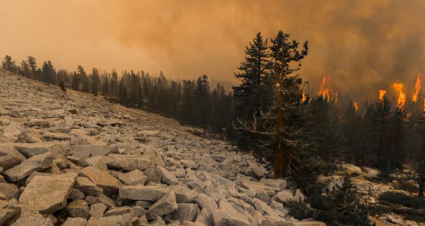
YOSEMITE – Sept. 25, 2020 – There are multiple fires burning in Yosemite National Park. Each fire is burning in Wilderness, in a fire adapted ecosystem. There are multiple trail closures in effect around Yosemite Creek and the southern part of the park. All fires may be visible from Tioga Road (Highway 120 through Yosemite National Park), Glacier Point, and high country vistas. Smoke from each fire is settling locally at night and in the morning then rising and dispersing to the north and northeast in the early afternoon. Park managers are working with the local Air Quality Districts to monitor smoke impacts to the park and local communities. Smoke from ongoing Southern and Central Sierra fires continue to impact the area.
Blue Jay Fire
Location: 4 miles south of White Wolf Campground and 1 mile west of Lukens Lake Trail at approximately 9,000 feet elevation.
Discovery Date: July 24, 2020
Size: 4,498 acres
Containment: 50%
Strategy: Confine and Contain
Cause: Lightning
Activity has diminished substantially due to cooler weather conditions and smoke inversion in the area. Primary direction of growth is to the north and northwest from Tioga Road at McSwain Summit. Unmanned Aircraft Systems (UAS) support for aerial reconnaissance and mapping, Infrared Detection (IR), and aerial ignition concluded this week. UAS support benefited firefighting operations immensely where firefighters could not access terrain on foot.
Wolf Fire
Location: 1 mile north of White Wolf Campground and 2 miles east of Lukens Lake Trail at approximately 9,000 feet elevation.
Discovery Date: August 11, 2020
Size: 1,087 acres
Containment: 35%
Strategy: Confine and Contain
Cause: Lightning
The fire has a 50% active perimeter, primarily on the southeastern edge. The fire is burning in dense pockets of vegetation and accumulated dead and down logs and is creeping along the forest floor, with some isolated single tree torching and short range spotting along the active perimeter.
North Whizz Dome Fire
Location: 4/10 mile south of Cathedral Creek and 1 mile northwest of Tioga Road at approximately 8,400 feet elevation.
Discovery Date: August 27, 2020
Size: 75 acres
Containment: 0%
Strategy: Monitor
Cause: Lightning
The fire has a 15% active perimeter, primarily on the western edge. The fire is burning in heavy fuels, ground litter, and pockets of accumulated dead and down logs with isolated single tree torching. Fire personnel will continue to monitor fire behavior and growth.
Horse Fire
Location: Horse Ridge, 1 mile southeast of Ostrander Lake at approximately 9,500 feet elevation.
Discovery Date: August 24, 2020
Size: 35 acres
Containment: 0%
Strategy: Monitor
Cause: Lightning
The fire is creeping and smoldering through sparse vegetation in a very rocky area. There are currently no threats to trails or infrastructure. Fire personnel will continue to monitor fire behavior and growth.
These updates will happen weekly unless significant activity occurs. For the most up-to-date fire information go to: Inciweb
-NPS-
- Air Quality: Yosemite Air Quality Page or airnow.gov or airnow.gov/fires
- Sign-up for Alerts: go.nps.gov/alert