CALIFORNIA — As strong winds remain in the forecast near the fires burning in Northern California, crews continue the grim task of locating and identifying those who perished in the flames.
The death toll has now risen to 31 across 4 fires, and officials expect that number to climb as hundreds are still unaccounted for.
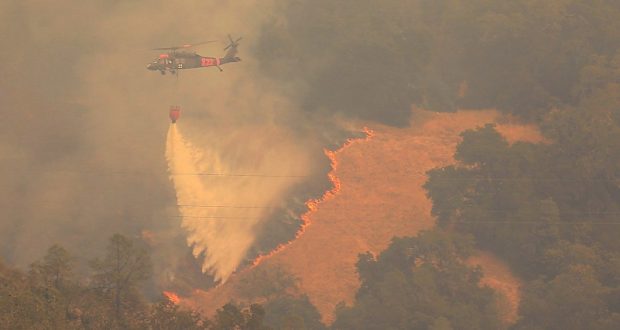
Overnight firefighters continued their battle against 17 wildfires that have burned 221,754 acres. Several of the wildfires merged with other fires, while full containment was made on three others – one in Kern County, one in Calaveras, and a third in Sonoma.
There are currently about 8,000 firefighters working round the clock, with more resources on order from other states. There are 10 engines and 2 hand crews from the Cal Fire Madera-Mariposa-Merced Unit assigned to fires in other units.
While several of the fires experienced winds overnight, they were relatively light, but a Red Flag Warning has been issued for later tonight when winds are expected to increase again, with gusts up to 45 mph .
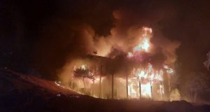
Some 3,500 homes and other structures have been destroyed.
Hundreds of additional fire engines and firefighters have begun to arrive from several other states, not only to help relieve crews on the front lines, but to be ready for the possibility of new wildfires that may ignite during the Red Flag Warnings.
With wildfire risk high, residents are urged to remain prepared for wildfires. Learn more by visiting www.ReadyForWildfire.org.
The cause of these fires remains under investigation.
**Cal Fire Incidents**
CENTRAL LNU COMPLEX (4 fires)
In unified command with Santa Rosa Fire Department & Sonoma County Sheriff
Cal Fire Incident Management Team assigned
17 civilian fatalities
Tubbs Fire
Sonoma and Napa Counties
Between Calistoga and Santa Rosa
34,770 acres, 25% contained
Significant number of structures destroyed
Pocket Fire
Sonoma County, Pocket Ranch Road and Ridge Ranch Road, Geyserville
9,996 acres, 5% contained
Nuns Fire
Sonoma County, north and west of Glen Ellen
44,381 acres, 5% contained
Overnight the Adobe Fire merged with the Nuns Fire, which also includes the previous Norrbom Fire.
Pressley Fire
Sonoma County. east of Rohnert Park
473 acres, 10% contained
SOUTHERN LNU COMPLEX (2 fires)
Cal Fire Incident Management Team assigned
Atlas Fire
Napa & Solano Counties, south of Lake Berryessa and northeast of Napa
8,228 acres, 27% contained
2 civilian fatalities
Significant structures destroyed
Partrick Fire
Napa County, west of Napa
12,379 acres, 18% contained
MENDOCINO-LAKE COMPLEX (2 fires)
Cal Fire Incident Management Team assigned
Redwood Valley, Mendocino County, north of Highway 20 in Potter Valley and Redwood Valley
34,000 acres, 10% contained
8 civilian fatalities
Significant structures destroyed
Sulphur Fire
Lake County, Clearlake Oaks
2,500 acres, 55% contained
WIND COMPLEX (4 fires)
Cal Fire Incident Management Team assigned
Cascade Fire
Yuba County, Loma Rica area
10,120 acres, 55% contained
4 civilian fatalities
Significant structure destroyed
Lobo Fire
Nevada County, Rough and Ready area
829 acres, 52% contained
Multiple structures destroyed
McCourtney Fire
Nevada County, southwest of Grass Valley
76 acres, 89% contained
LaPorte Fire
Butte County, Bangor area
6,059 acres, 25% contained
OTHER FIRES
Cherokee Fire
Butte County, north of Oroville
8,417 acres, 70% contained
Honey Fire
Butte County, southwest of Paradise
150 acres, 75% contained
Silver Fire
Fresno County, northwest of Squaw Valley
58 acres, 80% contained
Quarry Fire
Kern County, 5 miles southeast of Arvin
183 acres, 100% contained
Point Fire
Calaveras County
Highway 26 & Higdon Road, West Point
130 acres, 100% contained
37 Fire
Sonoma County
Highway 37 & Lakeville Highway near Skaggs Island
1,660 acres, 100% contained
**Unified Command Incidents**
Canyon 2 Fire
Orange County, Highway 91 & Gypsum Canyon Rd, Anaheim City
9,217 acres, 65% contained
Unified command with Cal Fire, Orange County, Anaheim and City of Orange
**Federal Incidents**
Ice Fire
El Dorado County, 13 miles east of Camino
US Forest Service – El Dorado National Forest
29 acres, 95% contained
(Photo credit @KentPhotos)