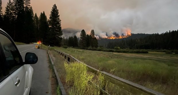
YOSEMITE NATIONAL PARK–The Washburn Fire is currently burning within the Yosemite National Park (YNP) boundary near the Mariposa Grove area. The Mariposa Grove is closed indefinitely. The community of Wawona has been evacuated including residents, employees and park guests. We will be adding updates to this article , please check back often. Helpful Links are at the bottom of the page.
Update 11:00am 7.13.2022
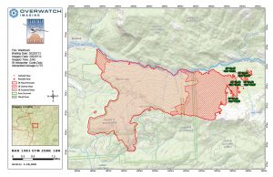
Washburn Fire heat map for 7.13.2022
The Washburn Fire is currently 17% contained and has burned 3,772 acres. Fire activity yesterday, 7.12.2022, afternoon was moderate and overnight the fire behavior stayed minimal.
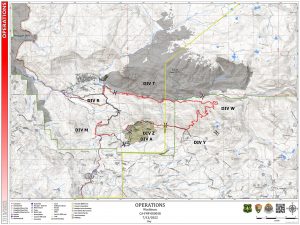
Washburrn Fire Operations Map 7.13.2022
Today’s objectives include to keep the fire north of Mt. Raymond Road, south of Wawona Dome, east of Wawona Rd and west of Star Lakes. Divisions A and Z are in mop up with interior burning present. Divisions M/R/T have “consumed available fuels”. The main is growth expected in Division’s Y and W with possible spotting south of Mt. Raymond.
The Incident Management Team (IMT) posted a video update this morning.
Helicopters have quick travel time between a helliwell, a portable water tank and the fire. Watch video.
Evacuations & Closures: The Wawona Road (Highway 41) is closed from the South Entrance to Henness Ridge Road. Yosemite West remains accessible from the northern side of the Wawona road. The Mariposa Grove are closed until further notice. A map of the evacuation area and current evacuation levels is available here.
Here is a link to another fire map of the incident. CALTOPO
Update 9:00pm 7.12.2022
At the end of day six as few as 3,500 acres have burned in the Washburn Fire. Perimeter containment is at 17%. Heavy available fuel loads, seasonally dry timber, and litter contribute to highly active fire behavior in uncontained portions of the fire. Continued warming and drying over the next several days will likely provide increased fire behavior with additional fire growth and smoke production.
HELPFUL LINKS
Inciweb official incident information
Deadwood Wildfire Alert Camera
Yosemite Fire and Aviation Facebook Page
To submit pictures and videos to Sierra News Online email news@sierranewsonline.com
Previous SNO articles
Yosemite Fire Grows Over 800 Acres
Yosemite Fire Remains Uncontained
Yosemite Fire Burns into Day 4
Washburn Fire Continues to Threaten Yosemite

