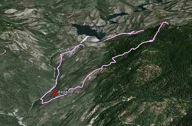
EASTERN MADERA COUNTY – The Aspen fire, located seven miles northwest of Big Creek, Ca, continues to be very active and has now consumed over 2,500 acres.
According to reports, the fire moved to the north during the night, and is about 1,000 feet above the shoreline on the east side of Mammoth Pool Reservoir
Campgrounds from Fish Creek and Rock Creek north, on the Madera County side of the San Joaquin River are being evacuated.
The evacuations on the west side of the river are precautionary only, as the fire has not jumped across, although a Forest Service spokesperson said that there is good potential for that to happen.
Campers in the Soda Springs area, China Bar, Sweetwater, Placer, Jackass Organizational, Little Jackass, and Lower Chiquito are also being told to leave the area.
Arnold Meadow is not being evacuated at this time, but campers are being put on notice to be ready to leave.
Road guards have been stationed in the area to control traffic, and Sheriff’s personnel will be letting people out, but not in (see info below) except to retrieve belongings from homes or cabins that they own.
 Personnel from the Minarets Ranger Station in North Fork will be posting informational signs along Mammoth Pool Road, variously known as Minarets Road (FR) 81, and Sierra Vista Scenic Byway (4S81).
Evacuations have also been ordered at Rancheria campground, Badger Flat and China Peak near Huntington Lake, in order to accommodate firefighters. Earlier evacuations were implemented at Sample Meadow and West Kaiser campgrounds.
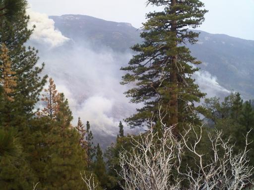
Air operations have been hampered throughout the day due to dense smoke. At this hour, there are reports of significant up-canyon winds and fire activity is picking up.
A helicopter cargo drop to the fire was postponed this afternoon due to limited visibility with the heavy smoke, but the Incident Commander has requested 6 helicopters for water drops when conditions allow.
The dense smoke can cause problems for those with sensitivities and breathing issues, and those affected are being urged to leave the area.
About 445 personnel are committed to the incident, and the fire is 0% contained, with a date for full containment given as July 31. There are no reports of injuries at this time, and currently three structures are threatened.
The Aspen fire is burning in very steep and dangerous terrain with the elevation ranging from 2,600 feet at the San Joaquin River, to nearly 7,000 near the leading of the fire.
(click photo to enlarge, Mammoth Pool Reservoir is in the north of the photo)
The Madera County Sheriff’s Office is in the process of closing down the following roads in the area, and have sent this update on road access near Mammoth Pool –
1) Forest 81 (Mammoth Pool/Minarets Road) south of Fish Creek campground – allow traffic to leave, no one allowed to go north, toward Mammoth Pool
2) Forest 81 south of the intersection of Grizzly Road – allow people to leave, no one allowed south on Forest 81, send traffic up Grizzly Road
3) Intersection of Forest Service Road 8S09 and 7S07 – allow people to leave toward North Fork, but not to enter
Cooperating agencies on the Aspen Fire include the US Forest Service, the California Highway Patrol, the Madera County Sheriff’s Office, and the Fresno County Sheriff’s Office. There was also a recent dispatch of Cal Fire transport dozers #4242 and 4245.