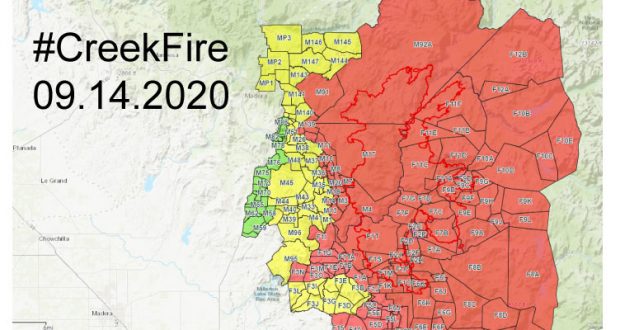
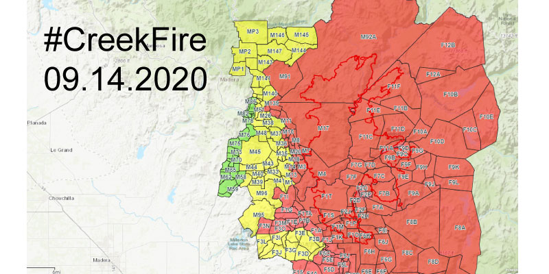
The following Mandatory Evacuation Order areas have been reduced to Evacuation Warnings. Zone M52 has been reduced to an Evacuation Warning. This zone will be open to residents only. You MUST have identification to enter this area. This zone includes the general area of Road 274 between Road 331 and Road 222 including Cowboy’s Trail. Road 222 between Road 274 and just east of Road 331 before the docks. Please see the Evacuation Map for specific details you will see this zone now in YELLOW.
The following Evacuation Warning Areas have been lifted.
Zones M49, M50 & M51 have been lifted, no restrictions remain. These zones include the general areas of Road 426 north of Golden Ball Drive and below John West Road including all intersecting road, Road 426 between John West Road and Johnson’s Place including all intersecting roads and John West Road between Road 426 and the end of Jean Road West including all intersecting roads. Please see the Evacuation Map for specific details- you will see those zones now in GREEN.
For specific questions about your zone please call (844) 668-3473.
Road Closures:
Road 632 at Buckskin Road
Road 274 just east of Road 331
Road 432 just east of Road 331
Road 222 at Bass Lake Dam
Road 222 at Road 221
Road 222 at Road 226
Road 225 at Road 274 (Roundabout)
Road 222 at Road 200.
The following are open to residents only:
Road 200 at Road 221
Road 426 at Road 223
Road 222 at Road 432.
What does Evacuation Warning Mean: This is NOT a Mandatory Evacuation Order. This is to inform you there is/remains a potential threat to life and property. Please monitor the situation and be prepared to take action immediately should conditions change. However, don’t wait for an evacuation order to leave if you feel threatened.
What does Mandatory Evacuation Order Mean: There is an immediate threat to life. This is an evacuation order to leave now. The area is being closed to public access. Take action immediately. If you’re in need of evacuation assistance, call 9 1 1
Spoiled Food
Residents returning home that have spoiled food can dispose of that food at the Oakhurst Sheriff’s Office Sub Station located at 48267 Liberty Drive, Oakhurst.
Bagged household garbage only will be accepted. Bear activity around the fire area has limited the location where dumpsters can be placed. Food that has been left in a refrigerator after four hours without power should be thrown out. All food that may have been warmed and re-cooled should also be thrown away. Remember, when in doubt, throw it out!
Department of Social Services
Oakhurst DSS office is open for families needing support services. Please call 559-675-2300.
Creek Fire Information Resources
Creek Fire Information- (844) 668-3473
Madera County Residence Only- Dial 311
Madera County Information- https://www.facebook.com/MaderaSheriff
Creek Fire Incident Page- https://inciweb.nwcg.gov/incident/7147/
CAL FIRE Creek Fire Incident Page- https://www.fire.ca.gov/incidents/2020/9/4/creek-fire/
Sierra National Forest Information- https://www.facebook.com/SierraNF/
FIRE SAFETY MESSAGE: The public is reminded to stay vigilant on current fire conditions. Please drive carefully and watch for fire suppression equipment work in the area. The Creek Fire is still an active incident. Please continue to adhere to road closures and safety advisories. If you see electrical wires on the ground, stay clear and contact PG&E immediately. Please drive slowly and yield to all emergency and safety personnel who will continue to be working in the area for the duration of the incident. Please remember a large amount of traffic related to the fire may still be in the area.