YOSEMITE — The South Fork Fire, burning on the southern end of Yosemite National Park just east of the community of Wawona, is now being estimated at 900 acres with 0 percent containment.
Air recon of the South Fork Fire this morning provided the new estimated acreage.
The growth was primarily north-northeast with some backing down the South Fork drainage. The retardant line on the west edge of the fires slowed progression but needs to be followed up with hand crews.
Crews will work to establish an anchor point and work the fire’s western edge to prevent further spread to the west.
The fire is burning in wilderness but is being managed for protection objectives due to its close proximity to Wawona.
Firefighters are dealing with difficult terrain, extreme fire behavior, group torching, short crown and uphill runs.
There are currently 25 personnel assigned to the incident, along with air resources.
Residents and visitors in the Wawona area are warned to make appropriate pre-evacuation preparations.
If there is an actual need for evacuation, there will be door-to-door notifications by park staff.
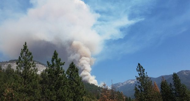
Heavy smoke is impacting the areas surrounding Yosemite, especially overnight and through the morning hours, adding more smoke to what is being produced by the Empire Fire near Bridalveil Campground, which is now estimated at 1,200 acres.
Air quality in Wawona is expected to be extremely smoky and to reach unhealthy/hazardous conditions through noon today.
Smoke from the South Fork Fire is expected to fill the canyons west of Wawona to Mariposa. It is also expected to affect visibility along Highway 140 from El Portal to Mariposa, Wawona Road south to Fish Camp, and roads along Tioga Pass to the Mono Lake area.
Recommendations:
– Close windows and doors to keep smoke out.
– Consider leaving the area if you have the option.
The fire is burning in a rugged wilderness area, and the cause is under investigation.
We will update as new information becomes available.
Click here for an interactive map.