MARIPOSA COUNTY – As some residents on the south end of the Ferguson Fire were allowed to return home, visitors in Yosemite National Park were told to pack up and leave.
Just after 1 p.m. today, park officials announced that Yosemite Valley and Wawona will close at noon tomorrow, July 25, to all visitors in all hotels and campgrounds due to the ongoing impacts of the fire. These closures also include visitor services in Yosemite Valley and Wawona. Click here for the details.
Then at 6 p.m., the Mariposa County Sheriff’s Office announced that evacuation orders had been lifted for some Mariposa Pines residents, including those on Scott Road from Best Road to the end of Hites Cove Road, including all side roads. These areas will remain under advisory and the area will be open to residents only.
Mariposa County Sheriff’s Office will have a heavy presence in the area to ensure the security and safety of residents and businesses. Due to the large amount of emergency equipment in the area, speed control will also be enforced. For complete details, click here.
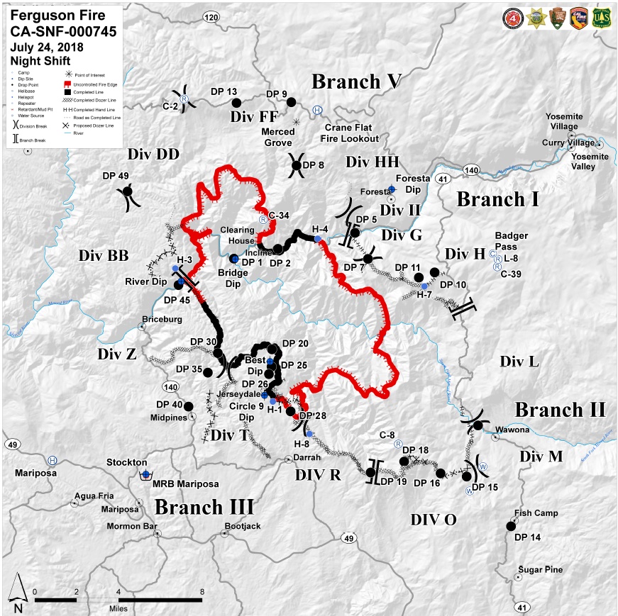
The fire is now estimated at 37,795 acres with 26 percent containment.
Of the nearly 3,500 structures threatened over the 11 days since the fire started, just one non-residential structure has been destroyed. No new evacuations have been ordered since Sunday afternoon.
The hard work of firefighters in the Jerseydale/ Mariposa Pines area has saved 108 homes. Those firelines continue to be strengthened and crews remain in the community protecting structures and doing mop-up. Fire managers are working very closely with the Mariposa County Sheriff’s Office to repopulate the rest of the area very soon.
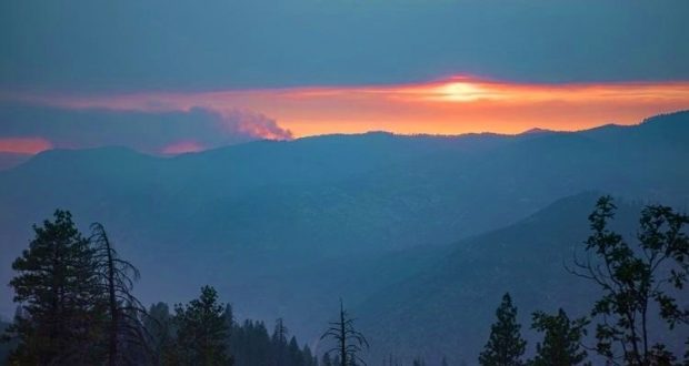
Firing operations continued from Footman Ridge east today. There was a pretty good firefight in that area yesterday, but crews did a great job of getting it contained. By noon today the air had cleared enough to allow for some helicopter work as crews continued their firing operations above the Jerseydale fire station.
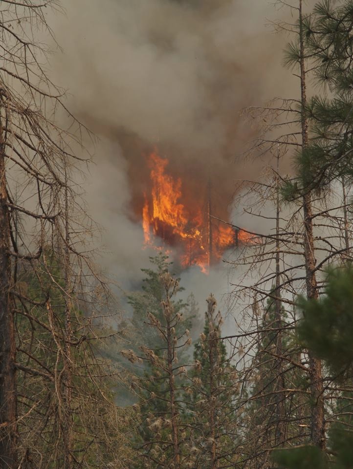
Firing operations behind the Jerseydale Ranch – photo Jerseydale Ranch Facbook
Folks at the Jerseydale Ranch posted this on Facebook yesterday:
“Today they completed the backburn of the bulldozer line behind Jerseydale Ranch. They will continue to monitor the line for the next few days, but we should be out of danger. Today was busy here with helicopters flying right over head all day, water tenders in and out of the parking lot 24 hours a day, and fire crews accessing the bulldozer line from the back of our ranch.”
Just after 2 p.m. today, crews began firing operations in the Henness Ridge area to remove fuels as the fire pushes toward Yosemite West. The plan is to work it down to the Cathewood Road area. They fired from both sides of Zip Creek, creating a buffer and an anchor point in preparation for the fire to come up the creek. Managers say this will be a 48-hour process as they work to achieve good fire affects in that area.
Firefighters always like the fire to burn on their terms, and managing a fire of this size is a well-thought-out process with days of planning to achieve the best results.
By 2:15 p.m., visibility had cleared in most areas of the fire and burning operations began in several divisions. It also allowed aircraft to do their work.
In Yosemite West, prep work has been completed and engines and crews are staged throughout the community for structure protection.
Inside Yosemite National Park, east of Highway 41, fire personnel have scouted, identified and cut contingency lines utilizing the old burn scars of the Empire and the South Fork Fires. A structure specialist and engines were put in place in Wawona today to ensure the line is secure.
The line is completed from west of Wawona Campground south to the Chowchilla Mountain Road, and there is dozer line all the way back across to Jerseydale. Crews continue to clean up and prep that line.
Along Sweetwater Ridge on the west flank, everything is holding well, and crews continue to strengthen lines and do mop-up.
On the northwest corner, burning on the Stanislas National Forest, there was not much fire activity today. Contingency line is complete up through Jenkins Hill to Soapstone and crews will finish tying in to Montgomery Gulch tonight, toward the burn scar of the Rim Fire. Crews continue their work to complete the line to Pilot Ridge, and are improving line along the road system headed up toward the Tuolumne Grove.
From Pilot Ridge the line runs down to Buena Vista. The line from Buena Vista to Eagle Peak is already tied in and handline has been completed down into El Portal.
Fallers are dropping hazard trees along those lines and getting them prepped in case they have to conduct firing operations in that area. Once all the contingency lines are prepped and ready, managers will look for opportunities to attack the fire directly wherever possible.
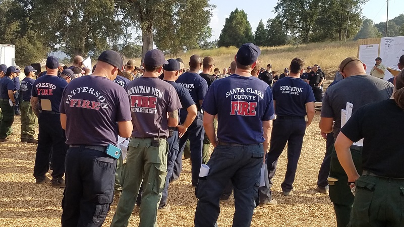
Firefighters from six different agencies at evening briefing – photo Gina Clugston
There are firefighters from hundreds of different agencies, municipalities and forests across the region working this fire. One photo capturing a small group at an evening briefing shows six agencies represented.
There are currently 3,434 personnel assigned to the incident including 220 engines, 88 crews, 47 water tenders, 59 dozers, 16 helicopters, and fixed-wing tankers as conditions allow.
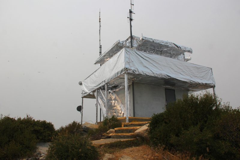
Signal Peak lookout wrapped for protection – photo USFS
The Signal Peak lookout tower (Devils Peak) has been wrapped with a fire-resistant aluminum barrier. The material is said to reflect 95 percent of the radiant heat and eliminate the exposure of areas where embers might lodge and start smouldering. The shields are secured with heat-stable adhesive tape.
There will be a community meeting on the Ferguson Fire at 6 p.m. on Wednesday, July 25, in Greeley Hill at the Greeley Hill Community Center.
As of July 21, there are fire restrictions in place on the Sierra National Forest. Please read and be informed before you use any type of fire in the forest.
The Glacier Point Road inside Yosemite National Park has been closed to accommodate firefighting resources and activities at a small base camp located at the Yosemite Ski and Snowboard Area (formerly Badger Pass) and Bridalveil Creek Campground (which is also closed).
The west entrance (El Portal) to Yosemite National Park on Highway 140 is closed, as will be Yosemite Valley and Wawona by tomorrow at noon. The closure is expected to last through Sunday, July 29. Highway 120 east and west remains open, along with Tuolumne Meadows. For information on Yosemite National Park, go to nps.gov/yose or call 209-372-0200.
The Incident Command Post for the Ferguson Fire is located at the Ahwahnee Hills Regional Park. Please be aware of heavy fire equipment moving through the area.
The fire is under Unified Command with Cal Fire, U.S. Forest Service, Yosemite National Park and the Mariposa County Sheriff’s Office. Management of the fire transitioned to a Type 1 Management Team – California Team 4 on Thursday, July 19.
There have been six firefighter injuries reported, and several instances of heat exhaustion-type symptoms. There has been one fatality on the fire.
The Ferguson Fire started on Friday, July 13, at 8:30 p.m. The cause remains under investigation.
Smoke from the Ferguson Fire is impacting the Mariposa County Air Pollution Control District and across the region. For information specific to Mariposa County visit http://www.mariposacounty.org/index.aspx?NID=1434. For additional information on air quality you can visit the AirNow website or the air fire smoke page.
Residents can check the San Joaquin Valley Air Pollution Control District’s wildfire page at www.valleyair.org/wildfires for information about any current wildfires and whether they are impacting the Valley. The District’s Real-time Air Advisory Network (RAAN) provides localized air quality data from an extensive air-monitoring network which allows Valley residents to track PM at any Valley address by visiting myraan.com.
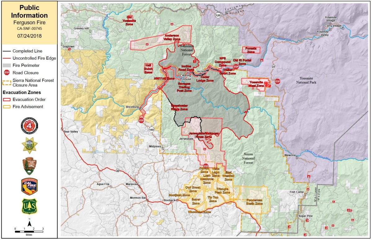
Evacuations
Mandatory evacuations are in place for:
- Savage Trading Post
- Redbud Lodge
- Cedar Lodge
- Indian Flat Campground
- Sweetwater Ridge
- Ferguson Ridge
- Jerseydale including all residences on Jerseydale Road, and all side roads on Hites Cove Road from Triangle Road to Best Road
- Incline Road from Clearing House to the Foresta Bridge in El Portal
- The BLM campgrounds in Briceburg are closed until further notice
- El Portal Trailer Park
- Old El Portal
- Rancheria Flat- Government Housing
- Foresta
- Yosemite View Lodge
- Yosemite West
- Anderson Valley
- Old Yosemite Road
Advisories have been issued for the following locations:
- Lushmeadows Community
- Ponderosa Basin Community
- Triangle Road from Jerseydale Road to Highway 49 South including all side roads
- Darrah Road from Triangle to Sherrod Road
- East side of Highway 49S from Darrah Road to Harris Cutoff Road – This includes Boyer Road, Woodland Area, Wass Road and Tip Top Road
- Mariposa Pines on Scott Road from Best Road to the end of Hites Cove Road, including all side roads
These areas are NOT under a mandatory evacuation order. This is an advisement only of a potential evacuation order should conditions change.
Should these areas come under a mandatory evacuation order you will be notified via the Sheriff’s Office Emergency Alert System by text, email and a voice call, the Mariposa County Sheriff’s Office Facebook page, and door-to-door communication by Sheriff’s Office staff. At that time you will be notified of the best routes of travel to safely evacuate your residence.
A Red Cross Evacuation Center has been established at the New Life Christian Church located at 5089 Cole Road in Mariposa. If you have been evacuated due to the Ferguson Fire, the Sheriff’s Office asks that you please check in with the Red Cross Shelter even if you do not plan to stay there.
If you are in a Mandatory Evacuation or Advisory Area and may require assistance with evacuation transportation due to special needs or medical issues, please contact Human Services toll free at 1-833-423-0816 as soon as possible.
Planning ahead will help with a safe and timely evacuation.
Animal Evacuation Centers
Small Animal Shelter is at SPCA of Mariposa County, 5599 Highway 49 in Mariposa.
Large Animal Shelter is at the Mariposa County Fairgrounds, 5007 Fairgrounds Road in Mariposa.
Road Closures
Also closed are Jerseydale Road, Hites Cove Road and all side roads from Triangle Road to the end of Hites Cove Road; River Road from Briceburg to the gate at Railroad Flat and all campground areas are closed; Hites Cove Road from Bear Clover Road to the Merced River, Anderson Valley Road and Old Yosemite Road.
Cooperating Agencies include the Mariposa County Sheriff’s Office, Madera County Sheriff’s Office, CAL OES, California Highway Patrol, Caltrans, California Department of Corrections and Rehabilitation, American Red Cross, National Weather Service, California Conservation Corps, BLM and additional agencies throughout the state.