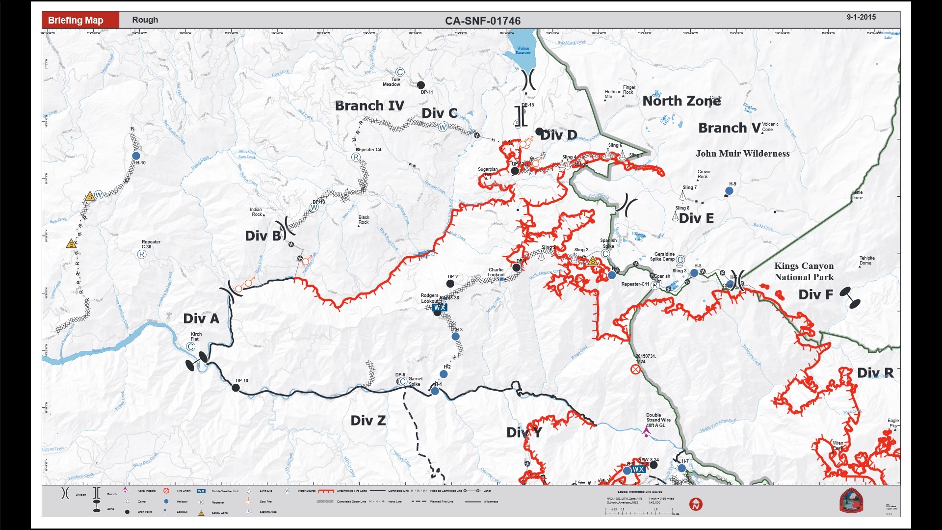
SIERRA NATIONAL FOREST – The Rough Fire has grown to 77,287 acres and is currently the largest active fire in California. About 47,907 acres are on the Sierra National Forest, 29,110 acres on the Sequoia National Forest, 207 acres on Sequoia and Kings Canyon National Park and 62 acres of state responsibility.
There are 2,040 personnel currently assigned to the incident. Containment remains at 25 percent. There are no evacuations or evacuation warnings in effect.
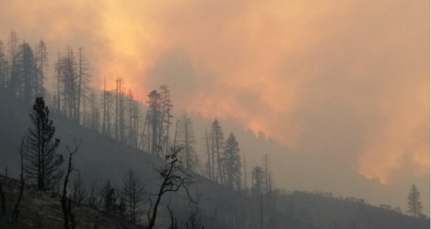
 Heavy concentrations of smoke are expected near the fire today. Unhealthy conditions are expected in low lying areas and with very light transport winds, smoke is expected to remain in drainages until early afternoon, if not longer. Smoke is expected to again settle into Kings Canyon, and low lying areas near the fire such as Hume Lake and Cedar Grove this evening, with Unhealthy to Very Unhealthy conditions expected.
Firefighters are evaluating opportunities for fire line rehabilitation and repairs. The primary locations being considered are along the contingency lines. The first suppression repair actions are to build water bars to prevent erosion from future water runoff and snow melt.
 The fire is expected to move toward the east and has reached Lewis Creek in the Monarch Wilderness. When wind and topography are in alignment, the fire has the potential to make long runs north into Little Tehipite Valley in the northeast.
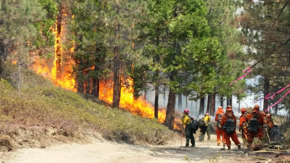
Firing operations last night were successful in the southwest portion reaching south toward Buck Rock. Firing continued in the Converse Valley until rising humidity levels prevented the fire from burning adequately.
Structure defense preparation continues around the Cedar Grove area as a precaution. Fire officials say this area has been staffed with highly qualified, extremely effective crews used in a variety of fire operations including basic suppression, extremely accurate fire behavior analysis, and other tactical predictive services.
 U.S. Forest Service mules from the Sierra National Forest have been assigned to the north side of the Rough Fire. The USFS has utilized pack strings since their inception over 100 years ago. Today, pack strings still work in our public lands to support fire crews, trail crews and other resource-related entities that perform their duties within roadless areas.
While firefighters make the final push towards containment of the fire theater, they must fulfill another extremely important task and be on the lookout for equipment in the field that is no longer needed by the crews that fought before them. They must recover and return items as activities continue to wind down in those areas.
The list of equipment that must be retrieved includes hose, pump kits, generators, chainsaw kits, collapsible water tanks and smaller items such as hose fittings and nozzles. To gather these items, firefighters will GPS the location of equipment and then crews are sent out to back-haul these items. Equipment must then cleaned, repaired, and organized to be ready for the next incident.
Decreased fire activity provides an opportunity for crews to work on lines in those areas. Wildland Fire Modules are operating in the wilderness area, and mule pack strings are supporting these units to limit helicopter flights due to decreased visibility.
Yesterday, PG&E re-energized the power from Hass Power House near Black Rock to Wishon Reservoir through the Woodchuck lines. All power generated through Balch Camp supplying the Central Valley is energized.
 Firefighters continue burn operations from Buck Rock north to Burton Pass. Lines have been reinforced east toward Little Boulder Creek, and work is progressing toward the footprint of the Sheep Fire that occurred in 2010.
The fire has primarily been surface burning, although areas with jackpots of beetle killed trees have exhibited extreme fire behavior with up to 130 ft. flame lengths.
Work continues on the line along Hoist Ridge toward Kings River. Air Operations has been pre-treating the line with water and retardant drops with a variety of helicopters and fixed wing aircraft including the Very Large Air Tanker (VLAT). Crews will continue burning to the west, removing fuel from in front of the fire.
With temperatures increasing in the afternoon, fire officials anticipate that the eastern section of Little Tehipite Valley will experience increased fire activity again.
The fire progresses northeast toward Stag Dome above Cedar Creek and east along the King River.
The Buck Rock Lookout is located in the Giant Sequoia National Monument, between Sequoia and Kings Canyon National Parks. From a distance the lookout appears to be a small shack teetering atop a rock hundreds of feet above the surrounding forest. On July 31, the Buck Rock lookout was first to report the lightning-caused Rough Fire at 7:33 p.m.
On Tuesday, Aug. 18, the Rough Fire spotted across the South Fork of the Kings River and crossed highway 180 in the area of Horseshoe Bend and became established in the Lockwood Creek Drainage. As a result of the fire crossing the river, the pre-planned evacuation of the Hume Lake area was implemented. Over 2,500 campers, hikers, employees, and residents were notified and safely evacuated from Hume Lake Christian Camp, private cabins, campgrounds, and the surrounding area in just over 2 ½ hours.
Closures & Advisories
- Sierra National Forest closure order for the Rough Fire area remains in effect.
- The Hume Lake Ranger District, Jenny Lakes Wilderness and Monarch Wilderness, including Forest Road 12S01, 12S01E, and 12S19 in the Sequoia Highlands area of the Sequoia NationalForest remain closed.
- McKinley Grove Rd. (11S40) is closed at Wishon Dam, including the 11S07.
- 10S24 is closed from the intersection of 11S91 to where it meets 11S40 at Buck Meadow.
- 11S12 Rd. (Salt Flat Rd.) is closed at McKinley Grove Rd.
- Trimmer Springs Road is closed at Kirch Flat.
Parts of the Grant Grove and Wilsonia areas of Kings Canyon National Park are now open. The General Grant Tree, Panoramic Point, John Muir Lodge, Grant Grove Cabins, Visitor Center, park trails, restaurant, market and gift shop are now open to residents and visitors.
As the fire spread, existing closure orders were expanded to include almost the entire Hume Lake Ranger District. The current closure is defined in Forest Order 15-19, which closes these areas for public safety:
• most of the Hume Lake Ranger District from Delilah Rd. on the west to Jennie Lakes and Monarch Wildernesses to the east; and from Hwy 180 in the south to the Forest boundary to the north. (see included map); Sequoia & Kings Canyon National Parks issued a closure of the Cedar Grove area and the Grant Grove area.
• Sierra National Forest issued a closure order for the Rough Fire Area.
• Black Rock Campground and Forest Road 11S12 (also called Black Rock Road) is closed between Balch Camp and McKinley Road.
• Sequoia National Forest issued a closure order for the Hume Lake Ranger District, Jenny Lakes Wilderness and Monarch Wilderness, including Forest Road 12S01, 12S01E, and 12S19 in the Sequoia Highlands area.
• The Hume Lake recreation area is closed, as is Hwy 180 beyond the junction of Hwy 198 (Generals Highway).
Fire Restrictions are in place for the Sierra National Forest. Campfires are only allowed in designated developed recreation sites.
Source: http://inciweb.nwcg.gov/incident/4456/