
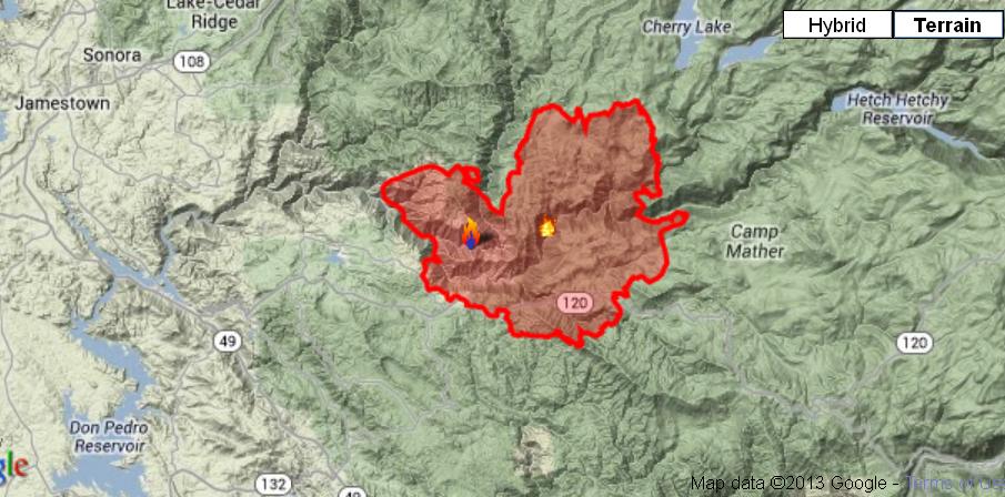
TUOLUMNE COUNTY – The Rim Fire has now crossed into Yosemite National Park, and has grown from just over 63,000 acres yesterday to 105,620 as of 9:30 a.m. this morning, with 2% containment.
Seven more structures were lost overnight, bringing the total to 16. Another 4,500 are threatened, and evacuations have been ordered for the area north of Ferretti Road to Elderberry Road. An evacuation advisory has been issued for the community of Pine Mountain Lake.
Communities along Ferretti Road from Highway 120 to Pine Mountain Road, and Highway 120 at the Yosemite National Park boundary west to Smith station have been evacuated. An evacuation center has been set up at the Mother Lode Fairgrounds in Sonora.
Highway 120 is closed to all inbound and outbound Yosemite National Park traffic, four miles west of Groveland Ranger Station and four miles east of Buck Meadows, and Ferretti Road has been closed.
A community meeting is scheduled today, Friday, Aug. 23, at 7 p.m., at Tenaya School, 19177 Hwy 120, Groveland, CA. Members of the Incident Management Team will present an update on the current fire situation and plans for the immediate future, and will be available for questions.
 Over 2,000 personnel have now been assigned to this incident, and access to the fire is still a concern for fire crews and equipment, with firefighter and public safety remaining the highest priority.
The Rim Fire, which was discovered on Aug. 17, is located within the Stanislaus National Forest on the Groveland Ranger District, and is burning in heavy brush, oak and pine, on inaccessible, steep and rugged terrain. Fire officials classify its growth potential as “extreme.”
The fire continues burning west toward the community of Pine Mountain Lake. Direct suppression efforts are taking place in the vicinity of communities and firefighters are staged to defend structures in the area.
Fire managers plan to continue the heavy use of air tankers throughout the day. Direct line suppression efforts are impeded by difficult access and steep inaccessible terrain.
Evacuations:
The following areas are currently under evacuation advisory: Evergreen Lodge, San Jose Family Camp, Yosemite Riverside Inn, Spinning Wheel, Rainbow Pool, Buck Meadow, Yosemite Vista Estates, Ferretti to Clements Rd., Berkeley Family Camp, Harden Flat, Naco West, Yosemite Lakes, Pine Mt. Lake, and Packerd Canyon.
The Tuolumne County Sheriffs Office has issued an evacuation order for residents north of Ferretti Road to Elderberry Road. An Evacuation Order is issued when there is an immediate threat to life and/or property.
An evacuation center is available at the Mother Lode Fairgrounds in Sonora. For transportation information please call 209-533-5815.
Below is an alert from the Stanislaus National Forest on the closure of the forest. Click here for a map of the closure area.
Rim Fire Closure
Stanislaus National Forest
Pursuant to 16 USC 551 and 36 CFR 261 .50(a) and (b), and to provide for public safety, the following acts are prohibited within the Groveland Ranger District of the Stanislaus National Forest.
This Order is effective from August 22, 2013 until the Rim Fire is declared out.
1. Going into or being upon any National Forest System land within the Rim Fire Closure Area. The Rim Fire Closure Area boundary begins at the southeast corner of the Stanislaus National Forest boundary at its intersection with the Yosemite National Park boundary and the Merced River, then continues west along the southern edge of the forest’s congressional boundary to its intersection with the North Fork of the Merced River, then continues north along the North Fork of the Merced River to its intersection with Forest Road No. 2S05 (Greeley Hill Rd.), then continues west along Greeley Hill Road to its intersection with Smith Station Road, then continues north along Smith Station Road to its intersection with Highway 120, then continues west along Highway 120 to its intersection with the forest’s congressional boundary, then continues north and northwest along the forest congressional boundary to its intersection with Hunter Creek, then continues east along Hunter Creek to its intersection with Forest Road No. 1 N01 , then continues northwest along Forest Road No.1 N01 to its intersection with Forest Road No. 2N11, then continues northeast along Forest Road No. 2N11 to its intersection with Forest Road No.1 N04, then continues east along Forest Road No. 1 N04 to its intersection with Cotton Wood Creek, then continues southeast along Cottonwood Creek to its intersection with the Clavey River, then continues south along the Clavey River to its intersection with Reed Creek, then continues northeast along Reed Creek to its intersection with Cottonwood Road and Forest Road No. 3N01, then continues east along Cottonwood Road to its intersection with the forest boundary, then continues south and east along the forest boundary to its intersection with the southern boundary line of Sections 17 and 16 in Township 1 North Range 19 East, then continues east along the southern boundary of Sections 17 and 16 to the forest boundary, then continues southeast along the forest boundary back to the starting point, as shown on the attached map. 36 CFR 261 .53(e).
2. Being on the National Forest System roads listed below and shown on the attached map. 36 CFR 261 .54(e).
a. Any National Forest System road within the Rim Fire Closure Area.
b. Forest Road No. 1 N07 from its intersection with Forest Road No. 1 N98, then south to the Rim Fire Closure Area boundary.
Pursuant to 36 CFR 261.50(e), the following persons are exempt from this Order:
1. Persons with a permit from the Forest Service specifically authorizing the otherwise prohibited act or omission.
2. Any Federal, State, or local officer or member of an organized rescue or fire fighting force in the performance of an official duty.
These prohibitions are in addition to the general prohibitions contained in 36 CFR Part 26261 , Subpart A.
A violation of these prohibitions is punishable by a fine of not more than $5,000 for an individual or $10,000 for an organization, or imprisonment for not more than six months, or both. 16 USC 551 and 18 USC 3559, 3571, and 3581 .
Executed in Sonora, California, this 22nd day of August, 2013.
SUSAN SKALSKI
Forest Supervisor
Stanislaus National Forest

Thank you once again for reporting what needs to be known. I checked out MyMotherLoad and they never did say where the fire was traveling. Fire tracker is next to useless. I have a cabin in Long Barn. My niece was there until they felt it best to leave until the fire is under control.