OAKHURST — It was an eventful night on the lines for crews working the Railroad Fire, which forced the evacuation of Cedar Valley and Sky Ranch yesterday.
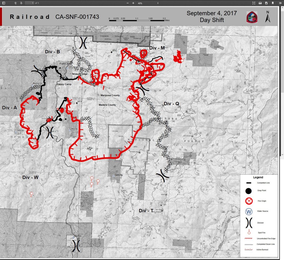
The fire is now estimated at 9,790 acres with 23 percent containment. The number of structures lost has now risen to 14.
Early yesterday evening, a spot fire was reported between Bissett Station Road and Miami Trails. Madera County Sheriff’s deputies located the 10-acre spot on Forest Road 6S17 near 6S24 and flagged it for firefighters.
A strike team of Type 3 engines responded, and just as they were arriving, word came from the incident meteorologist that a wind event was expected in the next 30 minutes, with gusts up to 30 mph. That indeed happened, and by 9:20 p.m., snags were torching, embers flying everywhere and trees where falling. Though crews worked hard to get a hose lay around the fire, by 10:03 p.m. everyone was ordered to pull out and regroup as the winds picked up and the danger increased.
Dozers were sent in to cut a line two blades wide along the southern perimeter of the now-15-acre fire. Deputies started well before dawn going door to door along Road 620 (Bissett Station) to Road 628, warning residents to be prepared to evacuate if necessary.
Last night, crews started near Sugar Pine and were able to successfully burn off the dozer line on the east side and walk it down to the 6S90 road. They reportedly had that line checked up just before the day shift came on.
The fire made a push on the bottom into the south fork of Lewis Creek, and is reported to be holding in the creek this morning.
Up near Calvin Crest, the fire worked its way around the west side and across the top. Firefighters protected those points all through the night. There is still a lot of work to do as the fire makes its way toward the burn from the Sky Fire in 2015. That fire was stopped right at the road into Calvin Crest, and at the southern boundary of Camp Redwood. Both are undamaged as of this morning.
Just north of Cedar Valley, crews cut in a dozer line three blades wide across the top and down the side east of Manzanita Drive. That line runs all the way out to Highway 41. While significant wind events were taking place higher up, the influence of those winds didn’t reach down into the bowl and cause problems for firefighters.
Everything seems to be holding well along the west flank of the fire from Miami Mountain up to Fish Camp and across to the Tenaya Lodge. Also, lines continue to hold near the ignition point, in the interior near the Yosemite Mountain Sugar Pine Railroad.
Crews continue to work on spot fires and strengthening lines up on the northeast corner. There is one large spot fire just southwest of Harts Meadow.
Dozers have cut indirect line from Big Sandy south to just west of Soquel Meadow.
 A look at the perimeter map (see below) shows that the fire has pushed well in Nelder Grove, and is approaching the campground and the two historic cabins. Those cabins have been wrapped with fire protective material, and should withstand the flames.
The fire area continues to be under a moist air mass from the remnants of tropical storm Lidia. Unstable atmosphere and daytime heating means a good chance of thunderstorms and more outflow winds, and possibly lightning. There is even a 20 percent chance of some wetting rain.
Temperatures will be in the mid 80s at 5,000 feet, and in the mid 90s at Base Camp. Relative humidity is expected between 25 and 35 percent.
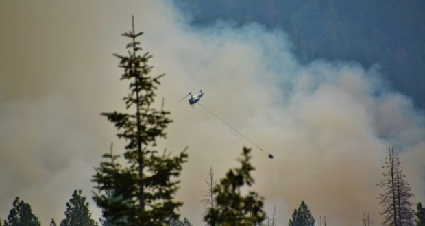
There are currently 800 personnel assigned to the incident including 89 engines, 13 hand crews, 5 helicopters, 12 dozers, and air tankers as available.
Closures and evacuations on the Railroad Fire (in addition to Sky Ranch):
A mandatory evacuation order has been issued for the Cedar Valley Subdivision, including the following roads:
- Cedar Valley Drive
- Deer Run Trail
- Lazy Oak Drive
- Cedar Brook Road
- Cedar Springs Road
- Mountain Meadow Road
- Chu Ranch Road
- Tolladay Road
- Jackson Road
- Cedar Ridge Circle North and South
- ManzanitA Drive
- Three Springs Road
- Lakeside Drive
- Cedar Place
Highway 41 remains closed in both directions from Cedar Valley on the south (about three miles north of Oakhurst), to Wawona inside Yosemite National Park. Yosemite visitors should use Highway 49 to Highway 140 or 120 for entrance to the National Park.
Road closures include all Highway 41 offshoots between Cedar Valley Road and Summerdale Campground north of Fish Camp, in both Madera County and Mariposa County, and Road 630 (Sugar Pine Road) and all cross streets, including Sugar Pine Christian Camps.
Jackson Road (6S07) is closed from Fish Camp to Beasore Road.
A mandatory evacuation is in place for the the community of Fish Camp, the Tenaya Lodge, the Narrow Gauge Inn, the Yosemite Mountain Sugar Pine Railroad, the community of Sugar Pine including the Christian Camp, Cedar Valley, Sky Ranch, Big Sandy and Summerdale campgrounds, Nelder Grove, Camp Redwood, Paradise Springs, Calvin Crest, ECCO Conference Center, and Soquel and Texas Flat campgrounds.
Road 620 (Bissett Station) has been given an evacuation advisory due to the spot fire just north toward Miami Motorcycle Trails.
There have been some changes to this list of Forest road closures:
- Road 632
- Forest Road 5S10 at 5S39
- Forest Road 6S13 at Road 274
- Forest Road 6S08 at 6S36
- Forest Road 6S10 at 6S39
- Forest Road 6S99 at Beasore Road
- Forest Road 6S40 at Beasore Road
- Forest Road 6S40X at Beasore Road
- Forest Road 5S40Y at Beasore Road
- Worman Road one mile in from Highway 49 (at Road 601).
The community of Wawona is still on alert to the possible threat from this fire. Residents and visitors are encouraged to make appropriate pre-evacuation preparations.
The Red Cross Evacuation Center at the Oakhurst Community Center has been reopened at 39880 Road 425B.
Also, the Central California Animal Disaster Team (CCADT) has re-activated a small animal shelter at the Oakhurst Community Center Pavillion Building. Large animals can be sheltered at the Coarsegold Rodeo Grounds, at 44777 Rodeo Grounds Lane in Coarsegold. The phone number is 559-676-7864.
For animal evacuations, people will need to call the Sheriff’s Office Dispatch at (559) 675-7770 to request help. CCADT will be working with Madera County Animal Control to help with evacs if needed
The hot line number for the Red Cross is 559-343-2549.
All roads past Wawona inside Yosemite are open, except Glacier Point Road, which was closed last Sunday due to increased fire activity on the Empire Fire.
For fire updates, residents and visitors can message RAILROADFIRE (one word) to 888777.
A fire information line has been established for the Railroad Fire at 559-373-0040.
The Railroad Fire was reported at 12:20 p.m. on Tuesday, Aug. 29, just south of the Yosemite Mountain Sugar Pine Railroad on the west side of Highway 41. It is burning on the Bass Lake Ranger District of the Sierra National Forest.
The cause of the fire is under investigation.