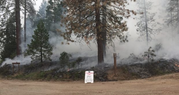
PRATHER – Residents in Eastern Madera County may see smoke from prescribed burning over the next few months as the High Sierra Ranger District implements their fall/winter prescribed burn program, set to be completed before the end of the year as cooler weather and moisture arrives across the area.
Fire activity throughout the state and across the country has moderated, and Sierra National Forest (SNF) fire crews have returned from fires outside the area and are becoming available to support and manage SNF prescribed fire projects.
Fire managers on the High Sierra Ranger District are planning ignitions for 600 acres in several units for the Dinkey South prescribed burn. This understory burning will begin in the month of October and last through early December. Taking advantage of favorable weather conditions, ignitions will begin where they ended last spring.
The acres successfully treated last year for the fall/winter/spring projects on the District included 2,500 acres of pile burning and 1,600 acres of understory for a total of 4,100 treated acres.
“This landscape restoration project takes a proactive approach to reducing vegetation, strengthening protection for local communities from destructive wildfire, and providing for forest resiliency using mechanical and prescribed fire treatments that restore, enhance and sustain a healthy forest ecosystem,” say SNF officials.
Fire personnel and equipment will be committed to the project until the treatment is extinguished as burn days permit. The treatments will be broken up into several units, and it is expected to take one to two weeks to complete ignitions. Expect active burning and visible smoke for several weeks after.
As the decision is made on when to conduct the prescribed burning, more details will be sent out and posted on the SNF website as to where the public can learn more, see pictures, and get maps. If forest closures are necessary, the exact locations will be announced when dates for each ignition are released.
If you are visiting the forest, be aware that fire and smoke will be visible. Signs will be posted to alert visitors and residents to the presence of smoke and fire – along with firefighters and firefighting equipment – along the roadways. The public is asked to please obey all posted speed limits and drive cautiously on forest roads.
All prescribed burns are conducted in coordination with the San Joaquin Valley Air Pollution Control District in order to reduce impacts for both communities and the public by finding weather windows with good smoke dispersion. Local residents and visitors to the forest can learn more about air quality and smoke by visiting either www.airnow.gov or www.valleyair.org.