
MOUNTAIN COMMUNITIES–Check below for weather alerts, road conditions including traffic collisions, closures and hazards, school closures, power outages and other emergencies as they happen.
Related article: Wind, Rain and Snow Returning Today
We will continue to update this article throughout the storm – stay safe!
Monday, January 16th, 2023
School Closures/Delays for 1.17.2023
Madera County
Update for YUSD
Update – 2 hour delay for all YUSD Schools Tuesday, January 17, 2023.
At this time our plan is for all YUSD Schools to be on regular schedule tomorrow, Tuesday, January 17.
Our Transportation Manager will be out early in the morning assessing the roads. If her determination impacts school start times, we will communicate this by 6am.
Thank you for your patience and understanding. Stay safe and warm.
Delay Notice – Tuesday, January 17th, there will be a 2 hour bus delay for North Fork School. School will officially start at 9:57am. Please do not drop your student off any earlier than 9:30am. Thank you
1/16/23 – (This message is for tomorrow) This is Robert Dias, MOT Director for Bass Lake School District informing you that Tuesday, January 17th there will be a two hour bus and class delay for OES, OCI, Wasuma, and Fresno Flats due to weather and road conditions.
Coarsegold K – 8 has a 2 hour delay. School will start at 9:45am.
Good Evening Parents of Students Who Attend and Staff Who Work at North Fork, Spring Valley, Mountain Oaks, Chawanakee Academy, Cedar, Minarets Schools and the District Office,
On Tuesday, January 17, 2023, no students are to report to campus until 1-hour LATER than the normal school start time, as there will not be student supervision.
Chawanakee Bus Routes 1, 2, and 3 will run on a 2-hour delay due to road conditions and safety.
Staff are expected to report on a 1-hour delay, (e.g., 1-hour LATER than their normal report time) unless otherwise communicated to their supervisor. Any staff whose normal report time is between 5 – 8 am are expected to report 1-hour LATER than their normal time.
Clarification for Tuesday, 1-17-23
Chawanakee Community,
NEW INFORMATION:
Due to road conditions and safety, there will be a 1-hour delay for students who ride bus routes 4, 5, 7, 8 and 9 on Tuesday, 1/17/23.
School starts for Hillside students at the normal time.
NO CHANGES TO THE FOLLOWING PREVIOUSLY COMMUNICATED INFORMATION:
Students who ride bus routes 1, 2, and 3 are on a 2-hour delay, Tuesday, 1/17/23.
School starts at North Fork, Spring Valley, Mountain Oaks, Minarets, Minarets Charter, Cedar, and Chawanakee Academy 2 hours LATER than normal (e.g., Minarets/Minarets Charter HS starts.
Mariposa County
Due to icy conditions, SFCS will observe a 2-hour delay tomorrow, Tuesday, January 17th. School will start at 10:25AM. The bus will run exactly two hours later than the regular morning schedule. Safe travels, everyone!
Due to road conditions/road closures, MCUSD will have a 2 hour delay 1/17/23
Ahwahnee
Type: Traffic Hazard
Location: Thunderhead Dr / Sr49
Loc Desc: Lat/Lon: 37.406168 -119.734193
Multiple vehicles pulled over installing chains
Coarsegold
Type: Provide Traffic Control
Location: 43714 Road 415
Loc Desc: Lat/Lon: 37.235464 -119.741962
A tow truck is removing a disabled vehicle
Fish Camp
Type: Trfc Collision-No Inj
Location: Sr41 / Miami Motorcycle Trl
Loc Desc: 41 AT SUMMIT Lat/Lon: 37.444828 -119.653188
Ahwahnee
Type: SPINOUT
Location: Sr49 / Thunderhead Dr
Loc Desc: Lat/Lon: 37.406168 -119.734193
Mariposa County
Type: Mud/Dirt/Rock
Location: Sr140 / Guadalupe Fire Rd
Loc Desc: Lat/Lon: 37.477183 -120.057069
Reportedly blocking both lanes
Oakhurst
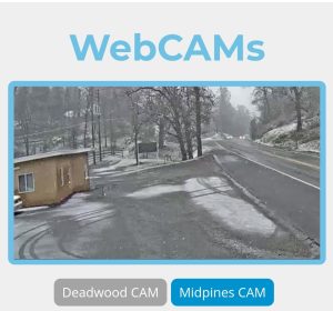
Deadwood Webcam 9:15am
Ponderosa Basin Mariposa County
Type: Trfc Collision-No Inj
Location: Pilot Peak Rd / Creel Rd
Loc Desc: Lat/Lon: 37.465431 -119.735681
VEHICLE INTO POWER POLE
Madera County
Type: Roadway Flooding
Location: Road 207 / Sr41
Loc Desc: Lat/Lon: 37.151344 -119.731556
Mariposa County
Coarsegold
Type: Mud/Dirt/Rock
Location: Sr41 / Broken Bit
Loc Desc: SB 1 MI JNO Lat/Lon: 37.270456 -119.671248
Covering The whole southbound lane
Sunday, January 15th, 2023
Madera County
Type: Trfc Collision-1141 Enrt
Location: 54432 Road 432
Loc Desc: PINES RESORT Lat/Lon: 37.320048 -119.556470
AA traffic collision has occurred. Injuries are unknown at this time and some lane blockage is being reported. A tow truck and ambulance are enroute.
Mariposa County
Update
Hwy 140 is now closed outside of Mariposa at the top of the Briceburg Grade where the turn off is for the Bug Hostel. It is closed all the way to El Portal with no estimated time of reopening.
Mariposa County
Type: Mud/Dirt/Rock
Location: Sr140 / Briceburg
Loc Desc: SR140 / BRICE Lat/Lon: 37.605047 -119.965633
ROCK IN THE RDWY
Yosemite National Park
SUNDAY 1/15/2023 !!ALERT!!
Due to heavy snowfall Badger Pass Rd will remain closed. BADGER PASS CLOSED SUNDAY 1/15/2023!
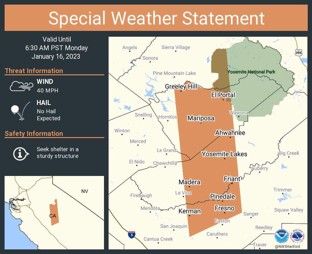
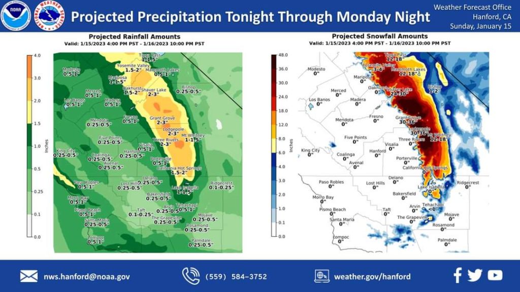
Another storm system will impact Central California tonight through Monday night, resulting in rain in the San Joaquin Valley and snow in the Sierra Nevada. Snow levels will start at around 4,000 feet tonight, before rising to about 5,000 feet Monday. Snow levels will drop to around 3,500 feet Monday night. The majority of this precipitation will fall Monday.
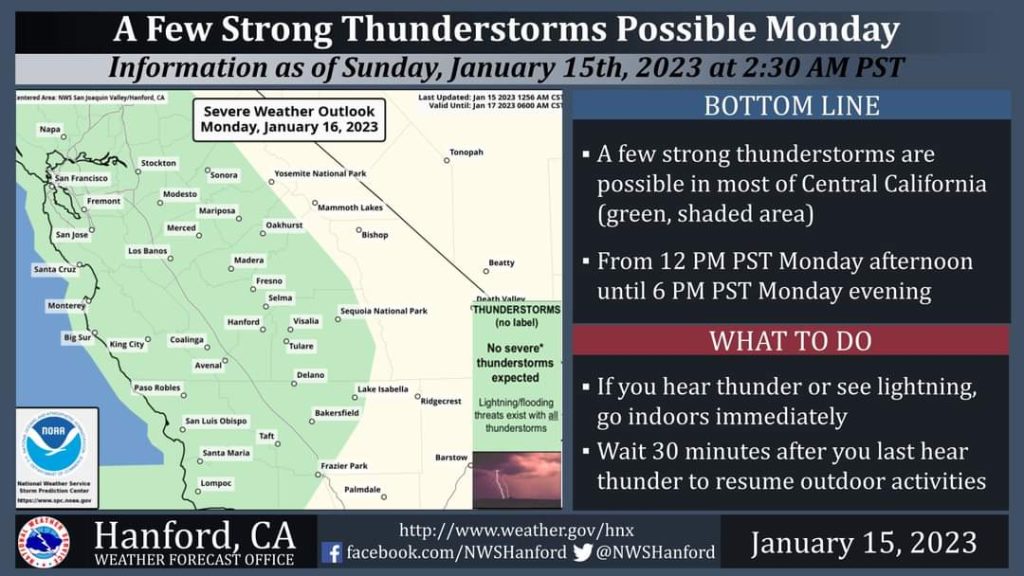
A few strong thunderstorms are possible in most of Central California from 12 PM PST Monday afternoon until 6 PM PST Monday evening. Small hail and wind gusts near 45 miles per hour are a couple of hazards associated with strong thunderstorms. In addition to dangerous cloud to ground lightning strikes, any thunderstorm can produce intense rainfall rates, leading to localized flooding.
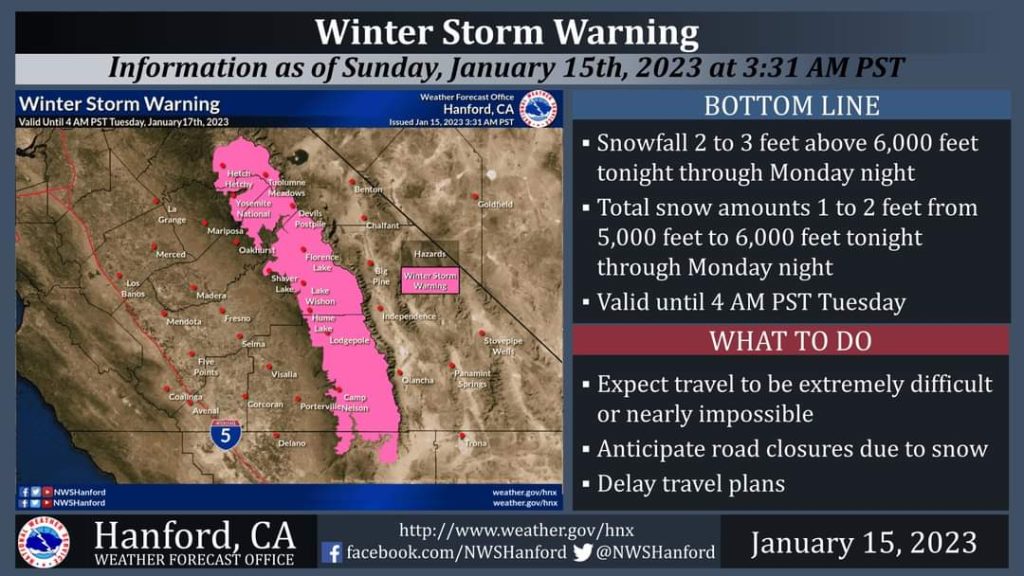
A Winter Storm Warning is in effect for the Sierra Nevada until 4 AM PST Tuesday. The majority of this snow will fall Monday. Travel will be extremely difficult or impossible. If you plan to travel, consider alternate strategies. If you must travel, remember to carry tire chains, plenty of food, a good deal of water, warm clothing, and a flashlight in your vehicle.
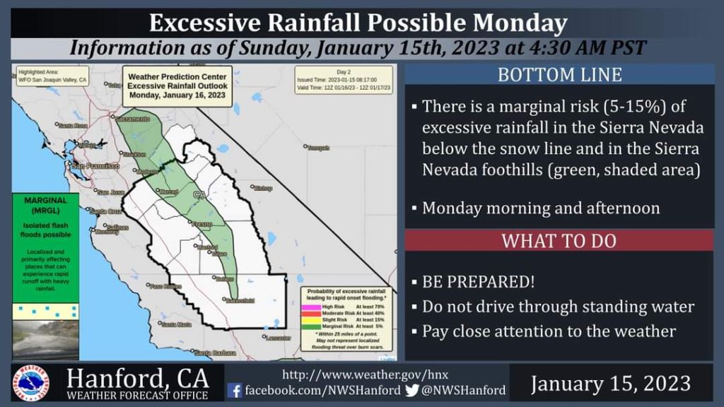
There is a marginal risk of excessive rainfall in the Sierra Nevada below the snow line and in the Sierra Nevada foothills Monday morning and Monday afternoon. Rockslides, mudslides, and debris flow flooding are possible.
Saturday, January 14th, 2023
Mariposa County
Type: Mud/Dirt/Rock
Location: Sr140 / Briceburg
Loc Desc: WB JWO Lat/Lon: 37.605047 -119.965633
Indian Lake Estates
Type: Roadway Flooding
Location: Seminole Ave / Delaware Rd
Loc Desc: Lat/Lon: 37.209208 -119.677900
RDWY HAS COLLAPSED
North Fork
Type: Traffic Hazard
Location: Road 200 / Mountain View Peak Rd
Loc Desc: JWO Lat/Lon: 37.184832 -119.623859
LRG TREE/ WILL NEED CHAIN Saw NEAR THE 200 BRIDGE PROJECT
Coarsegold
Type: Traffic Hazard
Location: Sr41 / Road 415
Loc Desc: NB JSO Lat/Lon: 37.261194 -119.701446
NO DETAILS

