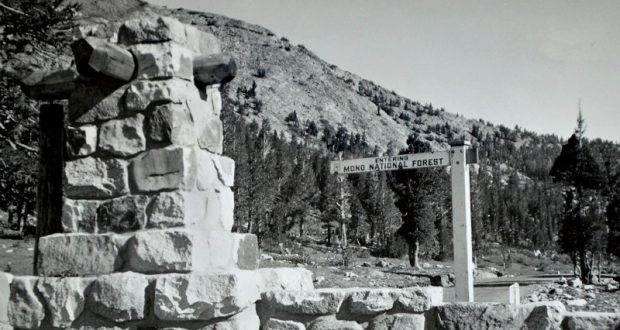
The Mono Museum in North Fork would like more information about the site in this photograph. It is at the edge of the Mono National Forest in Mono County. What is significant about this place? Any information will be appreciated.
Have you visited the refurbished Mono Museum in North Fork? It is open Monday, Wednesday, Friday, & Saturday from 10 a.m. – 2 p.m., except holidays.
Please scroll down to the comments section to read the posted comments, and/or post your own.
UPDATE:
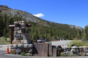
“This photo was taken on June 16, 2021, at Tioga Pass from nearly the same angle as the photograph of the Mono National Forest sign from circa 1945. Note the skyline ridge in the background. The exact site of the post for the sign is now buried under the shoulder pavement on the far side of the granite wall.”
Follow-Up to History Mystery #98
I would like to take this opportunity to thank everyone that posted to this month’s History Mystery.
We have some maps from the California State Railroad Museum, but we never checked with the Perris folks. I didn’t know they had a collection of SP track maps and structures. Thank you so much for that info. We will contact them, I didn’t know they changed their name from the Orange Empire Railway Museum.
The roadbed right up to the Raymond Museum is still quite intact and visible. Once you pass the museum, it was all bulldozed in the 1940s so they could race horses in that area. But, we have a really good idea now where things were. We already knew where the turntable was located. It isn’t exactly where everyone thinks it was.
Last weekend we surveyed and located all the track from the caboose to the depot location. We know where the turntable lead and switch were located, we located the switch for the Sleeper car track, located the sleeper car track, and several structures. The ground was extremely dry and hard, so our stakes probably won’t stand in the wind. But we have a great start and will continue once we have permission from all the property owners.
Thank you, everyone, for your interest in our project, and for your contributions. Feel free to stop by and visit if you see us working out there. We’re the guys in red shirts.
Dan Carrion
ECV Grub Gulch 41-49 Chapter


The photograph of History Mystery #99 is taken from what is today Highway 120 at Tioga Pass in Yosemite National Park. It is looking east down the Tioga Road into what today is the Mono Ranger District of the Inyo National Forest. Wikipedia indicates that the Mono National Forest was “…established on May 25, 1907. On July 1, 1945 land from the former Mono National Forest was added.” This would mean that this photograph was probably taken prior to 1945. If you go to Tioga Pass in Yosemite National Park on Google Maps, and then go to Street View, you can swivel the view to see the entrance stone work of the granite wall in front of the sign. The skyline to the left of the photo hides the Gaylor Lakes and historic mines of Bennettville. Enjoy! MJO
Comments from SNO Facebook as 6-5-21:
Bryant Platt
Looks like Tioga Pass?
Joe Meyer
Yes, looking northeasterly from the Tioga Pass gate, entrance kiosk and cabin would be on the left of this photo.
Top Fan
Mellie Bradley
Bryant that was my first thought too!
Joe Meyer
https://en.wikipedia.org/wiki/Mono_National_Forest…
Mono National Forest – Wikipedia
EN.WIKIPEDIA.ORG
Mono National Forest – Wikipedia
Mono National Forest – Wikipedia
Steven M. Bumgardner
There is no Mono Natl Forest. Perhaps they mean Inyo.
Joe Meyer
Steven M. Bumgardner there used to be.
Tom Atkeson
Steven M. Bumgardner Mono National Forest was established by the U.S. Forest Service in California and Nevada on July 1, 1908 with 659,456 acres (2,668.72 km2), almost all in California, from parts of Inyo, Toiyabe, Stanislaus and Sierra National Forests. On July 1, 1945 the entire forest was divided between Inyo and Toiyabe and the name was discontinued.
Top Fan
Mellie Bradley
Tioga Pass gate facing east heading out of Yosemite NP into National Forest. The stone gate with logs sticking out on right side of photo, and the rocky granite slope on left side of road look like they match historic photo.
May be an image of tree, road and text