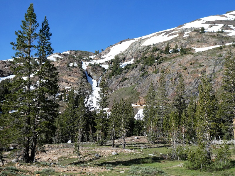
Are you up for an easy hike to the old mining town of Bennettville? How could I not ponder what it must have been like back in 1882 when a new town with a population of 50,000 was envisioned and that they would be striking it rich as soon as they hit “The Great Silver Belt?” They worked and lived in beautiful country, filled with reflective high lakes and snow capped mountains.
Where: Inyo National Forest
Distance: About 1.5 Miles Roundtrip
Difficulty: Easy
Elevation Range: 9,557′ – 9,640′
Date: July 17, 2019
Maps: Falls Ridge and June Lake Topographic Quads
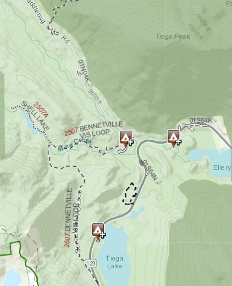
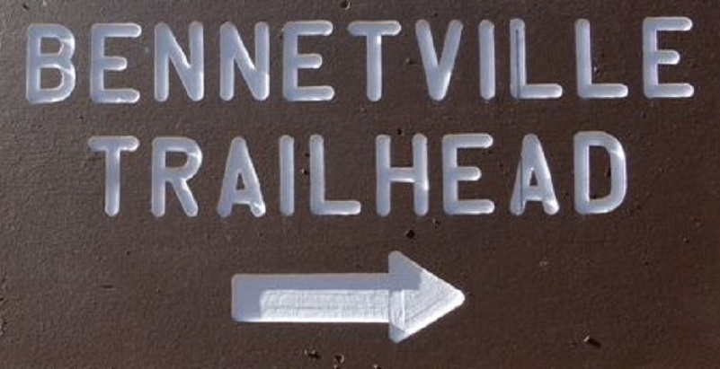 This is a hike that doesn’t take all day and can be a great stretch your legs stop as you drive over Tioga Road. There are two possible start points for the hike to Bennettville and the Great Sierra Mine. One is at a wide pullout across from Tioga Lake, just east of the Yosemite National Park entrance station at Tioga Pass. The other trailhead starts at the Junction Campground in the Inyo National Forest at the intersection of Hwy 120 and Saddlebag Lake Road. It just happens that is where I had camped so we had an easy journey to the trailhead that starts at the Camp Host’s campsite in the campground. If you are not camped, you can park in the parking area before the bridge, jus before you enter the campground where a E. Clampus Vitus historical marker and old piece of mining equipment stand. Sally and I headed up the trail to the old mining town of Bennettville.
The trail is fairly easy, except there are a few spots where you need to navigate up and down through short rocky sections. Hiking poles or a steady hiking buddy can make this part easier. We also passed over 3 small seasonal creeks with the help of a few strategically placed rocks. These little creeks are only about 6 inches wide and dry up later in the summer. If you are watching where your feet are stepping, you may miss the first site that you have of Bennettville because it sneaks up on you.
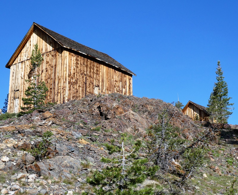
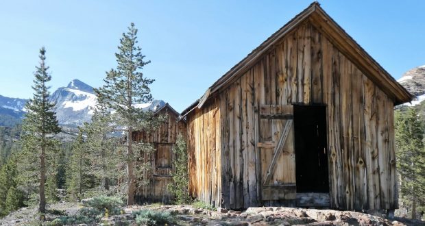
The old mining town of Bennettville housed those hardy miners when 14 buildings stood but time has been reclaiming the old town. The place was first named Bennett City, then the name of Bennettville took over, named after Thomas Bennett, President of the Great Sierra Consolidated Silver Company. The United States Forest Service restored two of the buildings, an assay office and a bunkhouse, back in 1993. As I walked around the buildings, I could spot old rock foundations of buildings long gone.

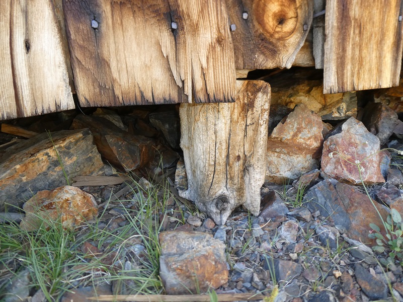
Visitors have found old treasures from the past and placed them for people to see them. Old pieces of bottles and metal pieces always have me wondering what purpose they had served and what were the miners like who lived up here?

From Bennettville, I could look over to the Great Sierra Mine. It’s tailings are visible through the trees and you can walk over to it fairly easily by following the trail past Bennettville, taking the fork in the trail down to the creek and crossing some logs to get over to the side. You can also cross a little higher upstream and catch the old road that goes up to the mine. The entry to the mine is gated off inside the mine but there is still mining equipment adjacent to the entry that you can check out. I didn’t visit the mine this trip though.
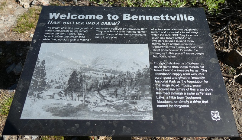
To understand how important Bennettville was to the mining history in this area, I need to tell you a bit of history. There was an old mining area referred to as Tioga Hill, located about one mile northwest of Tioga Pass on the eastern boundary of Yosemite National Park. A band of white quartz runs along its crest and is known as “The Great Silver Belt.” This is the setting for the mining boom in the 1870s and 1880s that occurred in the area of Dana City.
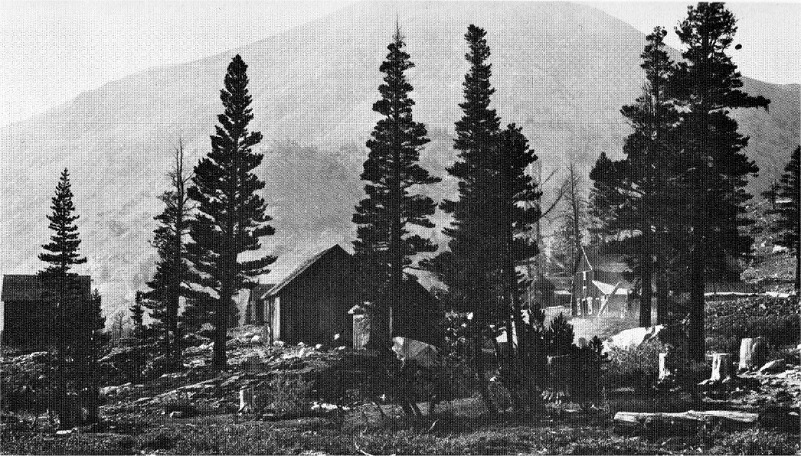
Bennettville, about 1898 (Photo Courtesy Yosemite Museum, National Park Service)
Information for this story comes from the 1958 book Ghost Mines of Yosemite by Douglass Hubbard. This is how the area got its mining start.
1860:
A prospecting party consisting of a justice of the peace, an ex-sea captain, a surveyor, a dentist and a professor were prospecting in the Bloody Canyon area. The dentist, George W. “Doc” Chase, remarked, while camped near Tioga Pass, that if they could but spend one more day in the area he could locate and claim ‘the biggest silver ledge ever discovered.’ The next day he placed a flattened tin can, on which he scratched the location notice with his knife, on Tioga Hill. The ore he carried out was never assayed as he and his partners arrived at Monoville just when the Aurora strike was made. Each made money but none ever returned to the ‘thundering big silver ledge’ on Tioga Hill.
1875:
William Brusky, Jr. was herding his father’s sheep and he found a rusty pick and shovel and a flattened tin can, on which he could make out, “Notice, we the undersigned” and the date 1860. Having heard of the lost mine, Brusky took ore samples to his father, who tested them and pronounced them worthless. The next summer he ‘sank a small hole in the ledge and procured some better looking ore.’ It was not until 1877 that an assay found the ore to be rich in silver.”
1878:
9 claims were made in the area and the Tioga Mining District was organized.
1880:
Dana City, the site of the Great Sierra Mine, was given a Post Office.
1881:
William H. Brusky died. The Great Sierra Consolidated Silver Company bought up all of the claims on Tioga Hill. No pay dirt was hit so they regrouped.
1882:
Work started in the Great Sierra Tunnel. Their plan was to dig a tunnel 1,784′ down where they hoped to hit that big silver ledge. That year, the new town of Bennettville got its own Post Office. More than 350 claims had been made in the Tioga Mining District by this time.
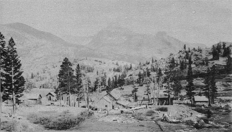
MOUNT DANA LOOKS DOWN ON BENNETTVILLE, FROM A PHOTOGRAPH TAKEN IN 1898 (Ghost Mines of Yosemite (1958) by Douglass Hubbard)
The local newspaper at the time was over at Lundy and named the Homer Mining Index, a great resource to read about the happenings of the times in case you would like to read more.
Homer Mining Index February 18, 1882:
The Coming City. Was the next point of interest reached. The embryo town at the mouth of the Great Sierra (commonly called Tioga) tunnel is called Bennett City, in honor of Thomas Bennett, Jr., of New Bedford, Massachusetts, President of the Great Sierra Consolidated Silver Company. It is situated in a beautiful valley or cove, at the base of Tioga Hill, 9,300 feet above sea level, and is sheltered on the south and west by the towering and somber cliffs of Tioga Hill, on the north by the timbered ridge between Slate and Lee Vining creeks and on the east by heavy timber, while Slate creek, a large and beautiful mountain stream, goes rushing and laughing through the center of the vale – under the snow in Winter, through rich verdure in Summer – and a magnificent cscade leaps from a high cliff to the valley a few yards south of the tunnel from May until November, forming a great blue glacier in Winter. Bennett City, being centrally and beautifully situated, will be the principal town of the district, though when the mines are developed they will doubtless support one or tow other town of considerable size. But all of the mines of Tioga Hill as far north as Mount Conness will be tributary to this place, as will also the Rhinedollar group of mines on the eastern line of contact and on both sides of Lee Vining Creek, and all of the mills and other reduction works required by both tiers of mines in the central portion of the district. Bennett City will also be the terminus of the wagon road to be built early in the coming Spring by the Great Sierra Company, to connect the mines with the railroads of the San Joaquin Valley. A portion of the mouth of the tunnel has been located for placer mining and some good prospects obtained, but there is ample room on gently rolling ground for a city of 50,000 inhabitants, with an abundance of wood and water of the best quality on the ground.
Telephone lines soon reached the new townsite of Bennettville, strung from Lundy.
Homer Mining Index March 11, 1882:
The Lundy and Tioga telephone line, recently constructed by the Great Sierra Con. S. Co. of Tioga, is the highest telephone line in the world. The line is about nine miles in length, descends 4,245 feet from Lundy, crosses Mount Warren divide at an elevation of 12,250 feet above sea level, descends 3,750 feet to Lee Vining Creek, and again to Bennett City, which is 9,300 feet above sea level.
With the mining work moving to the from Dana City to the new mine above Bennettville, the old post office at Dana City was rescinded and the application had been made to create a post office at Bennettville. On March 13, 1882, a post office was established at Bennettville. The mail came over a trail from Lundy which was supplied from Bodie, which had daily service from Carson City, Nevada.
Homer Mining Index May 6, 1882:
Mr. John M. Martin has six men at work putting up his Tioga saw mill, situated just below Lake Lee Vining (Ellery Lake), where the stream of that name enters the gorge that separates Mount Warren from the northern wing of Mt. Dana. It is about one mile from Bennettville and the mouth of the Great Sierra tunnel, is almost within a stone’s throw of the Rhindedollar mine. . .
The Homer Mining Index records many exiting times at Bennettville and the surrounding area, too many to share them all here. The mine was worked year round and stories of frostbite, sledding injured men from Bennettville to Lundy and an avalanche are just a few.
Probably one of the most significant improvements from Bennettville was the construction of the Great Sierra Wagon Road. The work on the 56 miles of road was done mostly with Chinese labor. It cost $62,000 and took 100 days to complete. The road went from Bennettville, west to the area of Crocker Station off of Big Oak Flat Road. With the advent of the automobile and the need for roads to drive them on, the National Park Service purchased the Great Sierra Wagon Road in 1915. The road was improved to allow automobiles to travel on it and is now known as the Tioga Road. You can still see portions of the old road as your travel the area. Across from the upper end of Tioga Lake and across the road, there is a portion of the old road that you can walk on and even arrive at the Great Sierra Mine and Bennettville. I highly recommend that you give this pretty easy walk a try.
There was even talk of putting in a railroad. The plan was to tie it in with The California and Yosemite Short Line Railroad Company’s line from Modesto.
Homer Mining Index July 22, 1882:
It is not yet definitely settled whether the road will pass north or south of Mono Lake; but it is known it will run through Tioga Meadows, descend the Tuolumne River to Brooks Pass, four miles northwest of Cathedral Peak, and then cross through a low meadow to Lake Tenaya, which flows into the Merced River. It will follow a glacial canyon direct to Mt. Watkins, near the northern wall of Yosemite Valley, and skirt the wall to the head of Yosemite Fall, where it will ascend Yosemite Creek a short distance in order to reach the elevated plateau to the northwest.
The Great Sierra Mining Company worked a 1,784′ deep tunnel in search of silver. Unfortunately the company ran into financial problems and shut down July 3, 1884. The post office closed in November of that year. Although more than $300,000 had been spent on the tunnel and $56,000 on the road, They hadn’t struck any ore yet but it was “confidently predicted” that the tunnel would cut into the Sheepherder lode “within a few weeks.” There are several attempts over the years to rework the mine but no ore of value was located in these small attempts.

From Bennettville, you can continue up the trail to check out some beautiful small lakes, make a loop over to the mine then back down the old section of the Great Sierra Wagon Road, walking along Hwy 120 by the Tioga Pass Resort and back to your car, or just come back down the way you hiked in. It is all good!
There is a wonderful book at Bennettville that I cannot recommend enough if you want to learn more about Bennettville and the surrounding area. It is called Bennettville and the Tioga Mining District by Alan H. Patera. He includes many stories about the people who lived here, along with historical information. You will probably have a challenge finding it but you can usually pick up a copy on EBay if you set a search.
Dog Hike?
I checked out Sally’s feet during this hike and after we returned to our campsite. That rocky country can be tough on a dogs feet and I brought Sally’s boots with me but she didn’t need them.
This hike can be a good dog hike if your dog is up to it. The rocky terrain is very rough on a dog’s feet and I packed Sally’s boots just in case she got a sore spot on her paw or sliced her foot on one of those sharp rocks. Even if you think your dog’s feet are toughened up enough for this hike, you can have surprises so please be prepared. Sally hiked for 3 1/2 days on this trip. There aren’t any rattlesnakes or poison oak and there is plenty of good, fresh drinking water for her all along the way. That means I don’t have to pack her water and that is a good thing! Sally has never had any problems drinking the water out of these higher elevations but some dogs may not be as easy as Sally on this issue. I think you need to know your dog and you may need to carry some water for them. This area also has bubonic plague and if you dog gets a hold of a critter such as a squirrel or mouse, this could be something to watch for after a trip in this area.
Here is some information from Inyo National Forest regarding their dog rules:
Traditionally, National Forests have welcomed dogs. However there are a few rules that apply to assure that you and other National Forest visitors have an enjoyable outdoor recreation experience. If you are camping with your pet, please practice the following:
- Leave vicious or unusually noisy dogs at home.
- During the day keep your dog on a leash no more than 6 feet long, or otherwise restrict its freedom to roam at will.
- At night keep your dogs and other pets inside an enclosed vehicle or in a tent.
- Developed campgrounds are for people, not animals. Please do not bring more than two dogs or other pet to any one campsite.
General rules for dogs within the Inyo National Forest:
- Dogs are allowed for trips staying in the National Forest. Pet food must be stored the same as required for your food.
- Dogs are prohibited, as are any other pets, on trips visiting the wilderness of Yosemite, Sequoia and Kings Canyon National Parks.
- Pets need to be on leash or under verbal command. Do not allow pets to chase or harass wildlife.
Doarama:
What is a Doarama? It is a video playback of the GPS track overlaid on a 3 dimensional interactive map. If you “grab” the map, you can tilt it or spin it and look at it from different viewing angles. With the rabbit and turtle buttons, you can also speed it up, slow it down or pause it.
Map, and Profile :
Junction Campground Map

Junction Campground to Bennettville Topographic Map

Junction Campground to Bennettville Profile
Prior Blogs in this Area:
Camping & Fishing With Sally in Tioga Pass June 19, 2019
Hiking Through July Snow To Gaylor, Granite Lakes & The Old Mining Town Of Dana City July 1, 2019
Hiking from Tioga Lake to Bennettville and up to Green Treble Lake Loop October 12, 2018
Hiking from Tioga Lake to the Great Sierra Mine and High Lakes Beyond August 10, 2017
Hiking with Sally From Bennettville to Green Treble Lake August 18, 2016
Bennettville to Spuller Lake Snow & Ice Hike February 13, 2013
Hiking With Sally And Raven from Bennettville to Green Treble Lake June 2, 2014
Hiking to the Old Mining Town of Bennettville and the Lakes Beyond November 11, 2014
Bennettville to Spuller Lake Snow & Ice Hike February 13, 2013
Sources:
The Great Sierra Wagon Road Wikipedia
Chinese in the Woods: Logging and Lumbering in the American West By Sue Fawn Chung
Homer Mining Index http://www.lundycanyon.com/the-homer-mining-index/
Hubbard, D. H.,Ghost Mines of Yosemite, 1958, Awani Press, Fresno.
Ghost Mines of Yosemite (1958) by Douglass Hubbard
Trexler, Keith A., The Tioga Road; a History 1883-1961 http://www.yosemite.ca.us/library/tioga_road/mines.html
Patera, Alan, Bennettville and the Tioga Mining District, Western Places, Lake Grove, Oregon, 2003

