My hiking boots took me on an adventure along the Old Coulterville Road, a historic stagecoach route that brought people to the Yosemite Valley starting in 1874. Stage stops along the way provided a change in horses, a break from the bumpy, dusty, cold or hot ride, and maybe some food or a night’s rest. Imagine the stories that came with those early tourists and imagine the anticipation of visiting this much talked about place with high cliffs, gigantic waterfalls and towering Sequoias. I was headed to Little Nellie Falls, not a gigantic waterfall but it is a very pretty, tranquil one just over the Yosemite National Park boundary in Stanislaus National Forest.
Where: Yosemite National Park and a short stretch through Sierra National Forest
Distance: 5.37 Miles
Difficulty: Easy to Moderate
Elevation Range: 4,305′ – 4,816′
Date: April 15, 2021
Maps: CALTOPO: Hiking on the Old Coulterville Road to Little Nellie Falls
Dog Hike? No
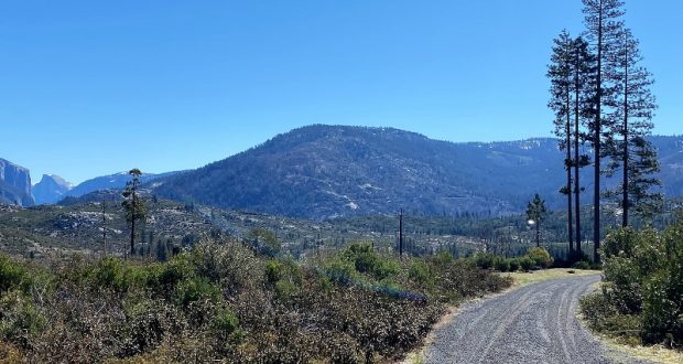
From Hwy 140 in Yosemite Valley, I took Big Oak Flat Road through the 3 tunnels and a little over 4 miles. There was a sign to Foresta on the left hand side of the road where I turned left and drove down to the fork at the Old Big Oak Flat Road where the split rail fences are. I parked so I was off the road and not blocking anyone, then started walking up the road along Big Meadow and two beautiful old barns.
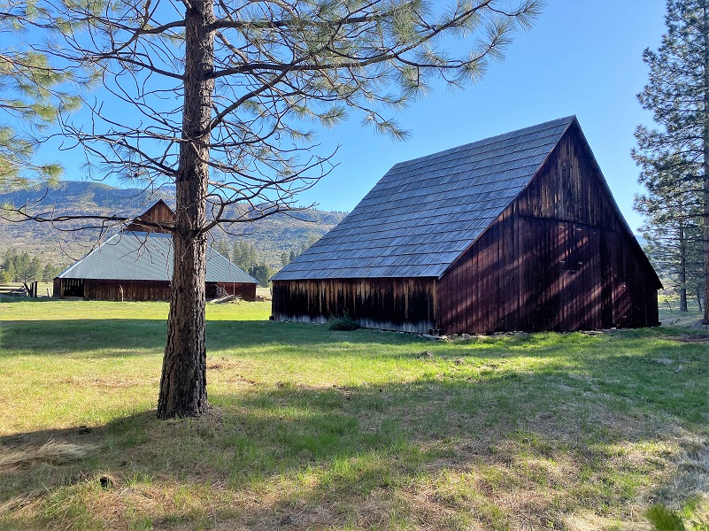
The barns were built by George Meyer, a ship carpenter who immigrated from Germany and took over his brother Henry’s homestead in Big Meadow in the 1870’s. Back then, the meadow was quite a bit smaller than its present size before George cut trees and cleared brush. He built one of the barns in the late 1870’s and the other barn in the early 1880’s. The walls of the latter barn were supposedly built flat on the ground and then raised in one piece. The National Park Service has owned the barns since 1974 and restored them in 1996.
Meyer’s ranch was a stage stop on the Old Coulterville Road and he supplied grains and vegetables to Yosemite Valley businesses. He died in San Francisco in 1917 and was buried there. Of course, I got a little curious about him and decided to do some more snooping. He was born in Aldenburg, Niedersachsen, Germany in April of 1848, census records say that he arrived in the United States 1874 and from the California Voter Registers, he was naturalized in April 27, 1881 in Tuolumne County. Another of George’s brother named John or Johan, born 1830, was living in Groveland in Tuolumne County when he died in 1924.
On April 29, 1901, George married Elizabeth Stewart McCauley in Sacramento. She was born 1866 in Liverpool, England and had arrived in the United States in 1884. It is said that she was a niece of James McCauley, pioneer Yosemite trail builder and innkeeper. They had three children but their first child, a daughter named Hazel Caroline, died of Scarlet Fever when she was just 2 years old. Her parents were unable to attend her funeral because they had the same illness. Hazel is buried in the Yosemite Pioneer Cemetery.
The largest barn measures about 50 feet square, with a hipped roof and the center consists of a 25-foot high saddle-notched log crib that supports the center of the steep roof. The crib was surrounded by stalls for livestock on three sides. The exterior wall is a frame structure covered in vertical board sheathing and the original log roof structure was covered with shingles, but that has replaced by sheet metal.
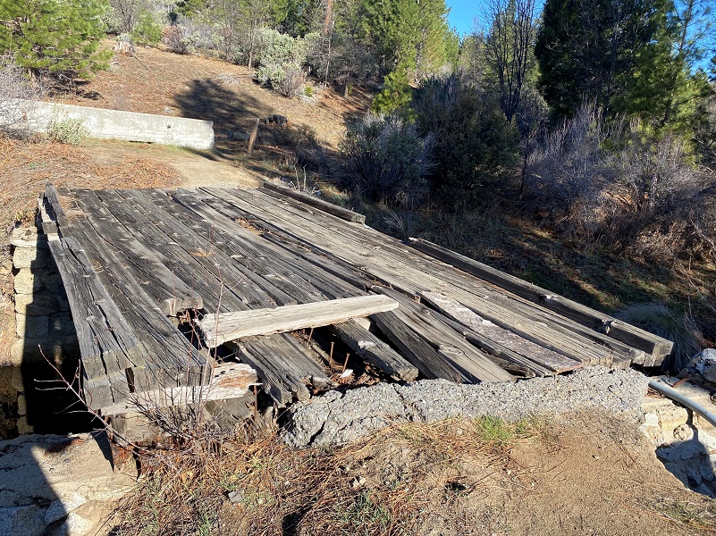
I walked across the old bridge which had been closed to vehicle traffic for some time.
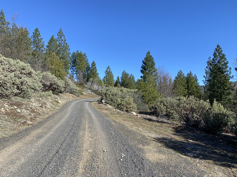
Then I headed up the road which was actually the Old Coulterville Road, with a little rerouting over the years.
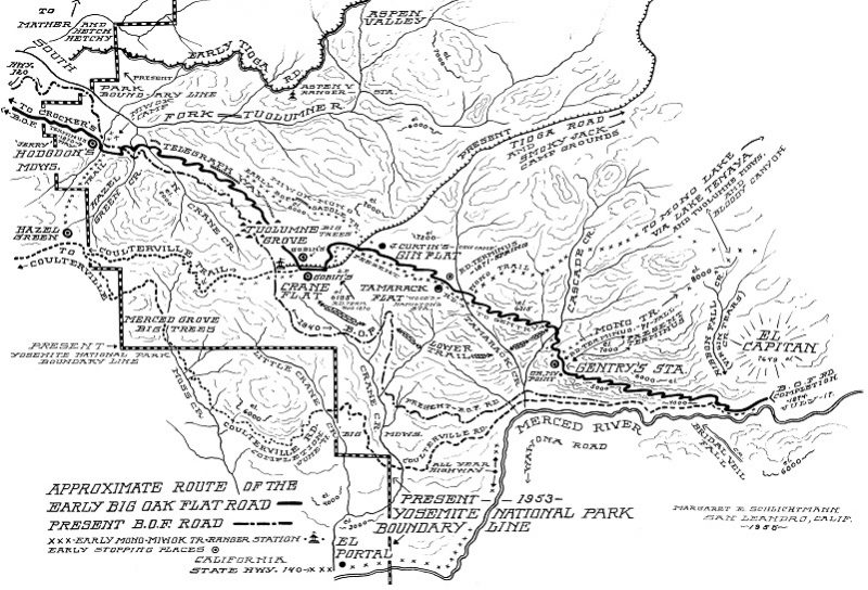
Approximate Route of the Early Big Oak Flat and Coulterville Roads (The Big Oak Flat Road (1955) by Irene D. Paden and Margaret E. Schlichtmann)
The Coulterville Road was the first stagecoach road that reached the Yosemite Valley floor. Before that, the only way to get there was by horse, mule or foot along treacherous trails. In 1870, the Coulterville and Yosemite Turnpike company was organized by Mariposa County citizens that lived on the north side of the Merced River and near Coulterville to build a wagon road from Bower Cave to the western boundary of the Yosemite Valley Grant. Remember, this was long before Yosemite National Park was created.
The road was constructed from Bower Cave to Big Meadow and up to Crane Flat in 1871. But there was competition. A Tuolumne County sponsored a road called known back then as the Big Oak Flat Route, running an additional 5 miles to Gentry’s Station near the top of El Capitan. The 13 miles from Crane Flat or 8 miles from the top of El Capitan were by horseback.
In 1869, the Yosemite Turnpike Company received permission to continue their road down into Yosemite Valley but ran into financial problems. Dr. John McLean took over the Yosemite and Coulterville Turnpike Company and received permission from the Yosemite Commissioners to build and exclusively operate a toll road into Yosemite Valley but a heavy winter in 1872-73 resulted in delays and an extension of the contract. The road was completed on June 18, 1874.
From One Hundred Years in Yosemite by Carl P. Russell:
To Dr. John T. McLean, the president of the Coulterville and Yosemite Turnpike Company, belongs the honor of first making the Yosemite Valley accessible to wheeled vehicles. The Coulterville Company was formed in 1859. It had extended its road to Crane Flat, and, at the insistence of Dr. McLean arranged with the Yosemite commissioners to build and maintain a toll road to the floor of Yosemite Valley. The commissioners had agreed that this company should have exclusive rights on the north side of Yosemite Valley; that is, no other company was to build a road into the valley from the north for a period of ten years. Under this agreement, the Coulterville Road was projected in 1870 and completed to the Merced River in 1874. The following paragraph from a letter sent by Dr. McLean to the president of the Yosemite National Park Commission, 1899, gives interesting information on the discovery1 [ 1 ‘The Walker party, 1833, may have been the first to see the Merced Grove.
While making a survey for this road a grove of big trees was discovered, its existence not having been previously known except to Indians before these explorations for the building of this road were prosecuted. It was determined to carry the road directly through this grove, which was named the Merced Grove by me because of its nearness to the Merced River. In order to carry the proposed road through this new-found grove of Sequoia gigantea it was necessary, in order to secure the best grades and shortest distances to Yosemite, to leave the road already built at Hazel Green instead of at Crane Flat six miles farther east. It was thought the greater length of road required to start from Hazel Green and build through in Merced Grove would be compensated by the advantage the roar would have of passing through this grove of over 50 Sequoias of the way to Yosemite. The additional cost in construction of the road by reason of this new departure from Hazel Green instead of from Crane Flat was about $10,000. The work of construction was vigorously prosecuted, and on June 17, 1874, the Yosemite was first opened to travel by wheeled vehicles over this road, on that day a number of stage coaches and passenger and freight teams passing over it to the level of the valley.
As I walked the old road, how could I not imagine what this stagecoach ride must have been like back in 1874? FYI, the Dudley Ranch was located near Greeley Hill Road and Smith Station Road.
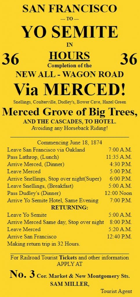
1874 Handbill (Memorable Places)
Here is an interesting article from the Red Bluff Independent dated August 1, 1874 titled “To Yosemite Valley by Carriage.” It describes the sights along the road and advocates opening up Yosemite to “travel on wheels” so more can enjoy.
And if you would still like to read more, here is a link to Yosemite National Park’s Written Historical and Descriptive Data about the Coulterville Road. This document shares that among the famous early travelers of the route were Horace Greeley, Lady Franklin (wife of the ill-fated Arctic explorer), and Ralph Waldo Emerson. There is so much interesting history in this document and here is a snippet:
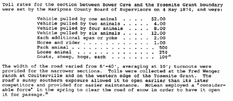
Coulterville Toll Rates (Written Historical and Descriptive Data, Yosemite National Park)
Meanwhile the Big Oak Flat Road was soon completed, reaching the Yosemite Valley floor one month later. So, there were two routes into the valley, one over the top of El Capitan and down into the valley and other from Big Meadow to Crane Flat and then across to the Pohono Bridge in Yosemite Valley.
The routing of the roads has changed since those early days and the old Big Oak Flat route into the valley has had major rockslides on it but you can still hike it, if you are up to some boulder hopping.
The history is really much more complex than my shortened version and the map helps show the different roads back in the day. The Nomination of the Old Coulterville Road and Trail to the National Register of Historic Places back in 1977 provides some wonderful history but there are many other sources that have written about these roads in depth in case you are interested in learning more. A link to that nomination is under the sources at the end of the blog.
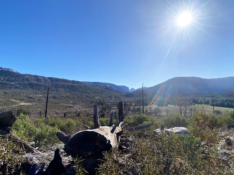
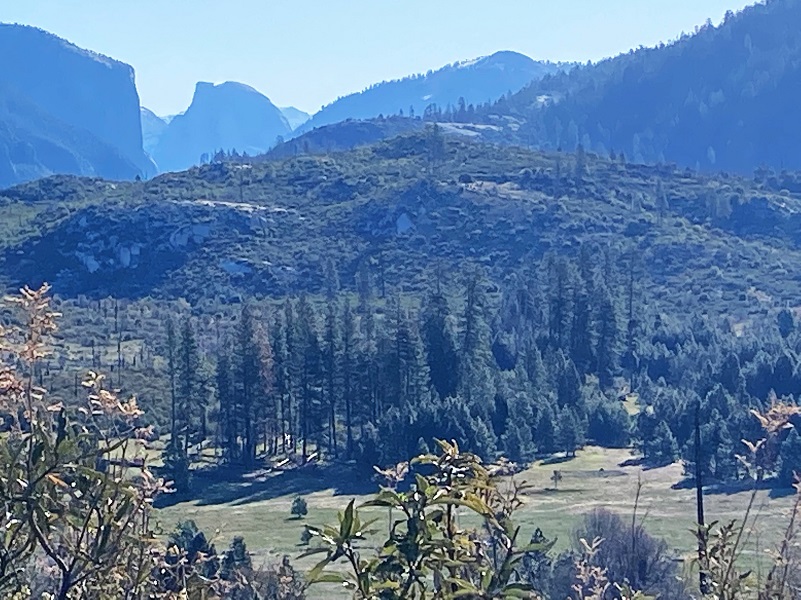
Back in 1990, I was working as a Battalion Chief for CAL FIRE (then CDF) when I was assigned with a strike team to the lightening caused A-Rock Fire that burned through Foresta. That fire ended up burning 17,700 acres and 45 structures before it was controlled. That was over 30 years ago and it was nice to see the many Ponderosa Pines doing well in the burned area. As the road gained elevation, I caught some nice distant views of Half Dome.
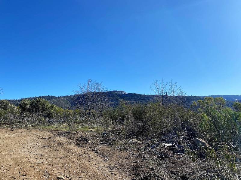
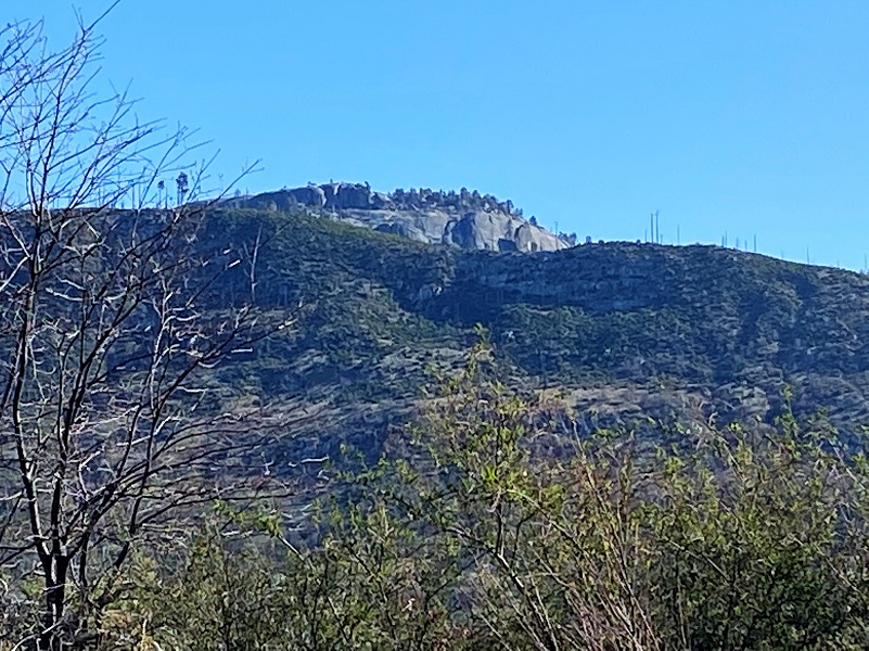
And nice views of Devil’s Dance Floor.
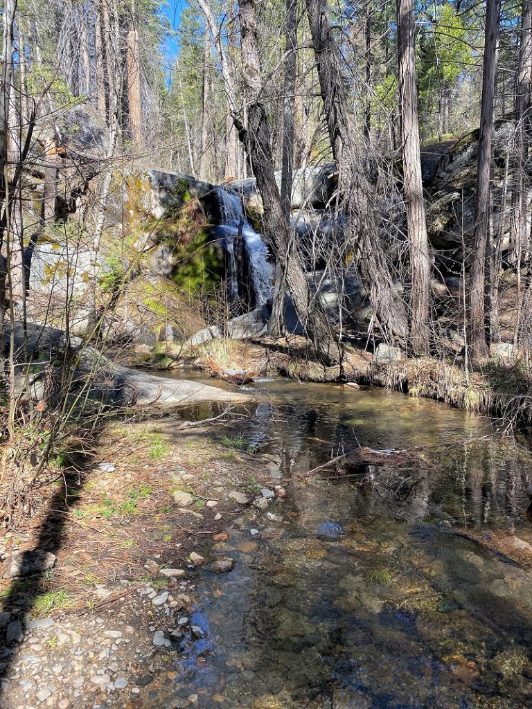
I continued on the main road but be advised that there are a few forks in the road along the way that you don’t want to take. I soon reached Little Nellie Falls. It isn’t a large set of falls, only about 30 feet high and Little Crane Creek was flowing enough water to flow over the road. There is a picnic bench where you can enjoy a break while you listen to the waterfall sounds.

How about a short video of this beautiful little falls?
I headed back the same way I came in and those views of Half Dome and Big Meadow just never get old. Imagine how those passengers on the stagecoach felt as they caught a glimpse of this out their window. They would know that they would soon reach the stage stop where they could get out of their dusty, bumpy coach and stretch their legs.

This is a short hike and nice to combine with Foresta Falls for the day. You can find a link to my blog with both falls at the end but if you stay tuned to next week’s blog, I will cover Foresta Falls with a little more history thrown in. These hikes are good on a cooler day because in the summer it can get rather warm in these shade free areas.
Dog Hike? No
Dogs are not allowed on the Old Coulterville Road within Yosemite National Park, which is where the majority of our hike took place but they are allowed on the USFS section within the hike.
Where Pets Are Not Allowed in Yosemite National Park
- On trails, including the trail to Vernal Fall (however, pets are allowed on the Wawona Meadow Loop)
- On unplowed roads covered in snow
- In undeveloped and wilderness areas
- In public buildings
- On shuttle buses
- In lodging areas
- In all walk-in and group campgrounds/campsites, including Camp 4
- In any other areas, as signed
These regulations protect both pets and wildlife from disease and each other. The National Park Service has prohibited pets on trails for many years. In particular, some pets chase wildlife, pollute water sources, and can become defensive and dangerous in unfamiliar surroundings. Pet owners have the burden to assure their pet does not damage the park values for others in those areas where pets are allowed.
Doarama:
What is a Doarama? It is a video playback of the GPS track overlaid on a 3 dimensional interactive map. If you “grab” the map, you can tilt it or spin it and look at it from different viewing angles. With the rabbit and turtle buttons, you can also speed it up, slow it down or pause it.
Hiking on the Old Coulterville Wagon Road to Little Nellie Falls Doarama
Maps and Profiles:
CALTOPO has some free options for mapping and here is a link to my hike this week overlayed on the 1883 Topographic Map: CALTOPO: Hiking on the Old Coulterville Road to Little Nellie Falls
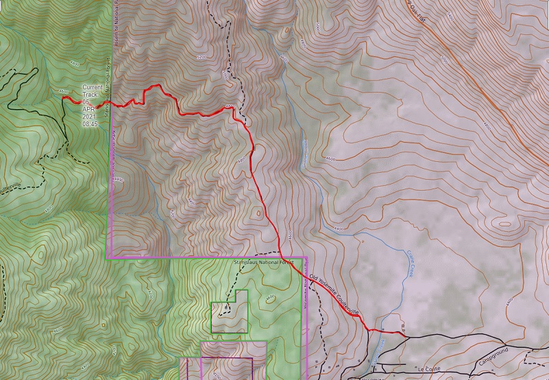
Hiking on the Old Coulterville Wagon Road to Little Nellie Falls Topographic Map
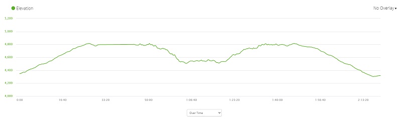
Hiking on the Old Coulterville Wagon Road to Little Nellie Falls Profile
Sources:
1900 Census; Township 5, Mariposa, California; Roll: 93; Page: 10B; Enumeration District: 0038; FHL microfilm: 1240093
Film Number 1302106, California, Marriages, 1850-1945. Salt Lake City, Utah: FamilySearch, 2013.
McCauley and Meyer Barns Wikipedia
McCauley and Meyer Barns National Registry of Places
McCauley and Meyer Barns National Registry of Historic Places Nominee Form
Red Bluff Independent, Volume 14, Number 55, 1 August 1874 — To Yosemite Valley by Carriage
Coulterville Road Written Historic and Descritive Data by Yosemite National Park
Hazel Caroline Myer Find a Grave
The Big Oak Flat Road (1955) by Irene D. Paden and Margaret E. Schlichtmann
Old Coulterville Road and Trail Nomination to National Register of Historic Places
Little Nellie Falls Yosemite National Park
Old Coulterville Road leads to Little Nellie Falls Sierra Star
The Old Coulterville Trail Auto Ramblings
Browning, Peter; Yosemite Place Names, Great West Books, Lafayette, California, 1988
Prior Blogs in the Area:
Hiking to Little Nellie and Foresta Falls January 17, 2018
Hiking Along the Old Big Flat Road December 7, 2015
Hiking To Merced Grove and Beyond On The Old Coulterville Road November 6, 2017


Candice Gregory is doing a great job of informing us about the local trails in the Mariposa and Madera County Sierra Nevada mountains. We’ve done several of the same hikes and her information is right on and very helpful for other hikers. Thanks Candice!
Wow, thank you so much WorldRoutes!