YOSEMITE — The community of Wawona gathered last night to hear from fire officials and law enforcement about suppression efforts and evacuation plans for the South Fork Fire.
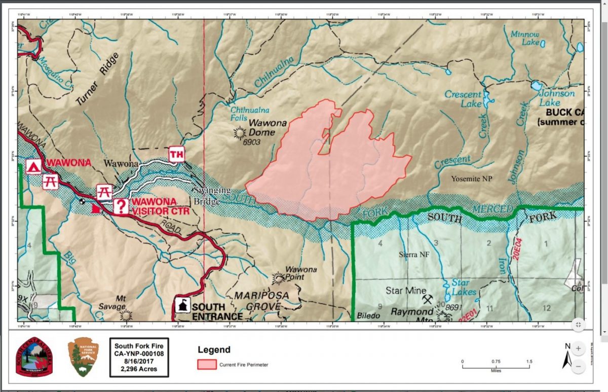
The fire is now estimated at 2,407 acres with 7 percent containment.
Incident Commander Deron Mills of the South Central Sierra Interagency Incident Management Team is also the Deputy Fire Chief in Yosemite, so is on his home turf for this fire.
Mills said the objective is to keep the fire in check on the west and south, protect the community of Wawona and the significant resource that is the Mariposa Grove of Big Trees, and keep it from crossing the South Fork of the Merced River onto the Sierra National Forest.
To the north and east are a lot of rock barriers, said Mills who described those areas as “moonscapes,” and they are working to steer the fire into those natural barriers and get the fire to “confine itself.”
Fireline has been cut in on the west flank for protection of Wawona, and yesterday two Hot Shot crews and two Wildland Fire Modules were airlifted to the top of Wawona Dome where they set up a spike camp.
Those 60 firefighters will cut line to the north along the ridge above Chilnualna Creek and tie in to the trail to Buck Camp. As weather conditions allow, they will conduct burn-outs inside that line to remove fuel as the fire approaches from the east, and hold that western flank.
The fire is not being actively suppressed on the north and east, but is headed farther up into the wilderness area where it will do what fires naturally do, and remove decades of duff and dead vegetation, reducing fuel and renewing the forest.
There are currently 449 personnel assigned to the incident, and Mills believes those resources are sufficient to handle the fire.
The main Incident Command Post has been established at the Yosemite Ski & Snowboard Area (Badger Pass) where the management team is operating and firefighters are being fed.
An inconvenient twist to the communications infrastructure is that the phone pedestal at Badger Pass was hit by lightning two weeks ago, so repairs had to be made to get things up and running.
Bridalveil and Wawona Campgrounds have been closed to the public in order to accommodate firefighters’ sleeping arrangements.
With the dangers posed to firefighters by very steep terrain and heavy tree mortality, there will be no night shift working this fire.
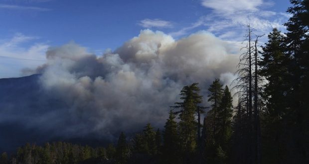
Heavy smoke held down by the inversion in the morning hours — and often well into the afternoon — has limited the number of hours aircraft can work this fire. The crews sent to Wawona Dome were not able to be airlifted until about 3 p.m. yesterday.
While the inversion limits attack from the air, it also dampens the fire behavior, says Mills, as was evidenced by the slower rate of spread yesterday.
Crews are also being assisted by higher humidity over the past two days. There was actually a bit of rain over the fire area yesterday.
On the weather front, a disturbance over the region is forcasted to produce locally breezy conditions over the next couple of days. Humidity trended higher for all locations along with cooler temperatures yesterday. A warming trend will begin on Thursday and continue into the weekend. Increased instability over the Sierra Nevada will bring slight chances of afternoon and early evening showers and thunderstorms through Friday. Winds will be gusty and erratic. Otherwise, mostly clear skies will prevail over Central California.
NPS Law Enforcement Officer Chad Andrews talked last night about evacuation plans, should that become necessary, and urged residents to have their important items ready.
“Get yourselves prepared,” he said. “Have your medications and important documents by the door and ready to go.”
Andrews was clear that there is no imminent threat at this time, but that people should not create additional stress by waiting until the last minute.
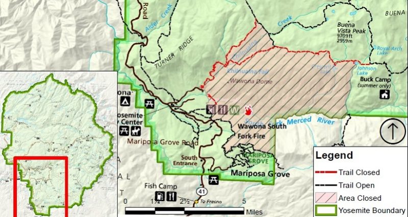
In order to maintain the safety of park visitors and allow fire management operations to continue unimpeded, the Superintendent of Yosemite National Park is designating the following area as closed until further notice is given:
- The Swinging Bridge Trail on both the north and south sides of the South Fork of the Merced River.
- The Chilnualna Falls Trail from Wawona Trailhead to the top of Chilnualna Falls.
- The two mile connecting trail heading north from the top of Chilnualna Falls to the intersection of the Buena Vista Trail.
- The Chilnualna Creek Trail from the top of Chilnualna Falls east to the intersection of the Buena Vista and Buck Camp trails (Just east of Johnson Lake).
- Off-trail areas in the vicinity are closed (i.e. all areas within the shaded circle on the map below).
- All climbing routes on and around Wawona Dome are closed.
“Notice of closure will be posted and area will be monitored to ensure compliance,” say Park officials. “Your cooperation in complying with this temporary restriction is greatly appreciated. The designation will remain in place until rescinded.”
Yesterday morning, the Office of the Superintendent in Yosemite announced these operational changes:
- Wawona Campground is closed.
- Bridalveil Creek Campground closed on Wednesday morning.
- Wawona trail (mule) rides are not operating.
- Big Trees Golf Course is closed.
- The Badger Pass-Glacier Point shuttle will not operate until further notice as the incident command post is occupying the Yosemite Ski and Snowboard Area facility and parking lot.
- The Glacier Point Road will will remain open to the public however it will close periodically between 10 a.m. and 5 p.m. each day when parking at Glacier Point fills to capacity (and will reopen when sufficient space is available). Traffic delays should be expected.
- A voluntary ban on wood fires is in place in Yosemite Valley to reduce smoke. A mandatory ban may be instituted in the days to come.
The South Fork Fire was reported just after 2 p.m. on Sunday, Aug. 13, and is burning on the South Fork of the Merced River drainage, south of Wawona Dome approximately one mile east of the Swinging Bridge.
Heavy smoke continues to impact Wawona and the areas surrounding Yosemite, especially overnight and through the morning hours, adding more smoke to what is being produced by the Empire Fire near Bridalveil Campground, which is now estimated at 1,400 acres.
Air quality in Wawona is expected to be extremely smoky and to reach unhealthy/ hazardous conditions. Smoke is expected to fill the canyons west of Wawona to Mariposa, and affect visibility along Highway 140 from El Portal to Mariposa, Wawona Road south to Fish Camp, and roads along Tioga Pass to the Mono Lake area.
Some of the agencies assisting on the fire, in addition to the National Park Service, include the U.S. Forest Service, BLM, Cal Fire, Mariposa County Fire, Kern County Fire, and a host of county and city fire departments and federal resources.
The cause of the fire is under investigation.
The estimated date of containment is Sunday, Sept. 3.
For additional information:
- Rapid Notify is a community alert system for rapid event notifications. Register by visiting www.alert.rapid notify.com
- Nixle is a public-safety notification system. Sign up for emergency alerts by texting 95389 to 888-777 or visit their website at www.nixle.com
- Fire Information: Yose_Fire_Info@nps.gov
- Yosemite National Park Fire Information website: http://www.nps.gov/yose/blogs/fireinfo.htm
- Facebook, search: Yosemite Fire and Aviation
- Twitter, search @YosemiteFire : http://www.twitter.com/YosemiteFire
Air quality links for Yosemite National Park:
https://app.airsis.com/USFS/UnitMap
https://www.nps.gov/yose/learn/nature/aqmonitoring.htm
Click here for a perimeter map.
Click here for interactive map.
Trail closure map below.