MARIPOSA COUNTY – Firefighters had a productive shift on the Ferguson fire today, and officials expect more sections of the fireline moved into the containment column over the next few days.
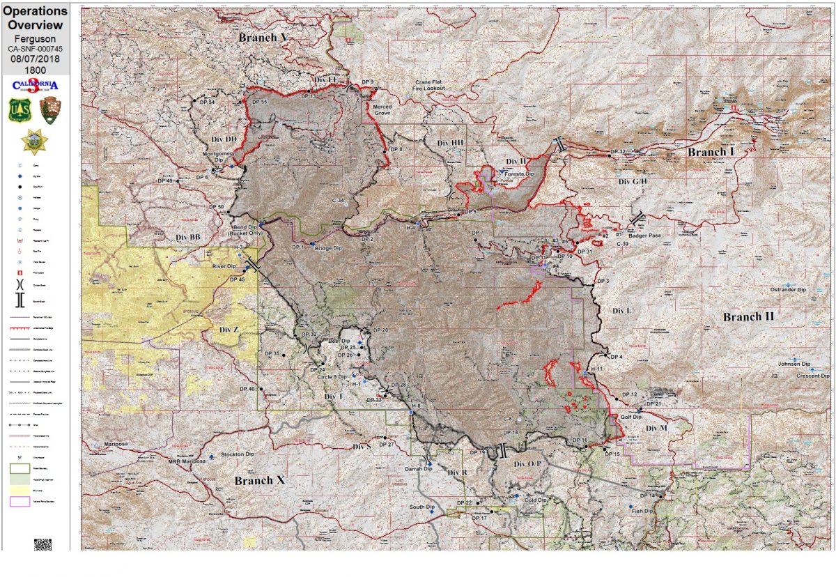
The fire is now estimated at 94,992 acres with 43 percent containment.
Evacuations were lifted for the Highway 140 corridor and Yosemite West, and Highway 120 was reopened. Motorists are cautioned to anticipate delays during their travels around the Ferguson Fire due to road conditions, fire traffic, weather, hazards and smoke conditions.
At a press conference this morning at the Incident Command Post in Ahwahnee, officials talked about the current situation and plans for containing the fire.
Incident Commander Mark von Tillow, Sierra National Forest Supervisor Dean Gould, Yosemite Fire and Aviation Chief Kelly Martin, Mariposa County Sheriff Doug Binnewies, Superintendent of Sequoia and Kings Canyon National Parks Woody Smeck, and Yosemite Public Affairs Officer Scott Gediman focused on the different parts of the fire and the concerns and successes in each.
One point everyone wanted to make very clear is that this is a full-suppression effort, and has been from day one.
“This was not a fire that we wanted, but it’s the fire that we have,” said Chief Martin, a 34-year veteran of fire behavior and operations. “We are really looking at how we can mitigate severe impacts to the land, both in Yosemite National Park and on the Forest.”
Yosemite traditionally manages wildfires for resource objectives in the park. Martin says that is not the case with this fire. They are working to put it out.
She also talked about the unique situation on the north end of the Merced River Canyon and how the park closures are linked to that confluence of roads.
“This main fire spread is actually impacting three main entrances into Yosemite – Highway 41, Highway 140 and Big Oak Flat Road,” she said. “There’s fire on the road; there are firefighters on the road; there are significant issues to firefighter and public safety. These roads need to remain closed until we can mitigate the dangers.”
Martin said firefighters constructed line around the long tunnel on Big Oak Flat Road last night and plan to conduct firing operations there when conditions are favorable, to prevent the fire crossing the road to the north. This is a critical piece to keep in check, she said, and officials are committing a lot of resources to that section of the fire.
“We’re very concerned about the forward spread on both sides of the Merced River Canyon,” said Chief Martin. “If it continues to burn on the north side of the canyon and takes that corner into Yosemite Valley proper, it then engages a lot of the vegetation and dead trees on the north slope. And of course you can’t put firefighters in there; it’s too steep and too dangerous. So there’s the potential for a very long-term impact to Yosemite Valley on the rim, but not the valley itself. That’s one of the things we’re looking at from a fire behavior point of view.”
The other critical section of the fire is the active edge north of Glacier Point Road, east of the Merced River.
“If that continues to burn north, we may not have the choice to close it off until we bring it even with the main fire [near Elephant Rock]. There may be opportunities for some firing, but we don’t know yet. We’re working hard to prevent it turning that corner onto the south rim. Again, that is very difficult terrain, and would be very difficult for suppression efforts. We need to be patient and make sure firefighters have everything they need from us to get their job done successfully.”
Last Friday when the “perfect storm” of low humidity, gusting winds and a lifting of the inversion caused extremely active fire behavior, there was a dramatic run up out of Avalanche Creek toward Badger Pass as the fire jumped Highway 41 north of Yosemite West and blocked off Glacier Point Road. Crews have since been able to use direct attack on several sections of the fireline south of the Glacier Point Road, and were successful in containing a spot fire that could have spread the fire farther south.
Chief Martin noted that the fire has bumped into some old fire scars north of Glacier Point Road – namely the 2011 Avalanche Fire and the 2009 Grouse Fire.
“We’re seeing a significant reduction in the rates of spread as the fire moves into those areas, and a greater ability to get firefighters in there safely,” she said.
When the fire made its run out of Avalanche Creek there was “quite a firefight” around Yosemite West, said Incident Commander Mark von Tillow, but planners had everything in place to defend the community. Cal Fire, Sierra National Forest and the Park Service were ready, as they anticipated the fire’s run based on weather forecasts, fuel conditions and topography. They were successful in defending the community and none of the 207 homes were lost.
Yosemite West does have some continuing infrastructure challenges however, said Mariposa County Sheriff Doug Binnewies.
“The power lines have been damaged, creating issues with water and sewage, but Public Works is working to resolve those problems.”
The mandatory evacuation for Yosemite West was lifted at 7 p.m. this evening. The loss of power has presented an issue with water quality, and residents returning home are being advised to boil their water.
Down near Wawona, officials are very confident about the fireline to the west of the community and anticipate moving that section into the containment column in the next day or so. Crews continue to do mop-up and secure the line.
Across the southern perimeter and up the western flank to the Merced River everything remains in patrol status and suppression repair is underway.
On the northwest corner of the fire burning on the Stanislaus National Forest, favorable conditions have allowed crews to complete the line down from Pilot Peak and tie it in to the containment line on the west flank. Officials expect to move that portion of the line into the contained column by tomorrow.
With the hazard tree mitigation complete on the northeast corner, Highway 120 was reopened north of the Merced Grove of giant sequoias at 1 p.m. today, allowing travel from the west across to Tuolumne Meadows and Tioga Pass. The Big Oak Flat Road into Yosemite Valley remains closed.
Crews did protection work in the Merced Grove over the past week, clearing some fuels and wrapping the historic cabin. The fire has not affected the Grove, say officials.
The fire near the community of Foresta has been a challenge for firefighters and planners over the last few days, but diminishing heat in the Crane Creek drainage has allowed crews to construct direct line up the creek and around the structures. Firefighters have worked diligently in that area since the fire jumped the Merced River on Aug. 3 and ran to the north around both sides of the community. Crews did prep work and point protection, and none of the 50+ structures have been damaged or destroyed.
The Highway 140 corridor was reopened today from Briceburg to the Yosemite National Park entrance gate, and evacuations were lifted for all the communities along the route.
Officials from all agencies are well aware of the adverse impact this fire has had on Yosemite’s gateway communities and on the park itself.
“This is a day-to-day situation, but we want to make it clear that we are endeavoring to get the park open just as soon as it is safe to do so,” said Scott Gediman. “We want everybody to know that we understand that this is impacting businesses in a negative way, and we’re all working together to move forward and balancing that effort with protecting public safety and protecting our firefighters.”
Incident Command Mark von Tillow addressed the issue of tree mortality across the fire’s perimeter.
“There are going to be some good fire effects and some places that are very severe,” he said. “There are places where it’s creeping around on the forest floor and places where it’s more intense. Where the fire came out of Avalanche Creek and crossed Highway 41 – that was probably one of the most intense pieces on this fire.
“As for the dead tree component, when fire gets established in the bug kill fuels, it takes about a quarter of the time to burn down than it would if the trees were healthy. With those fuels dotted all through the fire, we have to be very careful about whether we can attack it there. Is it going to be worth it in that type of fuel bed or better to back off to a different fuel bed? Drought, high temperatures, winds, bug kill – certainly the dead trees are part of the decision making.”
Woody Smeck, Acting Superintendent of Yosemite National Park, was encouraged about some of the beneficial effects for the forest ecology.
“Much of it is smoldering and creeping along the forest floor and doing what fire does in an ecosystem like this that’s adapted to fire,” he said. “The severity is going to be fairly limited in terms of scorching and burned earth, and I think when this is done and we start to implement the burned area recovery work, we’ll see good effects in terms the ecology and the forest health.”
Sierra National Forest Supervisor Dean Gould said he is always looking for opportunity out of adversity.
“There has been some pretty robust discussion among the land managers and the cooperating agencies about how can we best reduce the risk of something of this magnitude happening in the future. We’re looking at cross-boundary treatments and a lot more collaboration in terms of what we’re able to do on the land by pooling our resources together.”
Gould has placed an order for a BAER (Burned Area Emergency Response) Team – a group of technical professionals who assess the entire footprint of the fire for damages and determine what must be done to prevent further damage to life, property or natural resources before winter weather arrives.
Sheriff Doug Binnewies expressed his deep gratitude on behalf of the residents of Mariposa County for the tireless work of all the fire professionals, and says his department will continue to build on lessons learned in the Detwiler Fire and partnerships with residents and agencies.
“We are very grateful to the community for their trust, for the communication, and the responsiveness to the Nixle emergency messaging to get folks out of harm’s way. Things are changing, and we need to look at fire and fire management a lot differently and get out in front of it. We are sad to say that some historic mine buildings have been lost, but we’re very excited that none of the inhabited homes were lost due to the pre-planning, the clearing and the direct firefighting.”
The Ferguson Fire started on Friday, July 13, at 8:30 p.m., near Savage Trading Post on the south side of the Merced River canyon along Highway 140. The cause remains under investigation.
The estimated date for full containment is Aug. 15.
There are currently 2,357 personnel assigned to the incident including 202 engines, 39 crews, 18 water tenders, 33 dozers, 5 masticators, 14 helicopters, and fixed-wing tankers as conditions allow.
Officials report 995 structures threatened by the fire. Ten structures have been destroyed. Damage assessment teams have been able to get into some of the burn areas of the fire, and report that most of the 10 structures reported lost were in the Ned Gulch area on the north end of the fire. According to locals, these were historic mining operation structures that were being restored and used weekly for various types of outings and expeditions.
There have been 12 firefighter injuries reported, and numerous instances of heat exhaustion-type symptoms. There have been two fatalities on the fire; HFEO Braden Varney was killed in a dozer rollover accident on July 14, and Brian Hughes, Arrowhead Hotshot Captain, lost his life on July 29 when he was struck by a tree during a firing operation.
Yosemite National Park
Officials have announced that the closure of some portions of Yosemite National Park will be extended indefinitely. When the park does open these areas, limited visitor services will be available inside Yosemite Valley, including campgrounds, lodging, and food service operations.
Yosemite Valley has been closed since July 25 due to smoke impacts and for firefighting operations along El Portal Road and the Wawona Road.
The Mariposa Grove of Giant Sequoias and the Wawona Road (Highway 41) from the south entrance of Yosemite National Park to Tunnel View will remain closed until further notice.
The Big Oak Flat Road (Highway 120 West) to Crane Flat has been reopened. Tioga Road (Highway 120 East) from Crane Flat to Tioga Pass, remains open to all visitors and vehicles. All trails and campgrounds along Tioga Road, including the Tuolumne Meadows Campground remain open. All visitor services along Tioga Road, including the High Sierra Camps and visitor services near Tuolumne Meadows, remain open.
Non-essential personnel in Yosemite Valley were evacuated Friday due to hazardous road conditions, smoke and a loss of power, say park officials. Yosemite Valley has been closed to the public since July 25, however Yosemite National Park remains open on the east side out of Lee Vining, and Tioga Pass Road (Highway 120 East) provides access to the Tuolumne Meadows Visitor Center, the Pacific Crest and John Muir trails.
Yosemite National Park is working closely with the Incident Management Team and continues to assess park conditions daily.
For updated 24-hour road and weather conditions for Yosemite National Park, please call 209-372-0200, press 1 and press 1 again. Updated information is also available on the park’s website at www.nps.gov/yose and on the Yosemite National Park Facebook page.
Air quality issues
For information on air quality specific to Mariposa County visit http://www.mariposacounty.org/index.aspx?NID=1434. For additional information on air quality you can visit the AirNow website or the air fire smoke page.
The San Joaquin Valley Air Pollution Control District has also warned that a health caution is in place and smoke impacts will continue until the fire is extinguished.
Wildfire smoke is a mixture of gases and fine, microscopic particles that can cause health problems including triggering asthma attacks, aggravating chronic heart and lung diseases, and increasing the risk of heart attack and stroke. Where conditions warrant, people with heart or lung disease should follow their doctors’ advice for dealing with episodes of particulate exposure. People with existing respiratory conditions, young children and elderly people are especially susceptible to the health effects from these pollutants. Anyone being exposed to poor air quality or wildfire smoke should move inside to an air-conditioned environment.
Residents can check the San Joaquin Valley Air Pollution Control District’s wildfire page at www.valleyair.org/wildfires for information about any current wildfires and whether they are impacting the Valley. The District’s Real-time Air Advisory Network (RAAN) provides localized air quality data from an extensive air-monitoring network which allows Valley residents to track PM at any Valley address by visiting myraan.com.
If community members see new fire activity, they are asked to call 911, not the fire information line.
As of July 21, there are fire restrictions in place on the Sierra National Forest. Please read and be informed before you use any type of fire in the forest.
The Incident Command Post for the Ferguson Fire is located at the Ahwahnee Hills Regional Park. Please be aware of heavy fire equipment moving through the area. There is also a base camp set up on the Stanislaus National Forest. Personnel at the fire camp at Badger Pass have been relocated to the ICP in Ahwahnee due to active fire in the area.
Cal Fire exited Unified Command as of 6 a.m., Thursday, July 26, because of reduced threats to state and private lands. Cal Fire remains committed to the Ferguson Incident as an assisting agency. California Interagency Incident Management Team 3, led by Incident Commander Mark von Tillow, has assumed management of the Ferguson Fire as of 6 a.m. on Friday, Aug. 3, transitioning in for California Team 4, which had be managing the fire since July 19.
For information about the fire please call 530-377-6221.
Stanislaus National Forest Supervisor Jason Kuiken has signed a forest order closing several Groveland Ranger District roads and trails impacted by the Ferguson Fire. This closure is based on the current and expected fire behavior and will be in effect until Sept. 30, or until replaced or rescinded. Click here for details and a map of the closure.
Be sure you are signed up to receive alerts when wildfire or other emergencies threaten.
- To sign up for the Mariposa Sheriff’s Office Emergency Alert System visit https://local.nixle.com/register.
- To register for the Madera County Sheriff’s Office Emergency Alert System visit mcalert.org.
Evacuations
New today: Highway 120 reopened at 1 p.m. The Big Oak Flat Road remains closed.
Evacuation orders were lifted for Anderson Valley, Hall Gulch and Old Yosemite in the Greeley Hill Area.
Highway 140 is now open from Briceburg to the Yosemite National Park entrance gate. Yosemite Valley remains closed.
Evacuation orders were lifted at 7 p.m. for Yosemite West. Residents must enter through the south gate on Highway 41.Due to the power outage and stoppage of water service a boil order has been issued. Residents are advised not to drink or cook with tap water until further notice. For further information on the boil order please contact Mariposa County Public Works Department at 209-966-5356.
Mandatory evacuations remain in place for:
- Foresta
- Yosemite Valley
A Red Cross Evacuation Center has been established at New Life Christian Fellowship, 5089 Cole Road in Bootjack.
If you have been evacuated due to the Ferguson Fire, the Sheriff’s Office asks that you please check in with the Red Cross Shelter even if you do not plan to stay there.
If you are in a Mandatory Evacuation or Advisory Area and may require assistance with evacuation transportation due to special needs or medical issues, please contact Human Services toll free at 1-833-423-0816 as soon as possible.
Planning ahead will help with a safe and timely evacuation.
Animal Evacuation Centers
The Central California Animal Disaster Team (CCADT) has closed their emergency animal shelter at the Mariposa Elementary School, as all the pets have gone home. If you have small animals and have been evacuated, please call CCADT at 888-402-2238 ext. 0. If no one answers, leave a message. Someone will return your call as soon as possible.
Large Animal Shelter is at the Mariposa County Fairgrounds, 5007 Fairgrounds Road in Mariposa.
Road Closures
- Foresta Road
- Summit Road
- Highway 41 from the south gate of Yosemite to Yosemite Valley (Bridalveil Fall)
General information on returning to previously evacuated areas:
Mariposa County Sheriff’s Office will have a heavy presence in the area to ensure the security and safety of residents and businesses.
There will still be smoke in the respective areas as firefighters continue firefighting operations. If at any time you feel unsafe, please call 911.
For questions or concerns regarding power, please contact PG&E at 800-743-5000 or visit their website at www.pge.com.
The Mariposa County Health Department has health and safety information for residents returning to their homes on their website at http://www.mariposacounty.org/health or call 209-966-3689.
Mariposa County Health and Human Services will be available to assist residents with gaining additional services. Additional information regarding these and other services is available at www.mariposacountyrecovers.org.
SAFETY MESSAGE – The public is reminded to stay vigilant on current fire conditions. Please continue to adhere to road closures and any evacuation warnings. If you see electrical wires on the ground, stay clear and contact PG&E immediately. Trees and poles with deep charring, particularly if still smoking, should be considered hazardous. Please drive slowly and yield to emergency personnel in the area. As you re-enter your property and evaluate damage, be aware that hazardous conditions may exist, particularly if a residence or out-building has burned. Hazards may include asbestos, heavy metals, by-products of plastic combustion and various other chemicals. We encourage the public to remain prepared year-round for wildfires by visiting the www.readyforwildfire.org website. The best show of support is having your home and property “fire-ready.”
Cooperating Agencies on the Ferguson Fire include:
- Bureau of Land Management
- California Conservation Corps
- California Department of Corrections
- California Highway Patrol
- California Office of Emergency Services
- Cal Fire
- Caltrans
- Central Califonia Animal Disaster Team
- Hetch Hetchy Water & Power
- Madera County Sheriff
- Mariposa County Public Works
- Mariposa Public Works
- North Fork Rancheria of Mono Indian of California
- Pacific Gas and Electric
- Red Cross
- San Francisco Department of Emergency Management
- Sierra Tel
- Tuolumne County Sheriff
- Yosemite Mountain Ranch
Please note that the Public Information map does not reflect the opening of Highway 120 and 140 this morning.